
16 Bus Route Map
View the 16 route map and see all 16 stops along the route. The map of 16 shows where the bus travels and the location of each stop, making it easy to understand the entire route at a glance.
Explore FARGO routes on the map and see where FARGO bus services operate. Use the 16 map to find bus stops and see how the 16 connects different areas along its trip.
All 16 stops on the map are displayed in route order, helping you follow the 16 bus from the first stop to the last.
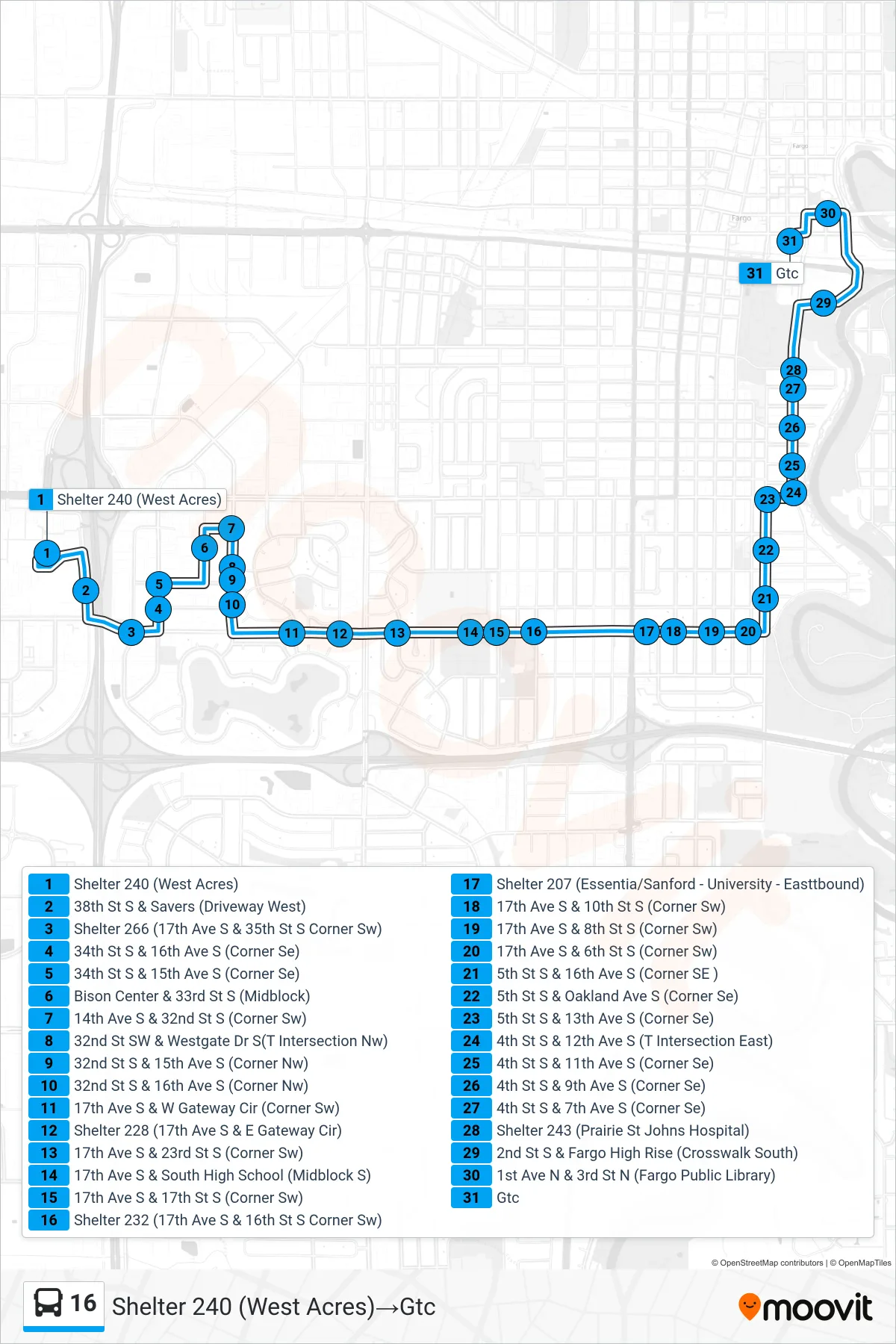
Stops list (16 - Shelter 240 (West Acres)→Gtc)
- Shelter 240 (West Acres)
- 38th St S & Savers (Driveway West)
- Shelter 266 (17th Ave S & 35th St S Corner Sw)
- 34th St S & 16th Ave S (Corner Se)
- 34th St S & 15th Ave S (Corner Se)
- Bison Center & 33rd St S (Midblock)
- 14th Ave S & 32nd St S (Corner Sw)
- 32nd St SW & Westgate Dr S(T Intersection Nw)
- 32nd St S & 15th Ave S (Corner Nw)
- 32nd St S & 16th Ave S (Corner Nw)
- 17th Ave S & W Gateway Cir (Corner Sw)
- Shelter 228 (17th Ave S & E Gateway Cir)
- 17th Ave S & 23rd St S (Corner Sw)
- 17th Ave S & South High School (Midblock S)
- 17th Ave S & 17th St S (Corner Sw)
- Shelter 232 (17th Ave S & 16th St S Corner Sw)
- Shelter 207 (Essentia/Sanford - University - Easttbound)
- 17th Ave S & 10th St S (Corner Sw)
- 17th Ave S & 8th St S (Corner Sw)
- 17th Ave S & 6th St S (Corner Sw)
- 5th St S & 16th Ave S (Corner SE )
- 5th St S & Oakland Ave S (Corner Se)
- 5th St S & 13th Ave S (Corner Se)
- 4th St S & 12th Ave S (T Intersection East)
- 4th St S & 11th Ave S (Corner Se)
- 4th St S & 9th Ave S (Corner Se)
- 4th St S & 7th Ave S (Corner Se)
- Shelter 243 (Prairie St Johns Hospital)
- 2nd St S & Fargo High Rise (Crosswalk South)
- 1st Ave N & 3rd St N (Fargo Public Library)
- Gtc