
16 Bus Route Map
View the 16 route map and see all 16 stops along the route. The map of 16 shows where the bus travels and the location of each stop, making it easy to understand the entire route at a glance.
Explore Dan routes on the map and see where Dan bus services operate. Use the 16 map to find bus stops and see how the 16 connects different areas along its trip.
All 16 stops on the map are displayed in route order, helping you follow the 16 bus from the first stop to the last.
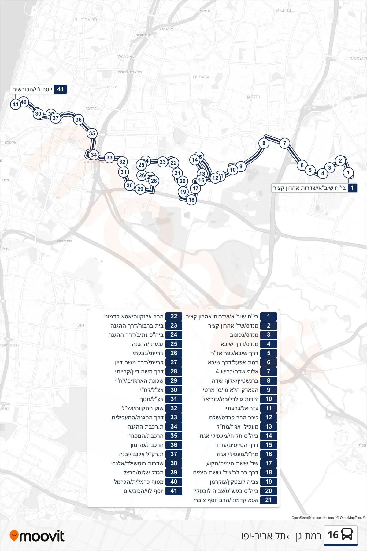
Stops list (16 - Ramat Gan→Tel Aviv-Yafo)
- Sheba Hospital/Aharon Katzir Boulevard
- Mendes/Aharon Katzir Blvd
- Mendes/Gafunov
- Mendes/Sheba Road
- Sheba Road/Kfar Azar
- Ramat Efal/Sheba Road
- Aluf Sadeh/Road 4
- Bernstein/Aluf Sadeh
- National Park/San Martin
- Yahadut Philadelphia/Azriel
- Azriel/Givati
- Rabbi Pardes Square/Shalem
- Maapilei Egoz/Machal
- Tel Hai School/Ma'apilei Egoz
- Pilots Road/Oded
- Machal/Ma'apilei Egoz
- Six Day War Blvd/Tekoa
- Bar Lev Road/Six Day War Blvd
- Tzevia Lubetkin/Zukerman
- Besht School/Tzviya Lubetkin
- Asa Kadmoni/Rabbi Yosef Tzuveri
- Rav Elnekave/Asa Kadmoni
- Beit Barbur/HaHagana Road
- Nativ School/HaHagana Road
- Givati/HaHagana
- Kiryati/Givati
- Kiryati/Moshe Dayan Road
- Moshe Dayan Road/Kiryati
- Argazim Neighborhood/Lehi
- Etzel/Lehi
- Etzel/Hanoch
- Hatikva Market/Etzel
- HaHagana Road/HaMa'apilim
- HaHagana Railway Station
- HaRakevet/HaMasger
- HaRakevet/Solomon
- Allenby Light Rail Station/Yavne
- Rothschild Boulevard/Allenby
- Shalom Tower/Herzl
- Carmelit Terminal/HaCarmel
- Yosef Levi/HaKovshim