
16A Bus Route Map
View the 16A route map and see all 16A stops along the route. The map of 16A shows where the bus travels and the location of each stop, making it easy to understand the entire route at a glance.
Explore Nateev Express routes on the map and see where Nateev Express bus services operate. Use the 16A map to find bus stops and see how the 16A connects different areas along its trip.
All 16A stops on the map are displayed in route order, helping you follow the 16A bus from the first stop to the last.
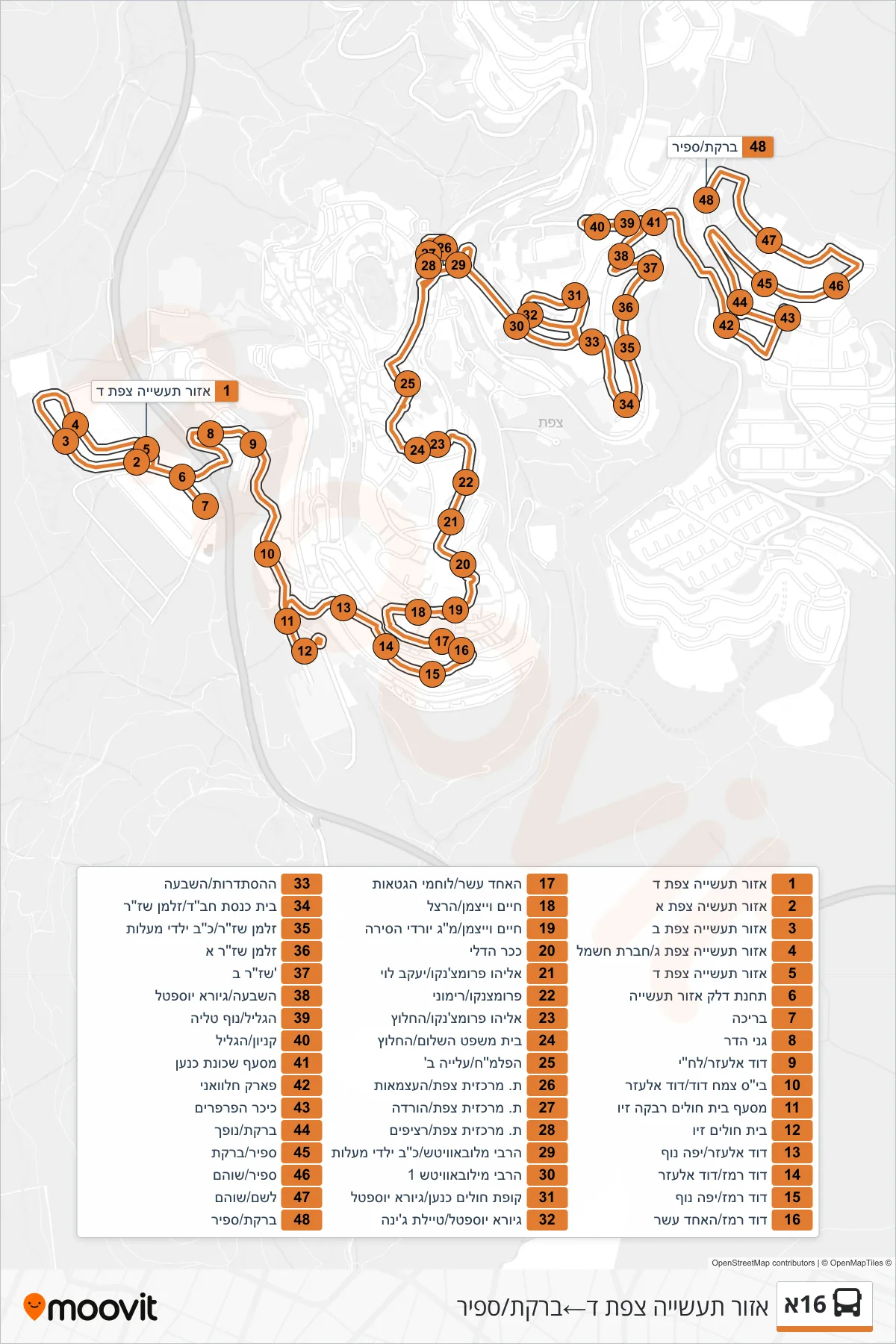
Stops list (16A - Tzfat Industrial Zone D→Bareket/Sapir)
- Tzfat Industrial Zone D
- Safed Industrial Zone A
- Tzfat Industrial Zone B
- Safed Industrial Zone C/Electric Company
- Tzfat Industrial Zone D
- Fuel Station Industrial Zone
- Pool
- Ganei Hadar
- David Elazar/Lehi
- Tzemah David School/David Elazar
- Rivka Ziv Hospital Junction
- Ziv Hospital
- David Elazar/Yefe Nof
- David Remez/David Elazar
- David Remez/Yafe Nof
- David Remez/Ha'Achad Asar
- The Eleventh/Ghetto Fighters
- Chaim Weizmann/Herzl
- Chaim Weizmann/M.G. Yordei HaSira
- Deli Square
- Eliyahu Promchenko/Yaakov Levi
- Promtzenko/Rimoni
- Eliyahu Promchenko/HaHalutz
- Magistrate Court/HeChalutz
- Palmach/Aliyah B
- Tzfat Central Station/HaAtzmaut
- Safed Central Station/Drop Off
- Safed Central Station/Platforms
- Lubavitcher Rebbe/22 Maalot Children
- 1 Lubavitcher Rebbe
- Kupat Holim Canaan/Giora Yoseftal
- Giora Yoseftal/Gina Promenade
- HaHistadrut/HaShiva
- Chabad Synagogue/Zalman Shazar
- Zalman Shazar/22 Ma'alot Children
- Zalman Shazar A
- Shazar B
- HaShiva/Giora Yoseftal
- HaGalil/Nof Talia
- Mall/HaGalil
- Canaan Neighborhood Junction
- Halawani Park
- Butterfly Square
- Bareket/Nofech
- Sapir/Bareket
- Sapir/Shoham
- Leshem/Shoham
- Bareket/Sapir