
18A Bus Route Map
View the 18A route map and see all 18A stops along the route. The map of 18A shows where the bus travels and the location of each stop, making it easy to understand the entire route at a glance.
Explore Egged routes on the map and see where Egged bus services operate. Use the 18A map to find bus stops and see how the 18A connects different areas along its trip.
All 18A stops on the map are displayed in route order, helping you follow the 18A bus from the first stop to the last.
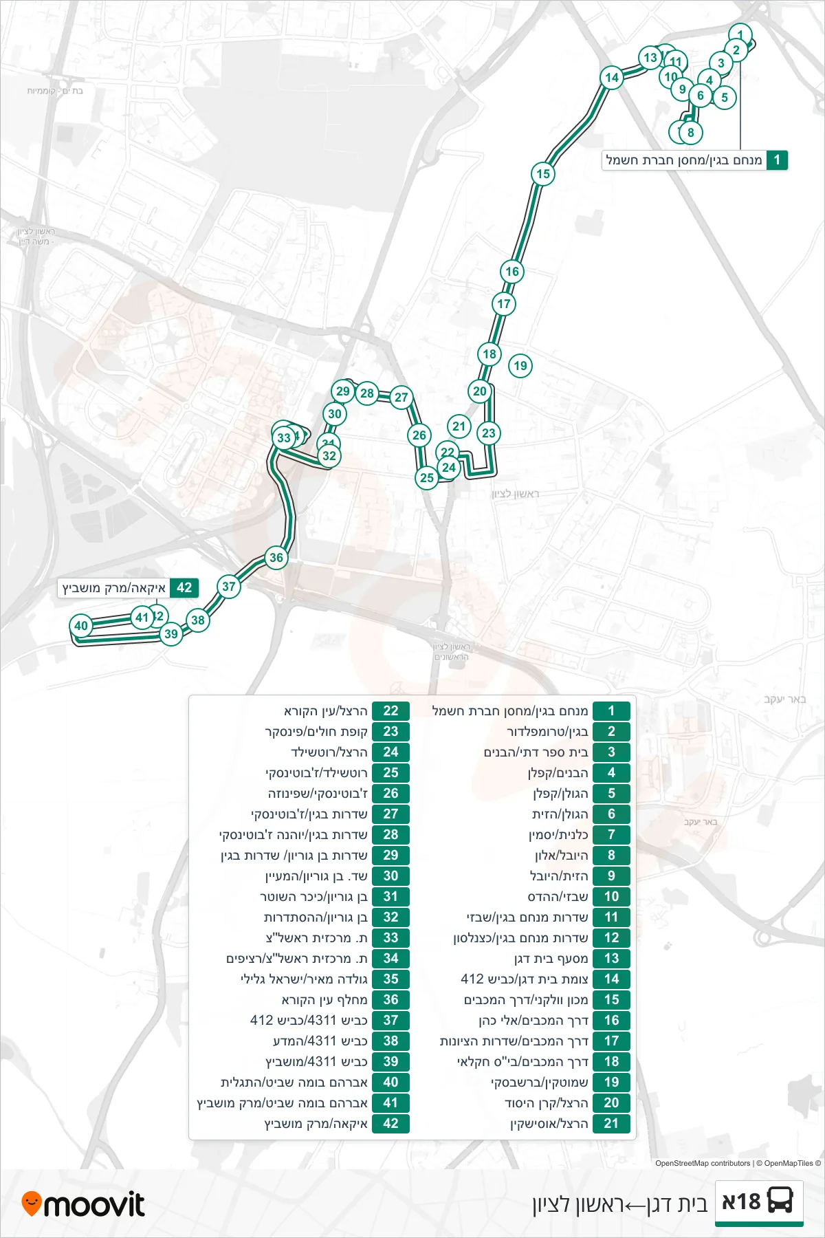

Stops list (18A - Beit Dagan→Rishon LeZion)
- Menachem Begin/Electric Company Storage
- Begin/Trumpeldor
- Religious School/HaBanim
- HaBanim/Kaplan
- HaGolan/Kaplan
- HaGolan/HaZayit
- Kalanit/Yasmin
- HaYovel/Alon
- HaZayit/HaYovel
- Shabazi/HaHadas
- Menachem Begin Boulevard/Shabazi
- Menachem Begin Blvd/Katznelson
- Beit Dagan Junction
- Beit Dagan Junction/Road 412
- Volcani Institute/Maccabim Road
- Derech HaMaccabim/Eli Cohen
- HaMaccabim Road/HaTzionut Boulevard
- HaMaccabim Road/Agricultural School
- Herzl/Keren HaYesod
- Herzl/Ussishkin
- Herzl/Ein HaKore
- Health Center/Pinsker
- Herzl/Rothschild
- Jabotinsky/Azar
- Jabotinsky/Spinoza
- Begin Boulevard/Jabotinsky
- Begin Boulevard/Johanna Jabotinsky
- Ben Gurion Boulevard/Begin Boulevard
- Ben Gurion Blvd/HaMaayan
- Ben Gurion/Police Square
- Ben Gurion/HaHistadrut
- Rishon LeZion Central Station
- Rishon LeZion Central Station/Platforms
- Golda Meir/Israel Galili
- Ein HaKore Interchange
- Road 4311/Road 412
- Road 4311/HaMada
- Road 4311/Moshevitz
- Avraham Buma Shavit/HaTaglit
- Avraham Buma Shavit/Mark Moshevitz
- IKEA/Mark Moshevitz