
18 Light Rail Route Map
View the 18 route map and see all 18 stops along the route. The map of 18 shows where the light rail travels and the location of each stop, making it easy to understand the entire route at a glance.
Explore KVB Kölner Verkehrs-Betriebe AG routes on the map and see where KVB Kölner Verkehrs-Betriebe AG light rail services operate. Use the 18 map to find light rail stations and see how the 18 connects different areas along its trip.
All 18 stops on the map are displayed in route order, helping you follow the 18 light rail from the first station to the last.
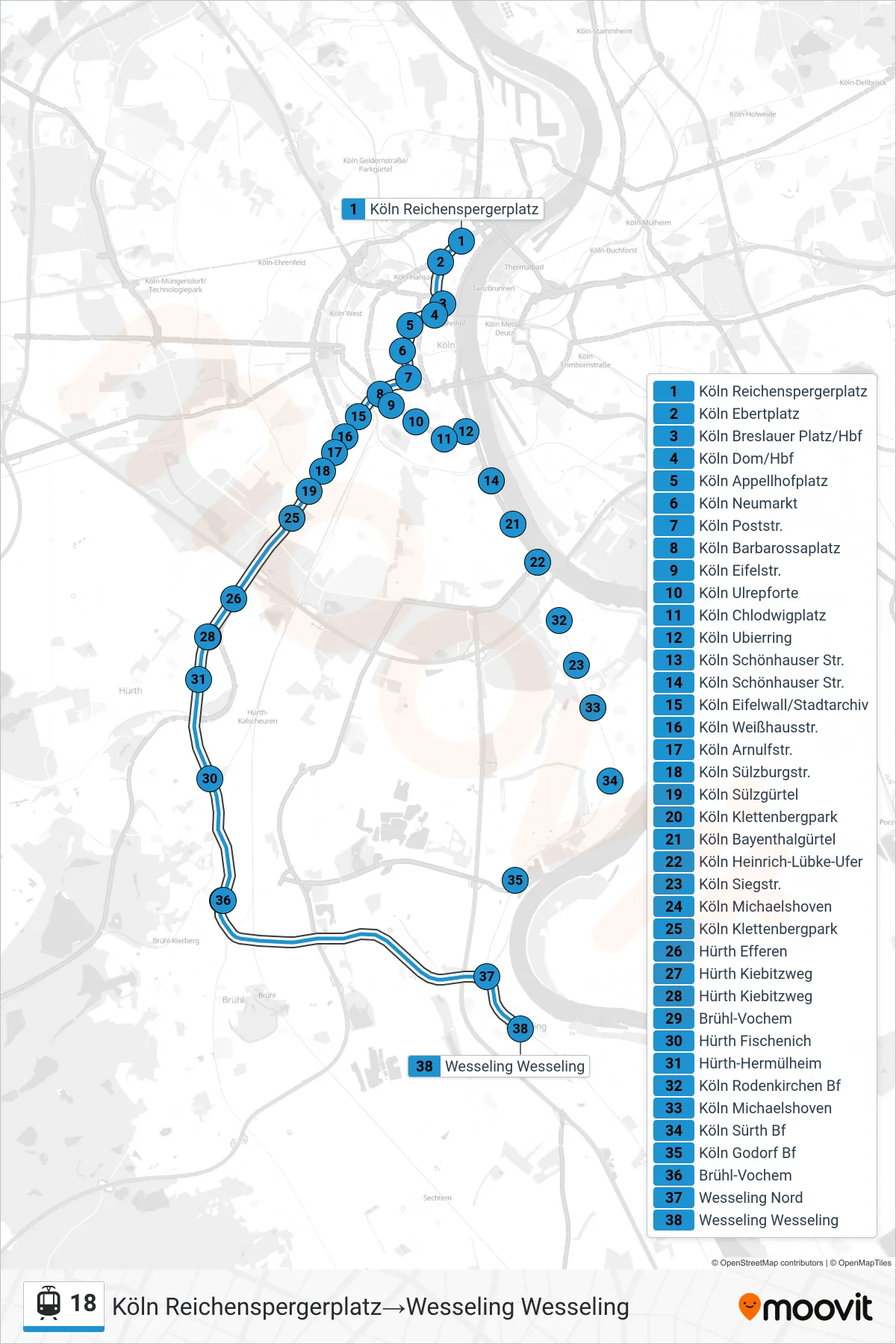

Stops list (18 - Köln Reichenspergerplatz→Wesseling Wesseling)
- Köln Reichenspergerplatz
- Köln Ebertplatz
- Köln Breslauer Platz/Hbf
- Köln Dom/Hbf
- Köln Appellhofplatz
- Köln Neumarkt
- Köln Poststr.
- Köln Barbarossaplatz
- Köln Eifelstr.
- Köln Eifelwall/Stadtarchiv
- Köln Ulrepforte
- Köln Weißhausstr.
- Köln Arnulfstr.
- Köln Chlodwigplatz
- Köln Ubierring
- Köln Sülzburgstr.
- Köln Sülzgürtel
- Köln Schönhauser Str.
- Köln Bayenthalgürtel
- Köln Heinrich-Lübke-Ufer
- Köln Klettenbergpark
- Hürth Efferen
- Hürth Kiebitzweg
- Hürth Fischenich
- Köln Siegstr.
- Köln Michaelshoven
- Köln Sürth Bf
- Köln Godorf Bf
- Hürth-Hermülheim
- Köln Rodenkirchen Bf
- Brühl-Vochem
- Wesseling Nord
- Wesseling Wesseling
Change direction
- Route Map - 18 - Brühl Mitte→Bonn Dransdorf
- Route Map - 18 - Wesseling Wesseling→Bonn Dransdorf
- Route Map - 18 - Köln Buchheim Herler Str.→Köln Reichenspergerplatz
- Route Map - 18 - Wesseling Wesseling→Brühl Mitte
- Route Map - 18 - Köln Buchheim Herler Str.→Bonn Hbf
- Route Map - 18 - Köln Buchheim Herler Str.→Brühl Schwadorf
- Route Map - 18 - Köln Barbarossaplatz→Köln Buchheim Herler Str.
- Route Map - 18 - Köln Reichenspergerplatz→Köln Klettenbergpark
- Route Map - 18 - Brühl Schwadorf→Köln Melatengürtel
- Route Map - 18 - Brühl Schwadorf→Bonn Dransdorf
- Route Map - 18 - Brühl Mitte→Wesseling Wesseling
- Route Map - 18 - Brühl Mitte→Bonn Hbf
- Route Map - 18 - Bonn Dransdorf→Wesseling Wesseling
- Route Map - 18 - Köln Klettenbergpark→Köln Buchheim Herler Str.
- Route Map - 18 - Köln Klettenbergpark→Brühl Schwadorf
- Route Map - 18 - Köln Buchheim Herler Str.→Wesseling Wesseling
- Route Map - 18 - Bonn Dransdorf→Köln Buchheim Herler Str.
- Route Map - 18 - Hürth-Hermülheim→Köln Buchheim Herler Str.
- Route Map - 18 - Hürth-Hermülheim→Köln Klettenbergpark
- Route Map - 18 - Köln Klettenbergpark→Wesseling Wesseling
- Route Map - 18 - Bonn Dransdorf→Brühl Mitte
- Route Map - 18 - Köln Klettenbergpark→Köln Reichenspergerplatz
- Route Map - 18 - Köln Buchheim Herler Str.→Köln Klettenbergpark
- Route Map - 18 - Wesseling Wesseling→Köln Reichenspergerplatz
- Route Map - 18 - Köln Buchheim Herler Str.→Bonn Dransdorf
- Route Map - 18 - Brühl Schwadorf→Köln Klettenbergpark
- Route Map - 18 - Wesseling Wesseling→Köln Klettenbergpark
- Route Map - 18 - Bonn Hbf→Wesseling Wesseling
- Route Map - 18 - Bonn Hbf→Köln Buchheim Herler Str.
- Route Map - 18 - Brühl Schwadorf→Köln Buchheim Herler Str.
- Route Map - 18 - Wesseling Wesseling→Köln Buchheim Herler Str.
- Route Map - 18 - Bonn Hbf→Brühl Mitte
- Route Map - 18 - Brühl Schwadorf→Bonn Hbf
- Route Map - 18 - Wesseling Wesseling→Brühl Schwadorf
- Route Map - 18 - Köln Reichenspergerplatz→Hürth-Hermülheim
- Route Map - 18 - Brühl Schwadorf→Wesseling Wesseling
- Route Map - 18 - Köln Buchheim Herler Str.→Hürth-Hermülheim
- Route Map - 18 - Wesseling Wesseling→Bonn Hbf