
184 Bus Route Map
View the 184 route map and see all 184 stops along the route. The map of 184 shows where the bus travels and the location of each stop, making it easy to understand the entire route at a glance.
Explore BVG routes on the map and see where BVG bus services operate. Use the 184 map to find bus stops and see how the 184 connects different areas along its trip.
All 184 stops on the map are displayed in route order, helping you follow the 184 bus from the first stop to the last.
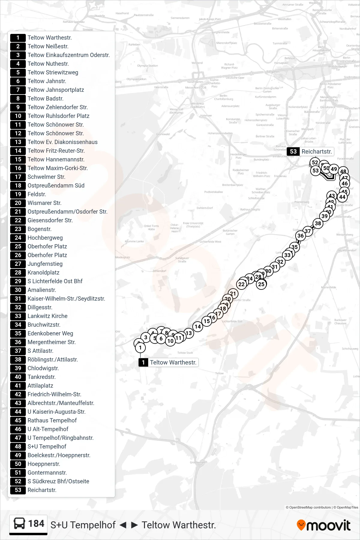
Stops list (184 - Reichartstr.)
- Teltow Warthestr.
- Teltow Neißestr.
- Teltow Einkaufszentrum Oderstr.
- Teltow Nuthestr.
- Teltow Striewitzweg
- Teltow Jahnstr.
- Teltow Jahnsportplatz
- Teltow Badstr.
- Teltow Zehlendorfer Str.
- Teltow Ruhlsdorfer Platz
- Teltow Schönower Str.
- Teltow Schönower Str.
- Teltow Ev. Diakonissenhaus
- Teltow Fritz-Reuter-Str.
- Teltow Hannemannstr.
- Teltow Maxim-Gorki-Str.
- Schwelmer Str.
- Ostpreußendamm Süd
- Feldstr.
- Wismarer Str.
- Ostpreußendamm/Osdorfer Str.
- Giesensdorfer Str.
- Bogenstr.
- Hochbergweg
- Oberhofer Platz
- Oberhofer Platz
- Jungfernstieg
- Kranoldplatz
- S Lichterfelde Ost Bhf
- Amalienstr.
- Kaiser-Wilhelm-Str./Seydlitzstr.
- Dillgesstr.
- Lankwitz Kirche
- Bruchwitzstr.
- Edenkobener Weg
- Mergentheimer Str.
- S Attilastr.
- Röblingstr./Attilastr.
- Chlodwigstr.
- Tankredstr.
- Attilaplatz
- Friedrich-Wilhelm-Str.
- Albrechtstr./Manteuffelstr.
- U Kaiserin-Augusta-Str.
- Rathaus Tempelhof
- U Alt-Tempelhof
- U Tempelhof/Ringbahnstr.
- S+U Tempelhof
- Boelckestr./Hoeppnerstr.
- Hoeppnerstr.
- Gontermannstr.
- S Südkreuz Bhf/Ostseite
- Reichartstr.