
2 Bus Route Map
View the 2 route map and see all 2 stops along the route. The map of 2 shows where the bus travels and the location of each stop, making it easy to understand the entire route at a glance.
Explore Manchester Transit Authority routes on the map and see where Manchester Transit Authority bus services operate. Use the 2 map to find bus stops and see how the 2 connects different areas along its trip.
All 2 stops on the map are displayed in route order, helping you follow the 2 bus from the first stop to the last.
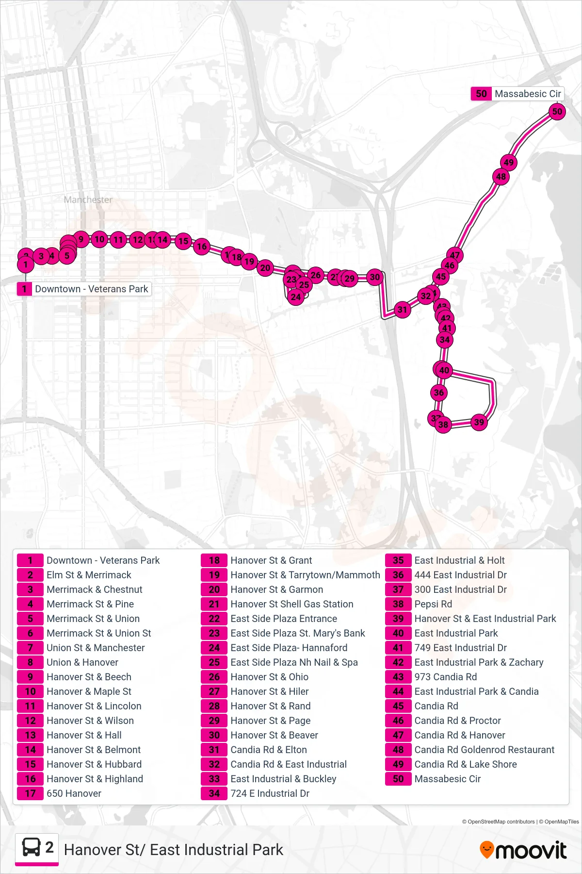
Stops list (2 - E. Industrial Park Via Hanover)
- Downtown - Veterans Park
- Elm St & Merrimack
- Merrimack & Chestnut
- Merrimack St & Pine
- Merrimack St & Union
- Merrimack St & Union St
- Union St & Manchester
- Union & Hanover
- Hanover St & Beech
- Hanover & Maple St
- Hanover St & Lincolon
- Hanover St & Wilson
- Hanover St & Hall
- Hanover St & Belmont
- Hanover St & Hubbard
- Hanover St & Highland
- 650 Hanover
- Hanover St & Grant
- Hanover St & Tarrytown/Mammoth
- Hanover St & Garmon
- Hanover St Shell Gas Station
- East Side Plaza Entrance
- East Side Plaza St. Mary's Bank
- East Side Plaza- Hannaford
- East Side Plaza Nh Nail & Spa
- Hanover St & Ohio
- Hanover St & Hiler
- Hanover St & Rand
- Hanover St & Page
- Hanover St & Beaver
- Candia Rd & Elton
- Candia Rd & East Industrial
- East Industrial & Buckley
- 724 E Industrial Dr
- East Industrial & Holt
- 444 East Industrial Dr
- 300 East Industrial Dr
- Pepsi Rd
- Hanover St & East Industrial Park
- East Industrial Park
- 749 East Industrial Dr
- East Industrial Park & Zachary
- 973 Candia Rd
- East Industrial Park & Candia
- Candia Rd
- Candia Rd & Proctor
- Candia Rd & Hanover
- Candia Rd Goldenrod Restaurant
- Candia Rd & Lake Shore
- Massabesic Cir