
2 Bus Route Map
View the 2 route map and see all 2 stops along the route. The map of 2 shows where the bus travels and the location of each stop, making it easy to understand the entire route at a glance.
Explore RTC RIDE routes on the map and see where RTC RIDE bus services operate. Use the 2 map to find bus stops and see how the 2 connects different areas along its trip.
All 2 stops on the map are displayed in route order, helping you follow the 2 bus from the first stop to the last.
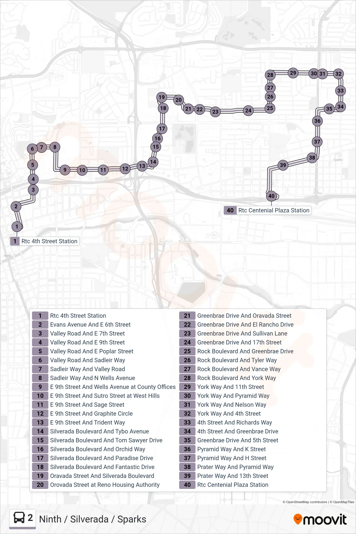
Stops list (2 - Rtc Centennial Plaza Station)
- Rtc 4th Street Station
- Evans Avenue And E 6th Street
- Valley Road And E 7th Street
- Valley Road And E 9th Street
- Valley Road And E Poplar Street
- Valley Road And Sadleir Way
- Sadleir Way And Valley Road
- Sadleir Way And N Wells Avenue
- E 9th Street And Wells Avenue at County Offices
- E 9th Street And Sutro Street at West Hills
- E 9th Street And Sage Street
- E 9th Street And Graphite Circle
- E 9th Street And Trident Way
- Silverada Boulevard And Tybo Avenue
- Silverada Boulevard And Tom Sawyer Drive
- Silverada Boulevard And Orchid Way
- Silverada Boulevard And Paradise Drive
- Silverada Boulevard And Fantastic Drive
- Oravada Street And Silverada Boulevard
- Orovada Street at Reno Housing Authority
- Greenbrae Drive And Oravada Street
- Greenbrae Drive And El Rancho Drive
- Greenbrae Drive And Sullivan Lane
- Greenbrae Drive And 17th Street
- Rock Boulevard And Greenbrae Drive
- Rock Boulevard And Tyler Way
- Rock Boulevard And Vance Way
- Rock Boulevard And York Way
- York Way And 11th Street
- York Way And Pyramid Way
- York Way And Nelson Way
- York Way And 4th Street
- 4th Street And Richards Way
- 4th Street And Greenbrae Drive
- Greenbrae Drive And 5th Street
- Pyramid Way And K Street
- Pyramid Way And H Street
- Prater Way And Pyramid Way
- Prater Way And 13th Street
- Rtc Centenial Plaza Station