
200 Bus Route Map
View the 200 route map and see all 200 stops along the route. The map of 200 shows where the bus travels and the location of each stop, making it easy to understand the entire route at a glance.
Explore Kavim routes on the map and see where Kavim bus services operate. Use the 200 map to find bus stops and see how the 200 connects different areas along its trip.
All 200 stops on the map are displayed in route order, helping you follow the 200 bus from the first stop to the last.
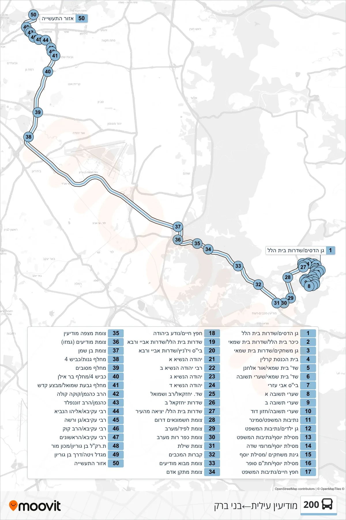
Stops list (200 - Modi'in Illit→Bnei Brak)
- Gan Hadasim/Sderot Beit Hillel
- Beit Hillel Square/Beit Shamai Boulevard
- Playground/Beit Shammai Boulevard
- Karlin Synagogue
- Beit Shamai Boulevard/Or Elhanan
- Beit Shammai Blvd/Shaarei Teshuva
- Avi Ezri School
- Shaarei Teshuva A
- Shaarei Teshuva B
- Shaarei Teshuva/Hazon David
- Netivot HaMishpat/Seminary
- Kindergarten/Netivot HaMishpat
- Mesilat Yosef/Netivot HaMishpat
- Mesilat Yosef/Meromei Sadeh
- Playground/Mesilat Yosef
- Mesilat Yosef/Chatam Sofer
- Chafetz Chaim/Netivot HaMishpat
- Hafetz Haim/Noda BiYehuda
- Beit Hillel Boulevard/Abaye VeRava Boulevard
- Vizhnitz School/Abaye VeRava Boulevard
- Yehuda HaNasi A
- Rabbi Yehuda HaNasi 2
- Yehuda HaNasi C
- Yehuda HaNasi D
- Yechezkel/Rav and Shmuel Boulevard
- Yechezkel B Boulevard
- Beit Hillel Boulevard/City Exit
- Hashmonaim South Junction
- Lapid Junction/West
- Kfar Ruth West Junction
- Shilat Junction
- Maccabees Tombs
- Mevo Modi'im Junction
- Adam Facility Junction
- Mitzpe Modi'in Junction
- Modiin Junction (Gimzo)
- Ben Shemen Junction
- Ganot Interchange/Road 4
- Mesubim Interchange
- Road 4/Bar Ilan Interchange
- Givat Shmuel Interchange/Mivtza Kadesh
- HaRav Kahanan/Coca Cola
- Kahanan/HaRav Sonnenfeld
- Rabbi Akiva/Eliyahu HaNavi
- Rabbi Akiva/Gan Warsaw
- Rabbi Akiva/HaRav Kook
- Rabbi Akiva/HaRishonim
- Light Rail Station Ben Gurion/Machon Mor
- Vita Tower/Ben Gurion Road
- Industrial Zone