
200 Bus Route Map
View the 200 route map and see all 200 stops along the route. The map of 200 shows where the bus travels and the location of each stop, making it easy to understand the entire route at a glance.
Explore KSRTC Ordinary Bus Services routes on the map and see where KSRTC Ordinary Bus Services bus services operate. Use the 200 map to find bus stops and see how the 200 connects different areas along its trip.
All 200 stops on the map are displayed in route order, helping you follow the 200 bus from the first stop to the last.
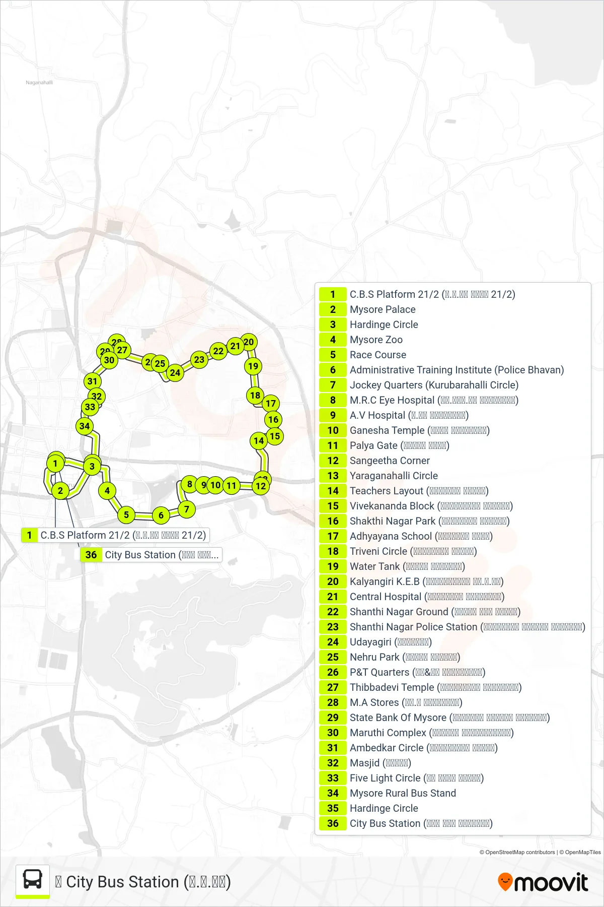
Stops list (200 - ↺ City Bus Station (ನ.ಬ.ನಿ))
- C.B.S Platform 21/2 (ನ.ಬ.ನಿ ಅಂಕಣ 21/2)
- Mysore Palace
- Hardinge Circle
- Mysore Zoo
- Race Course
- Administrative Training Institute (Police Bhavan)
- Jockey Quarters (Kurubarahalli Circle)
- M.R.C Eye Hospital (ಎಂ.ಆರ್.ಸಿ ನೇತ್ರಾಲಯ)
- A.V Hospital (ಎ.ವಿ ಆಸ್ಪತ್ರೆ)
- Ganesha Temple (ಗಣೇಶ ದೇವಸ್ಥಾನ)
- Palya Gate (ಪಾಳ್ಯ ಗೇಟ್)
- Sangeetha Corner
- Yaraganahalli Circle
- Teachers Layout (ಟೀಚರ್ಸ್ ಲೇಔಟ್)
- Vivekananda Block (ವಿವೇಕಾನಂದ ಬ್ಲಾಕ್)
- Shakthi Nagar Park (ಶಕ್ತಿನಗರ ಪಾರ್ಕ್)
- Adhyayana School (ಅಧ್ಯಾಯನ ಶಾಲೆ)
- Triveni Circle (ತ್ರಿವೇಣಿ ವೃತ್ತ)
- Water Tank (ವಾಟರ್ ಟ್ಯಾಂಕ್)
- Kalyangiri K.E.B (ಕಲ್ಯಾಣಗಿರಿ ಕೆ.ಇ.ಬಿ)
- Central Hospital (ಸೆಂಟ್ರಲ್ ಆಸ್ಪತ್ರೆ)
- Shanthi Nagar Ground (ಶಾಂತಿ ನಗರ ಮೈದಾನ)
- Shanthi Nagar Police Station (ಶಾಂತಿನಗರ ಪೋಲೀಸ್ ಸ್ಟೇಷನ್)
- Udayagiri (ಉದಯಗಿರಿ)
- Nehru Park (ನೆಹರೂ ಪಾರ್ಕ್)
- P&T Quarters (ಪಿ&ಟಿ ಕ್ವಾಟರ್ಸ್)
- Thibbadevi Temple (ತಿಬ್ಬದೇವಿ ದೇವಸ್ಥಾನ)
- M.A Stores (ಎಂ.ಎ ಸ್ಟೋರ್ಸ್)
- State Bank Of Mysore (ಮೈಸೂರಿನ ಸ್ಟೇಟ್ ಬ್ಯಾಂಕ್)
- Maruthi Complex (ಮಾರುತಿ ಕಾಂಪ್ಲೆಕ್ಸ್)
- Ambedkar Circle (ಅಂಬೇಡ್ಕರ್ ವೃತ್ತ)
- Masjid (ಮಸೀದಿ)
- Five Light Circle (ಫೈ ಲೈಟ್ ವೃತ್ತ)
- Mysore Rural Bus Stand
- Hardinge Circle
- City Bus Station (ನಗರ ಬಸ್ ನಿಲ್ದಾಣ)