
21 Bus Route Map
View the 21 route map and see all 21 stops along the route. The map of 21 shows where the bus travels and the location of each stop, making it easy to understand the entire route at a glance.
Explore TriMet routes on the map and see where TriMet bus services operate. Use the 21 map to find bus stops and see how the 21 connects different areas along its trip.
All 21 stops on the map are displayed in route order, helping you follow the 21 bus from the first stop to the last.
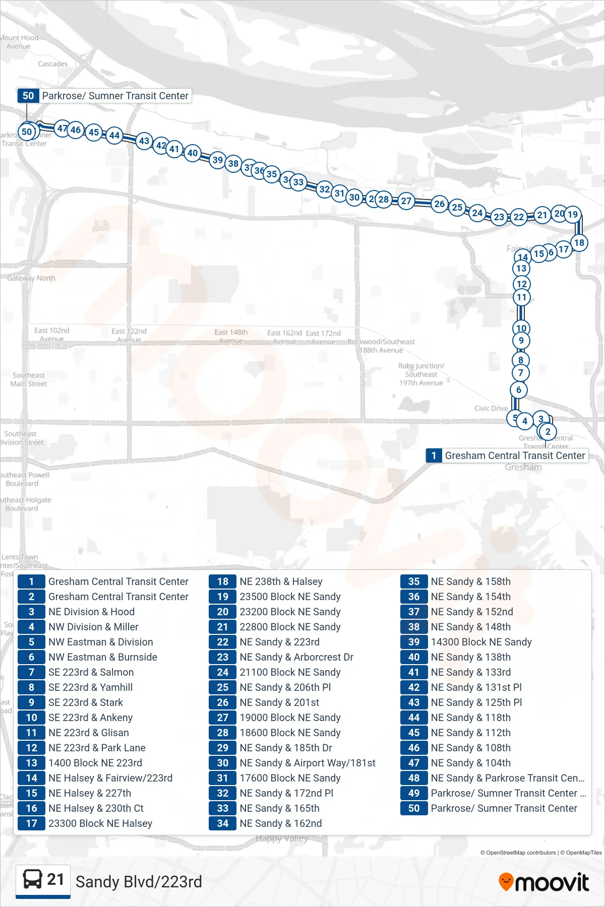
Stops list (21 - Parkrose/ Sumner Transit Center)
- Gresham Central Transit Center
- Gresham Central Transit Center
- NE Division & Hood
- NW Division & Miller
- NW Eastman & Division
- NW Eastman & Burnside
- SE 223rd & Salmon
- SE 223rd & Yamhill
- SE 223rd & Stark
- SE 223rd & Ankeny
- NE 223rd & Glisan
- NE 223rd & Park Lane
- 1400 Block NE 223rd
- NE Halsey & Fairview/223rd
- NE Halsey & 227th
- NE Halsey & 230th Ct
- 23300 Block NE Halsey
- NE 238th & Halsey
- 23500 Block NE Sandy
- 23200 Block NE Sandy
- 22800 Block NE Sandy
- NE Sandy & 223rd
- NE Sandy & Arborcrest Dr
- 21100 Block NE Sandy
- NE Sandy & 206th Pl
- NE Sandy & 201st
- 19000 Block NE Sandy
- 18600 Block NE Sandy
- NE Sandy & 185th Dr
- NE Sandy & Airport Way/181st
- 17600 Block NE Sandy
- NE Sandy & 172nd Pl
- NE Sandy & 165th
- NE Sandy & 162nd
- NE Sandy & 158th
- NE Sandy & 154th
- NE Sandy & 152nd
- NE Sandy & 148th
- 14300 Block NE Sandy
- NE Sandy & 138th
- NE Sandy & 133rd
- NE Sandy & 131st Pl
- NE Sandy & 125th Pl
- NE Sandy & 118th
- NE Sandy & 112th
- NE Sandy & 108th
- NE Sandy & 104th
- NE Sandy & Parkrose Transit Center
- Parkrose/ Sumner Transit Center (East)
- Parkrose/ Sumner Transit Center