
22 Bus Route Map
View the 22 route map and see all 22 stops along the route. The map of 22 shows where the bus travels and the location of each stop, making it easy to understand the entire route at a glance.
Explore Broward County Transit routes on the map and see where Broward County Transit bus services operate. Use the 22 map to find bus stops and see how the 22 connects different areas along its trip.
All 22 stops on the map are displayed in route order, helping you follow the 22 bus from the first stop to the last.
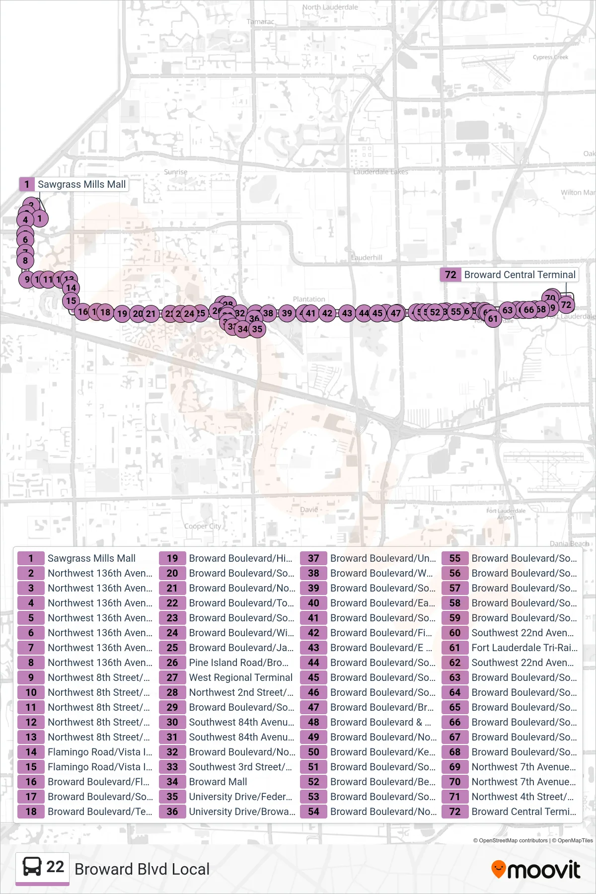
Stops list (22 - Central Terminal Via Westfield Mall & Tri-Rail)
- Sawgrass Mills Mall
- Northwest 136th Avenue/Red Snapper Road
- Northwest 136th Avenue/Northwest 22nd Place
- Northwest 136th Avenue/Northwest 21st Street
- Northwest 136th Avenue/Sunrise Boulevard
- Northwest 136th Avenue/RACAL
- Northwest 136th Avenue/Northwest 14th Street
- Northwest 136th Avenue/Northwest 12th Street
- Northwest 8th Street/Northwest 136th Avenue
- Northwest 8th Street/Northwest 133rd Avenue
- Northwest 8th Street/Commodore Drive
- Northwest 8th Street/Key Lime Way
- Northwest 8th Street/Flamingo Road
- Flamingo Road/Vista Isles Drive - (Flamingo K)
- Flamingo Road/Vista Isles Drive
- Broward Boulevard/Flamingo Road - (American Heritage School)
- Broward Boulevard/Southwest 118th Avenue
- Broward Boulevard/Terra Bella
- Broward Boulevard/Hiatus Road
- Broward Boulevard/Southwest 108th Avenue
- Broward Boulevard/Nob Hill Road
- Broward Boulevard/Torchwood Avenue
- Broward Boulevard/Southwest 96th Terrace
- Broward Boulevard/Wimbledon Lake Drive
- Broward Boulevard/Jacaranda Country Club Drive
- Pine Island Road/Broward Boulevard
- West Regional Terminal
- Northwest 2nd Street/Northwest 84th Avenue
- Broward Boulevard/Southwest 84th Avenue
- Southwest 84th Avenue/Broward Boulevard
- Southwest 84th Avenue/Southwest 2nd Street
- Broward Boulevard/Northwest 82nd Avenue - (Executive Pavilion West)
- Southwest 3rd Street/Southwest 82nd Avenue (Fire Department)
- Broward Mall
- University Drive/Federated Road
- University Drive/Broward Boulevard
- Broward Boulevard/University Drive
- Broward Boulevard/West Tropical Way
- Broward Boulevard/Southwest 70th Terrace
- Broward Boulevard/East Tropical Way
- Broward Boulevard/Southwest 63rd Avenue
- Broward Boulevard/Fig Tree Lane
- Broward Boulevard/E Acre Drive
- Broward Boulevard/Southwest 48th Avenue
- Broward Boulevard/Southwest 46th Avenue
- Broward Boulevard/Southwest 44th Avenue
- Broward Boulevard/Bryan Boulevard
- Broward Boulevard & US 441
- Broward Boulevard/Northwest 36th Avenue
- Broward Boulevard/Kentucky Avenue
- Broward Boulevard/Southwest 34th Avenue
- Broward Boulevard/Berkeley Boulevard
- Broward Boulevard/Southwest 31st Avenue
- Broward Boulevard/Northwest 31st Avenue
- Broward Boulevard/Southwest 29th Avenue
- Broward Boulevard/Southwest 28th Avenue
- Broward Boulevard/Southwest 27th Avenue
- Broward Boulevard/Southwest 26th Avenue
- Broward Boulevard/Southwest 22nd Avenue
- Southwest 22nd Avenue/Southwest 1st Street
- Fort Lauderdale Tri-Rail Station
- Southwest 22nd Avenue/Southwest 1st Street - (Park & Ride)
- Broward Boulevard/Southwest 18th Avenue
- Broward Boulevard/Southwest 15th Avenue
- Broward Boulevard/Southwest 14th Avenue (Police Department)
- Broward Boulevard/Southwest 12th Avenue
- Broward Boulevard/Southwest 11th Avenue
- Broward Boulevard/Southwest 9th Avenue
- Northwest 7th Avenue/Broward Boulevard
- Northwest 7th Avenue/Northwest 4th Street (Family Health Center)
- Northwest 4th Street/Northwest 6th Avenue (Family Health Center)
- Broward Central Terminal
Change direction
- Route Map - 22 - Central Terminal
- Route Map - 22 - Central Terminal Via Tri-Rail
- Route Map - 22 - Sawgrass Mills Via Tri-Rail
- Route Map - 22 - West Terminal Via Westfield Mall
- Route Map - 22 - West Terminal Via Tri-Rail
- Route Map - 22 - Sawgrass Mills Via Westfield Mall
- Route Map - 22 - West Terminal
- Route Map - 22 - Sawgrass Mills