
240 Bus Route Map
View the 240 route map and see all 240 stops along the route. The map of 240 shows where the bus travels and the location of each stop, making it easy to understand the entire route at a glance.
Explore RAB routes on the map and see where RAB bus services operate. Use the 240 map to find bus stops and see how the 240 connects different areas along its trip.
All 240 stops on the map are displayed in route order, helping you follow the 240 bus from the first stop to the last.
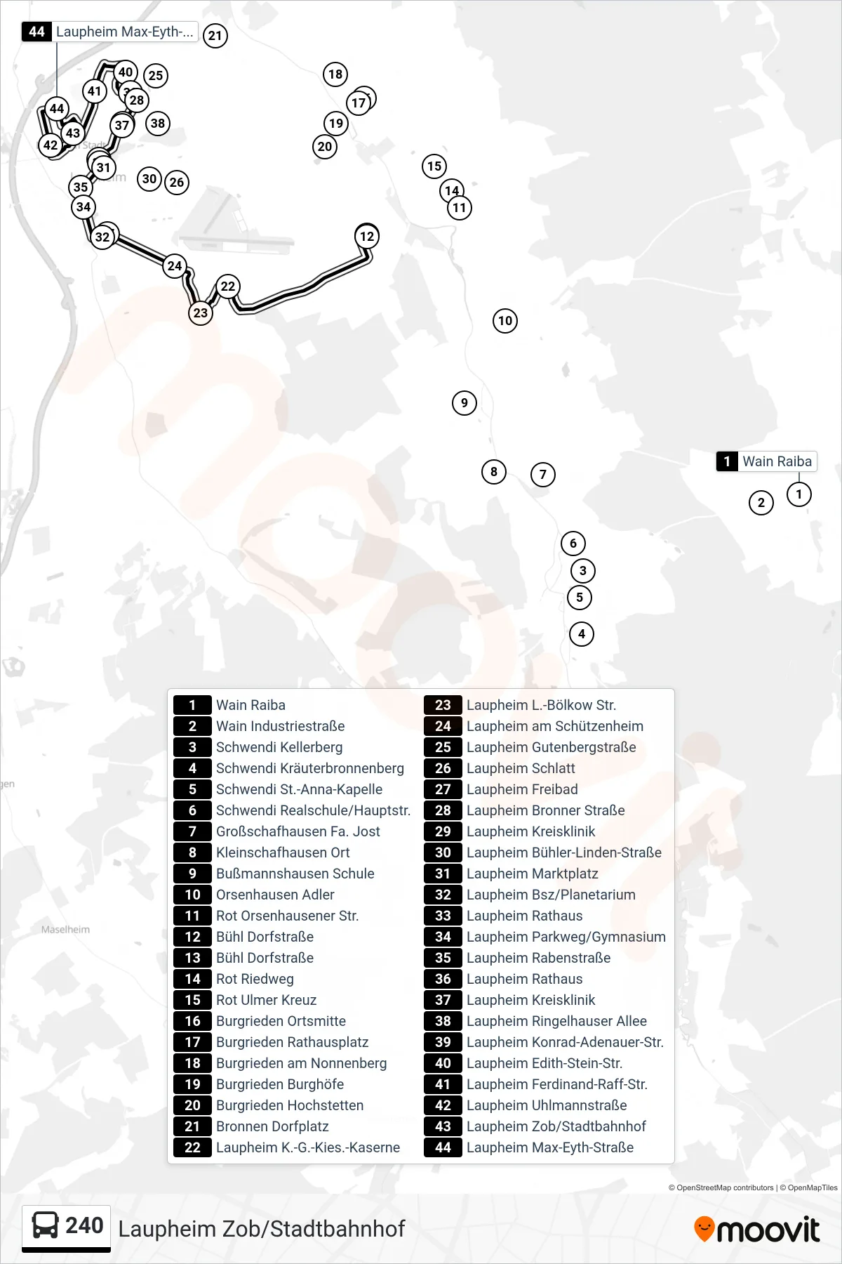
Stops list (240 - Laupheim Zob/Stadtbahnhof)
- Wain Raiba
- Wain Industriestraße
- Schwendi Kellerberg
- Schwendi Kräuterbronnenberg
- Schwendi St.-Anna-Kapelle
- Schwendi Realschule/Hauptstr.
- Großschafhausen Fa. Jost
- Kleinschafhausen Ort
- Bußmannshausen Schule
- Orsenhausen Adler
- Rot Orsenhausener Str.
- Bühl Dorfstraße
- Bühl Dorfstraße
- Rot Riedweg
- Rot Ulmer Kreuz
- Burgrieden Ortsmitte
- Burgrieden Rathausplatz
- Burgrieden am Nonnenberg
- Burgrieden Burghöfe
- Burgrieden Hochstetten
- Bronnen Dorfplatz
- Laupheim K.-G.-Kies.-Kaserne
- Laupheim L.-Bölkow Str.
- Laupheim am Schützenheim
- Laupheim Gutenbergstraße
- Laupheim Schlatt
- Laupheim Freibad
- Laupheim Bronner Straße
- Laupheim Kreisklinik
- Laupheim Bühler-Linden-Straße
- Laupheim Marktplatz
- Laupheim Bsz/Planetarium
- Laupheim Rathaus
- Laupheim Parkweg/Gymnasium
- Laupheim Rabenstraße
- Laupheim Rathaus
- Laupheim Kreisklinik
- Laupheim Ringelhauser Allee
- Laupheim Konrad-Adenauer-Str.
- Laupheim Edith-Stein-Str.
- Laupheim Ferdinand-Raff-Str.
- Laupheim Uhlmannstraße
- Laupheim Zob/Stadtbahnhof
- Laupheim Max-Eyth-Straße
Change direction
- Route Map - 240 - Laupheim K.-G.-Kies.-Kaserne
- Route Map - 240 - Laupheim Westbahnhof
- Route Map - 240 - Burgrieden Rathausplatz
- Route Map - 240 - Rot Ulmer Kreuz
- Route Map - 240 - Laupheim Rabenstraße
- Route Map - 240 - Laupheim Rabenstraße
- Route Map - 240 - Bühl Dorfstraße
- Route Map - 240 - Burgrieden am Nonnenberg
- Route Map - 240 - Laupheim Max-Eyth-Straße
- Route Map - 240 - Wain Schloß
- Route Map - 240 - Weihungszell Mühle