
29 Bus Route Map
View the 29 route map and see all 29 stops along the route. The map of 29 shows where the bus travels and the location of each stop, making it easy to understand the entire route at a glance.
Explore Space Coast Area Transit routes on the map and see where Space Coast Area Transit bus services operate. Use the 29 map to find bus stops and see how the 29 connects different areas along its trip.
All 29 stops on the map are displayed in route order, helping you follow the 29 bus from the first stop to the last.
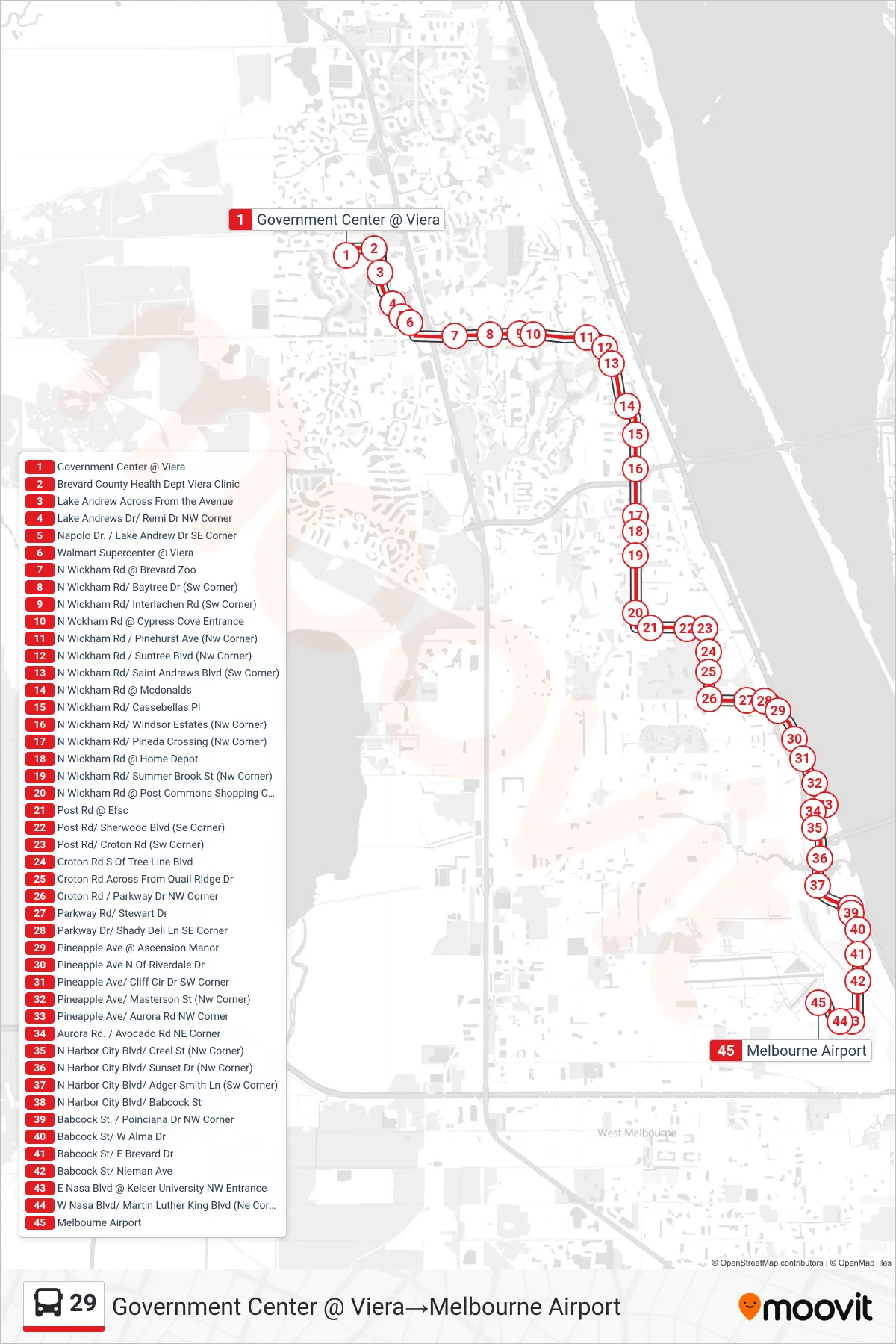
Stops list (29 - Government Center @ Viera→Melbourne Airport)
- Government Center @ Viera
- Brevard County Health Dept Viera Clinic
- Lake Andrew Across From the Avenue
- Lake Andrews Dr/ Remi Dr NW Corner
- Napolo Dr. / Lake Andrew Dr SE Corner
- Walmart Supercenter @ Viera
- N Wickham Rd @ Brevard Zoo
- N Wickham Rd/ Baytree Dr (Sw Corner)
- N Wickham Rd/ Interlachen Rd (Sw Corner)
- N Wckham Rd @ Cypress Cove Entrance
- N Wickham Rd / Pinehurst Ave (Nw Corner)
- N Wickham Rd / Suntree Blvd (Nw Corner)
- N Wickham Rd/ Saint Andrews Blvd (Sw Corner)
- N Wickham Rd @ Mcdonalds
- N Wickham Rd/ Cassebellas Pl
- N Wickham Rd/ Windsor Estates (Nw Corner)
- N Wickham Rd/ Pineda Crossing (Nw Corner)
- N Wickham Rd @ Home Depot
- N Wickham Rd/ Summer Brook St (Nw Corner)
- N Wickham Rd @ Post Commons Shopping Center
- Post Rd @ Efsc
- Post Rd/ Sherwood Blvd (Se Corner)
- Post Rd/ Croton Rd (Sw Corner)
- Croton Rd S Of Tree Line Blvd
- Croton Rd Across From Quail Ridge Dr
- Croton Rd / Parkway Dr NW Corner
- Parkway Rd/ Stewart Dr
- Parkway Dr/ Shady Dell Ln SE Corner
- Pineapple Ave @ Ascension Manor
- Pineapple Ave N Of Riverdale Dr
- Pineapple Ave/ Cliff Cir Dr SW Corner
- Pineapple Ave/ Masterson St (Nw Corner)
- Pineapple Ave/ Aurora Rd NW Corner
- Aurora Rd. / Avocado Rd NE Corner
- N Harbor City Blvd/ Creel St (Nw Corner)
- N Harbor City Blvd/ Sunset Dr (Nw Corner)
- N Harbor City Blvd/ Adger Smith Ln (Sw Corner)
- N Harbor City Blvd/ Babcock St
- Babcock St. / Poinciana Dr NW Corner
- Babcock St/ W Alma Dr
- Babcock St/ E Brevard Dr
- Babcock St/ Nieman Ave
- E Nasa Blvd @ Keiser University NW Entrance
- W Nasa Blvd/ Martin Luther King Blvd (Ne Corner)
- Melbourne Airport
Change direction
- Route Map - 29 - Melbourne Airport→Viera Regional Park
- Route Map - 29 - Melbourne Airport→Nasa Blvd @ Babcock St
- Route Map - 29 - Viera Regional Park→Melbourne Airport
- Route Map - 29 - Palm Bay West Shopping Center→Government Center @ Viera
- Route Map - 29 - Melbourne Airport→Government Center @ Viera