
301 Tram Route Map
View the 301 route map and see all 301 stops along the route. The map of 301 shows where the tram travels and the location of each stop, making it easy to understand the entire route at a glance.
Explore routes on the map and see where tram services operate. Use the 301 map to find tram stations and see how the 301 connects different areas along its trip.
All 301 stops on the map are displayed in route order, helping you follow the 301 tram from the first station to the last.
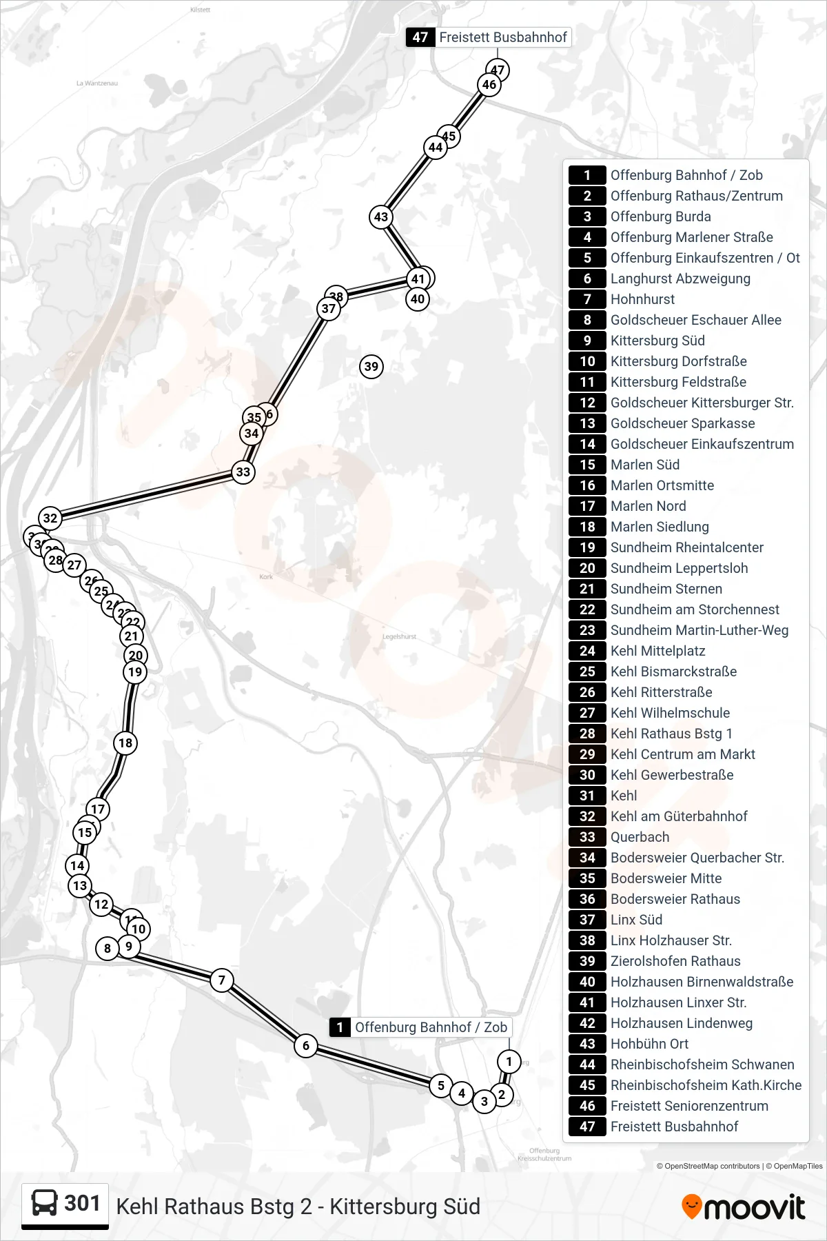
Stops list (301 - Freistett Busbahnhof)
- Offenburg Bahnhof / Zob
- Offenburg Rathaus/Zentrum
- Offenburg Burda
- Offenburg Marlener Straße
- Offenburg Einkaufszentren / Ot
- Langhurst Abzweigung
- Hohnhurst
- Goldscheuer Eschauer Allee
- Kittersburg Süd
- Kittersburg Dorfstraße
- Kittersburg Feldstraße
- Goldscheuer Kittersburger Str.
- Goldscheuer Sparkasse
- Goldscheuer Einkaufszentrum
- Marlen Süd
- Marlen Ortsmitte
- Marlen Nord
- Marlen Siedlung
- Sundheim Rheintalcenter
- Sundheim Leppertsloh
- Sundheim Sternen
- Sundheim am Storchennest
- Sundheim Martin-Luther-Weg
- Kehl Mittelplatz
- Kehl Bismarckstraße
- Kehl Ritterstraße
- Kehl Wilhelmschule
- Kehl Rathaus Bstg 1
- Kehl Centrum am Markt
- Kehl Gewerbestraße
- Kehl
- Kehl am Güterbahnhof
- Querbach
- Bodersweier Querbacher Str.
- Bodersweier Mitte
- Bodersweier Rathaus
- Linx Süd
- Linx Holzhauser Str.
- Zierolshofen Rathaus
- Holzhausen Birnenwaldstraße
- Holzhausen Linxer Str.
- Holzhausen Lindenweg
- Hohbühn Ort
- Rheinbischofsheim Schwanen
- Rheinbischofsheim Kath.Kirche
- Freistett Seniorenzentrum
- Freistett Busbahnhof
Change direction
- Route Map - 301 - Kehl Rathaus
- Route Map - 301 - Kehl Rathaus
- Route Map - 301 - Offenburg Bahnhof / Zob
- Route Map - 301 - Offenburg Schulztr. Nord
- Route Map - 301 - Bodersweier Rathaus
- Route Map - 301 - Kittersburg Süd
- Route Map - 301 - Rheinbischofsheim Schwanen
- Route Map - 301 - Hohnhurst
- Route Map - 301 - Hohbühn Süd
- Route Map - 301 - Zierolshofen Rathaus
- Route Map - 301 - Goldscheuer Gewerbegeb. Basic
- Route Map - 301 - Bodersweier Querbacher Str.