
330 Bus Route Map
View the 330 route map and see all 330 stops along the route. The map of 330 shows where the bus travels and the location of each stop, making it easy to understand the entire route at a glance.
Explore BW routes on the map and see where BW bus services operate. Use the 330 map to find bus stops and see how the 330 connects different areas along its trip.
All 330 stops on the map are displayed in route order, helping you follow the 330 bus from the first stop to the last.
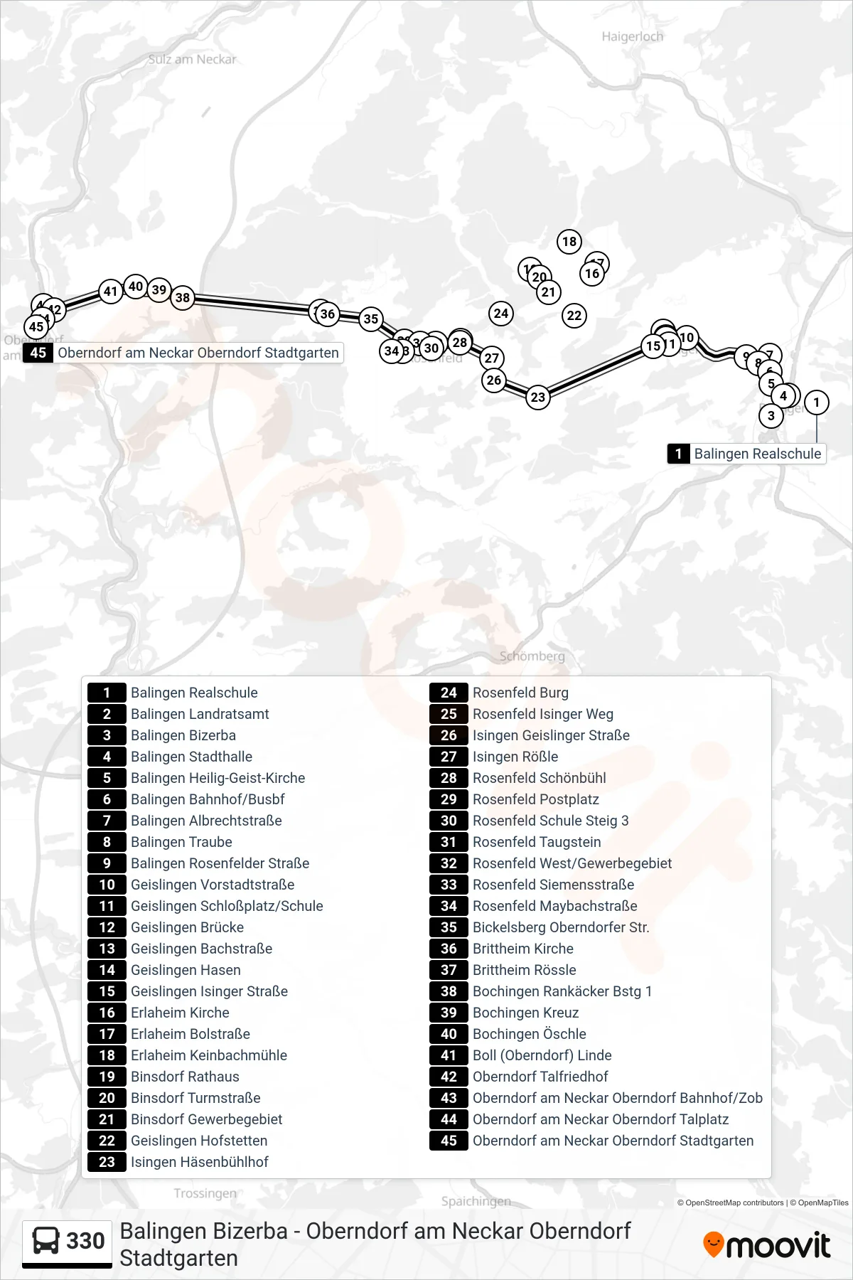
Stops list (330 - Oberndorf am Neckar Oberndorf Stadtgarten)
- Balingen Realschule
- Balingen Landratsamt
- Balingen Bizerba
- Balingen Stadthalle
- Balingen Heilig-Geist-Kirche
- Balingen Bahnhof/Busbf
- Balingen Albrechtstraße
- Balingen Traube
- Balingen Rosenfelder Straße
- Geislingen Vorstadtstraße
- Geislingen Schloßplatz/Schule
- Geislingen Brücke
- Geislingen Bachstraße
- Geislingen Hasen
- Geislingen Isinger Straße
- Erlaheim Kirche
- Erlaheim Bolstraße
- Erlaheim Keinbachmühle
- Binsdorf Rathaus
- Binsdorf Turmstraße
- Binsdorf Gewerbegebiet
- Geislingen Hofstetten
- Isingen Häsenbühlhof
- Rosenfeld Burg
- Rosenfeld Isinger Weg
- Isingen Geislinger Straße
- Isingen Rößle
- Rosenfeld Schönbühl
- Rosenfeld Postplatz
- Rosenfeld Schule Steig 3
- Rosenfeld Taugstein
- Rosenfeld West/Gewerbegebiet
- Rosenfeld Siemensstraße
- Rosenfeld Maybachstraße
- Bickelsberg Oberndorfer Str.
- Brittheim Kirche
- Brittheim Rössle
- Bochingen Rankäcker Bstg 1
- Bochingen Kreuz
- Bochingen Öschle
- Boll (Oberndorf) Linde
- Oberndorf Talfriedhof
- Oberndorf am Neckar Oberndorf Bahnhof/Zob
- Oberndorf am Neckar Oberndorf Talplatz
- Oberndorf am Neckar Oberndorf Stadtgarten
Change direction
- Route Map - 330 - Rosenfeld Lindenstraße
- Route Map - 330 - Geislingen Hofstetten
- Route Map - 330 - Binsdorf Rathaus
- Route Map - 330 - Geislingen Hasen
- Route Map - 330 - Rosenfeld Schule
- Route Map - 330 - Geislingen Vorstadtstraße
- Route Map - 330 - Rosenfeld Postplatz
- Route Map - 330 - Rosenfeld Postplatz
- Route Map - 330 - Heiligenzimmern Rathaus
- Route Map - 330 - Balingen Realschule
- Route Map - 330 - Brittheim Rössle
- Route Map - 330 - Balingen Bahnhof/Busbf
- Route Map - 330 - Rosenfeld West/Gewerbegebiet
- Route Map - 330 - Balingen Bizerba
- Route Map - 330 - Balingen City-Center