
4 Bus Route Map
View the 4 route map and see all 4 stops along the route. The map of 4 shows where the bus travels and the location of each stop, making it easy to understand the entire route at a glance.
Explore Midttrafik routes on the map and see where Midttrafik bus services operate. Use the 4 map to find bus stops and see how the 4 connects different areas along its trip.
All 4 stops on the map are displayed in route order, helping you follow the 4 bus from the first stop to the last.
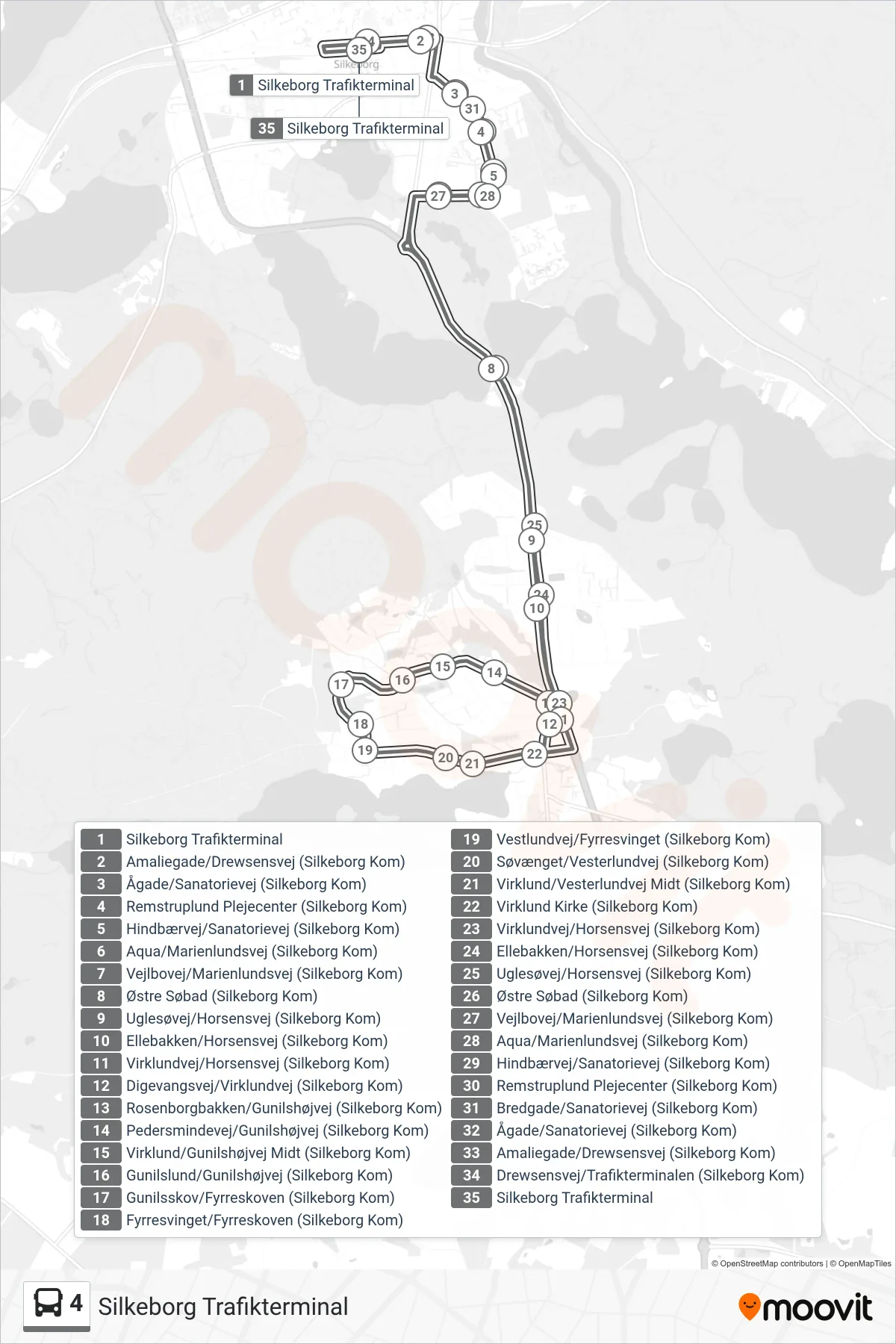
Stops list (4 - Silkeborg Trafikterminal)
- Silkeborg Trafikterminal
- Amaliegade/Drewsensvej (Silkeborg Kom)
- Ågade/Sanatorievej (Silkeborg Kom)
- Remstruplund Plejecenter (Silkeborg Kom)
- Hindbærvej/Sanatorievej (Silkeborg Kom)
- Aqua/Marienlundsvej (Silkeborg Kom)
- Vejlbovej/Marienlundsvej (Silkeborg Kom)
- Østre Søbad (Silkeborg Kom)
- Uglesøvej/Horsensvej (Silkeborg Kom)
- Ellebakken/Horsensvej (Silkeborg Kom)
- Virklundvej/Horsensvej (Silkeborg Kom)
- Digevangsvej/Virklundvej (Silkeborg Kom)
- Rosenborgbakken/Gunilshøjvej (Silkeborg Kom)
- Pedersmindevej/Gunilshøjvej (Silkeborg Kom)
- Virklund/Gunilshøjvej Midt (Silkeborg Kom)
- Gunilslund/Gunilshøjvej (Silkeborg Kom)
- Gunilsskov/Fyrreskoven (Silkeborg Kom)
- Fyrresvinget/Fyrreskoven (Silkeborg Kom)
- Vestlundvej/Fyrresvinget (Silkeborg Kom)
- Søvænget/Vesterlundvej (Silkeborg Kom)
- Virklund/Vesterlundvej Midt (Silkeborg Kom)
- Virklund Kirke (Silkeborg Kom)
- Virklundvej/Horsensvej (Silkeborg Kom)
- Ellebakken/Horsensvej (Silkeborg Kom)
- Uglesøvej/Horsensvej (Silkeborg Kom)
- Østre Søbad (Silkeborg Kom)
- Vejlbovej/Marienlundsvej (Silkeborg Kom)
- Aqua/Marienlundsvej (Silkeborg Kom)
- Hindbærvej/Sanatorievej (Silkeborg Kom)
- Remstruplund Plejecenter (Silkeborg Kom)
- Bredgade/Sanatorievej (Silkeborg Kom)
- Ågade/Sanatorievej (Silkeborg Kom)
- Amaliegade/Drewsensvej (Silkeborg Kom)
- Drewsensvej/Trafikterminalen (Silkeborg Kom)
- Silkeborg Trafikterminal