
42 Bus Route Map
View the 42 route map and see all 42 stops along the route. The map of 42 shows where the bus travels and the location of each stop, making it easy to understand the entire route at a glance.
Explore Aachener Straßenbahn- und Energieversorgungs-AG routes on the map and see where Aachener Straßenbahn- und Energieversorgungs-AG bus services operate. Use the 42 map to find bus stops and see how the 42 connects different areas along its trip.
All 42 stops on the map are displayed in route order, helping you follow the 42 bus from the first stop to the last.
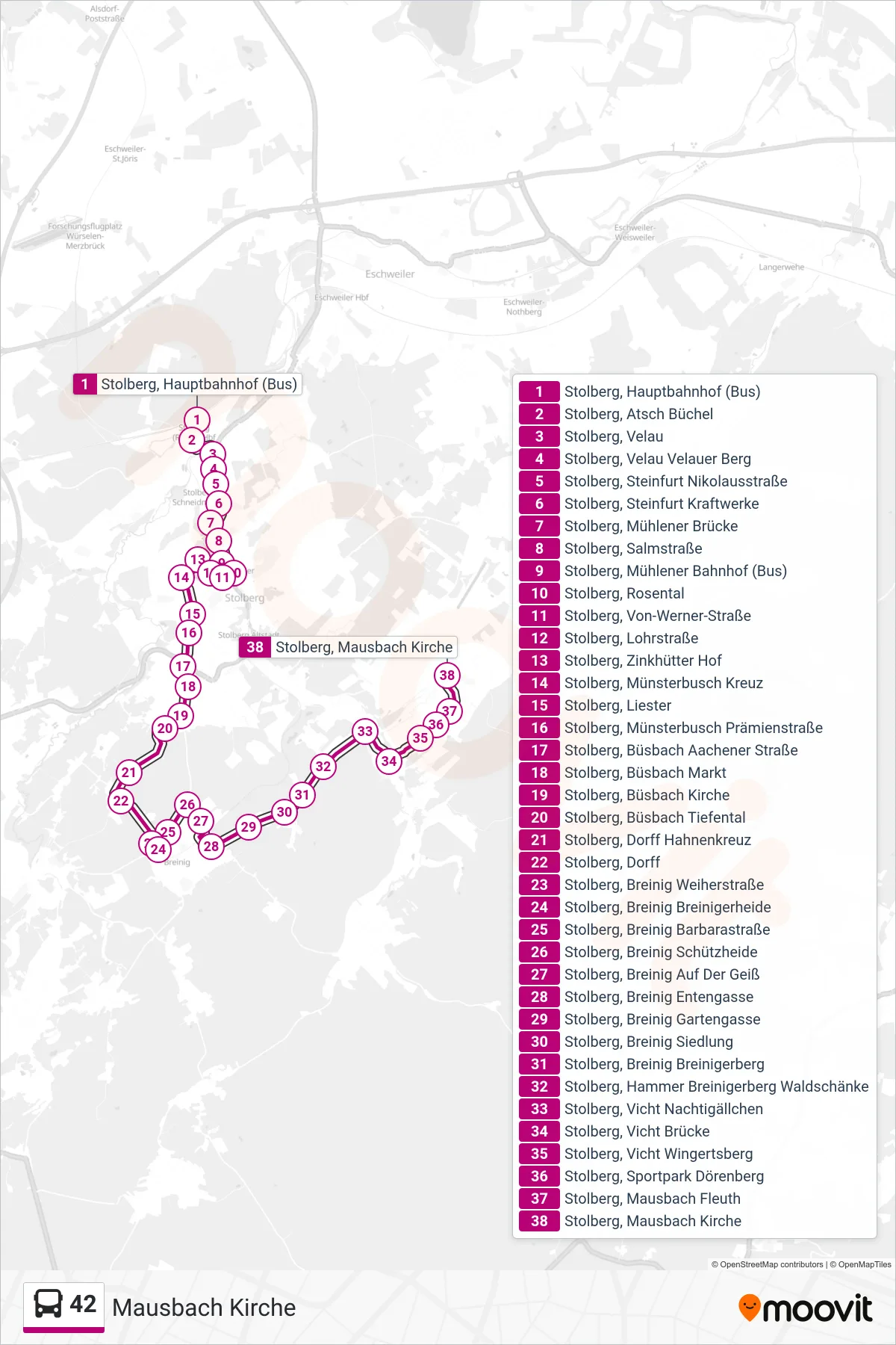
Stops list (42 - Mausbach Kirche)
- Stolberg, Hauptbahnhof (Bus)
- Stolberg, Atsch Büchel
- Stolberg, Velau
- Stolberg, Velau Velauer Berg
- Stolberg, Steinfurt Nikolausstraße
- Stolberg, Steinfurt Kraftwerke
- Stolberg, Mühlener Brücke
- Stolberg, Salmstraße
- Stolberg, Mühlener Bahnhof (Bus)
- Stolberg, Rosental
- Stolberg, Von-Werner-Straße
- Stolberg, Lohrstraße
- Stolberg, Zinkhütter Hof
- Stolberg, Münsterbusch Kreuz
- Stolberg, Liester
- Stolberg, Münsterbusch Prämienstraße
- Stolberg, Büsbach Aachener Straße
- Stolberg, Büsbach Markt
- Stolberg, Büsbach Kirche
- Stolberg, Büsbach Tiefental
- Stolberg, Dorff Hahnenkreuz
- Stolberg, Dorff
- Stolberg, Breinig Weiherstraße
- Stolberg, Breinig Breinigerheide
- Stolberg, Breinig Barbarastraße
- Stolberg, Breinig Schützheide
- Stolberg, Breinig Auf Der Geiß
- Stolberg, Breinig Entengasse
- Stolberg, Breinig Gartengasse
- Stolberg, Breinig Siedlung
- Stolberg, Breinig Breinigerberg
- Stolberg, Hammer Breinigerberg Waldschänke
- Stolberg, Vicht Nachtigällchen
- Stolberg, Vicht Brücke
- Stolberg, Vicht Wingertsberg
- Stolberg, Sportpark Dörenberg
- Stolberg, Mausbach Fleuth
- Stolberg, Mausbach Kirche
Change direction
- Route Map - 42 - Stolberg Mühlener Bf. (Atsch)
- Route Map - 42 - Stolberg Hauptbahnhof
- Route Map - 42 - Gressenich Kapelle
- Route Map - 42 - Stolberg Mühlener Bahnhof (Weiter Als Li. 22)
- Route Map - 42 - Stolberg Mühlener Bahnhof (Weiter Als Li. 12)
- Route Map - 42 - Stolberg Hans-Böckler-Straße
- Route Map - 42 - Vicht Brücke
- Route Map - 42 - Mausbach Kirche
- Route Map - 42 - Stolberg Mühlener Bahnhof
- Route Map - 42 - Breinigerberg
- Route Map - 42 - Zweifall Solchbachtal
- Route Map - 42 - Stolberg, Vicht Derichsberg
- Route Map - 42 - Gressenich Kapelle (Weiter Als Li. Ew1)