
44 Bus Route Map
View the 44 route map and see all 44 stops along the route. The map of 44 shows where the bus travels and the location of each stop, making it easy to understand the entire route at a glance.
Explore ATMA S.c.p.a. routes on the map and see where ATMA S.c.p.a. bus services operate. Use the 44 map to find bus stops and see how the 44 connects different areas along its trip.
All 44 stops on the map are displayed in route order, helping you follow the 44 bus from the first stop to the last.
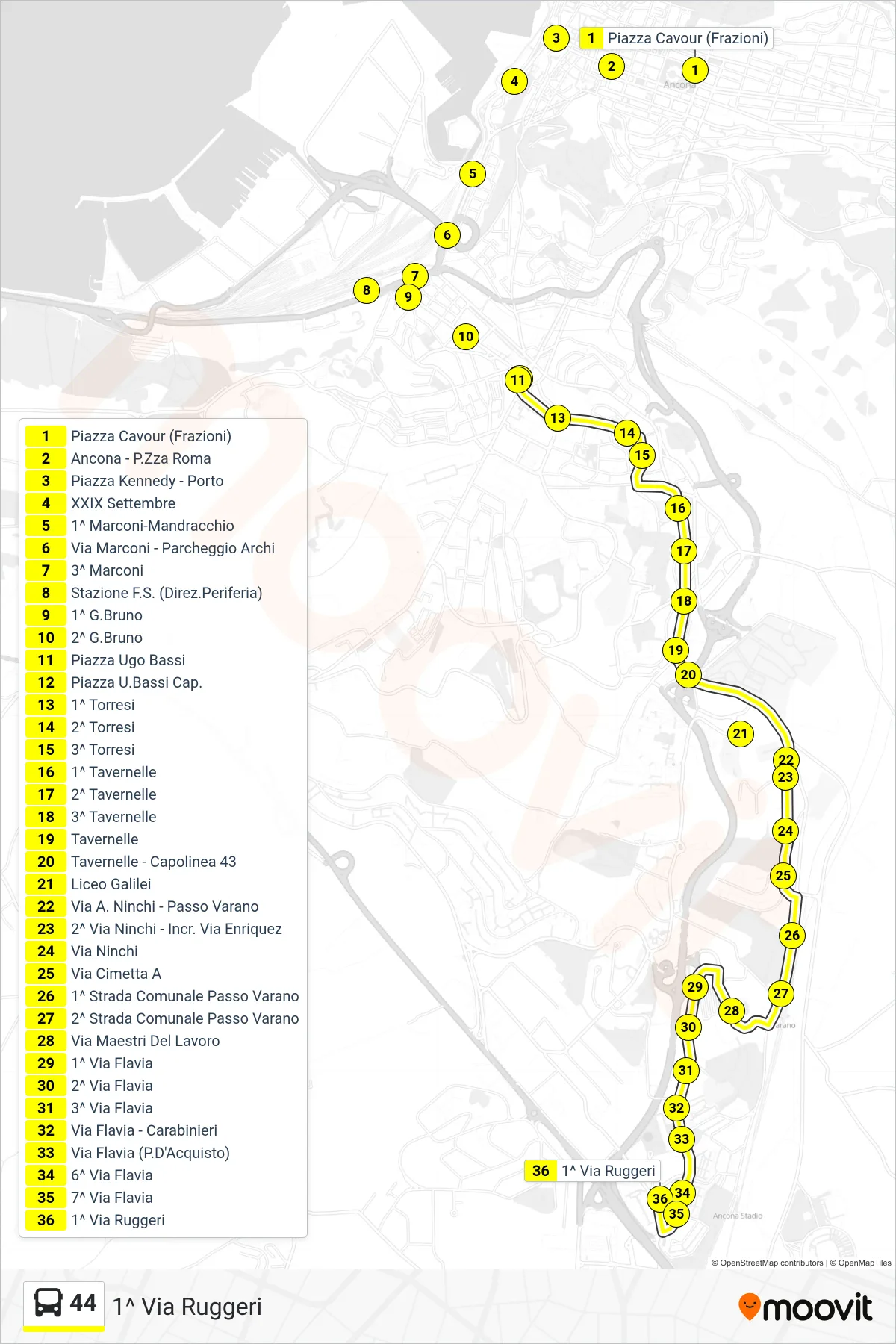
Stops list (44 - 1st Ruggeri Street)
- Piazza Cavour (Districts)
- Ancona - Roma Square
- Kennedy Square - Port
- XXIX September
- 1st Marconi-Mandracchio
- Via Marconi - Archi Parking
- 3rd Marconi
- Railway Station (Outbound)
- 1st G.Bruno
- 2nd G.Bruno
- Ugo Bassi Square
- Piazza U.Bassi Terminal
- 1st Torresi
- 2nd Torresi
- 3rd Torresi
- 1st Tavernelle
- 2nd Tavernelle
- 3rd Tavernelle
- Tavernelle
- Tavernelle - Line 43 Terminal
- Galilei High School
- A. Ninchi Street - Passo Varano
- 2nd Ninchi Street - Enriquez Street Junction
- Ninchi Street
- Via Cimetta Inbound
- 1st Municipal Road Passo Varano
- 2nd Municipal Road Passo Varano
- Masters of Labor Street
- 1st Via Flavia
- 2nd Flavia Street
- 3rd Via Flavia
- Via Flavia - Carabinieri
- Via Flavia (P. D'Acquisto)
- 6th Flavia Street
- 7th Via Flavia
- 1st Ruggeri Street
Change direction
- Route Map - 44 - Podesti Institute
- Route Map - 44 - Technical Industrial Institute
- Route Map - 44 - Via Togliatti - Istvas
- Route Map - 44 - Piazza U.Bassi Terminal
- Route Map - 44 - Piazza Cavour (Districts)
- Route Map - 44 - Palarossini (Parking)
- Route Map - 44 - Train Station (Cap. 44)
- Route Map - 44 - Tavernelle Terminal
- Route Map - 44 - Via Scataglini - Shopping Center
- Route Map - 44 - Palarossini (Parking)
- Route Map - 44 - Railway Station (To Center)