
481 Bus Route Map
View the 481 route map and see all 481 stops along the route. The map of 481 shows where the bus travels and the location of each stop, making it easy to understand the entire route at a glance.
Explore ww mobility GmbH routes on the map and see where ww mobility GmbH bus services operate. Use the 481 map to find bus stops and see how the 481 connects different areas along its trip.
All 481 stops on the map are displayed in route order, helping you follow the 481 bus from the first stop to the last.
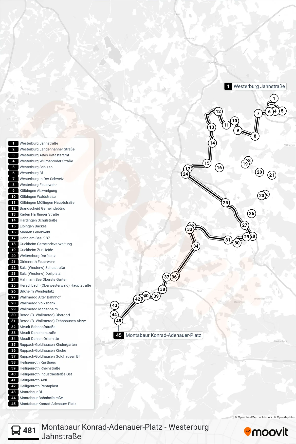
Stops list (481 - Montabaur Konrad-Adenauer-Platz)
- Westerburg Jahnstraße
- Westerburg Langenhahner Straße
- Westerburg Altes Katasteramt
- Westerburg Willmenroder Straße
- Westerburg Schulen
- Westerburg Bf
- Westerburg In Der Schweiz
- Westerburg Feuerwehr
- Kölbingen Abzweigung
- Kölbingen Waldstraße
- Kölbingen Möllingen Hauptstraße
- Brandscheid Gemeindebüro
- Kaden Härtlinger Straße
- Härtlingen Schulstraße
- Elbingen Backes
- Mähren Feuerwehr
- Hahn am See K 87
- Guckheim Gemeindeverwaltung
- Guckheim Zur Heide
- Weltersburg Dorfplatz
- Girkenroth Feuerwehr
- Salz (Westerw) Schulstraße
- Salz (Westerw) Dorfplatz
- Hahn am See Oberste Garten
- Herschbach (Oberwesterwald) Hauptstraße
- Bilkheim Wendeplatz
- Wallmerod Alter Bahnhof
- Wallmerod Volksbank
- Wallmerod Marienheim
- Berod (B. Wallmerod) Oberdorf
- Berod (B. Wallmerod) Zehnhausen Abzw.
- Meudt Bahnhofstraße
- Meudt Dahlenerstraße
- Meudt Dahlen Ortsmitte
- Ruppach-Goldhausen Kindergarten
- Ruppach-Goldhausen Kirche
- Ruppach-Goldhausen Goldhausen Bf
- Heiligenroth Rasthaus
- Heiligenroth Rheinstraße
- Heiligenroth Industriestraße Ost
- Heiligenroth Aldi
- Heiligenroth Pentaplast
- Montabaur Bf
- Montabaur Bahnhofstraße
- Montabaur Konrad-Adenauer-Platz
Change direction
- Route Map - 481 - Westerburg Jahnstraße
- Route Map - 481 - Berzhahn Ortsmitte
- Route Map - 481 - Montabaur Bf
- Route Map - 481 - Niedersayn Haus Schmidt
- Route Map - 481 - Hahn am See Oberste Garten
- Route Map - 481 - Kuhnhöfen Bachstraße
- Route Map - 481 - Montabaur Kreishaus
- Route Map - 481 - Wallmerod Volksbank
- Route Map - 481 - Westerburg Schulen