
491 Bus Route Map
View the 491 route map and see all 491 stops along the route. The map of 491 shows where the bus travels and the location of each stop, making it easy to understand the entire route at a glance.
Explore ALV Marburg routes on the map and see where ALV Marburg bus services operate. Use the 491 map to find bus stops and see how the 491 connects different areas along its trip.
All 491 stops on the map are displayed in route order, helping you follow the 491 bus from the first stop to the last.
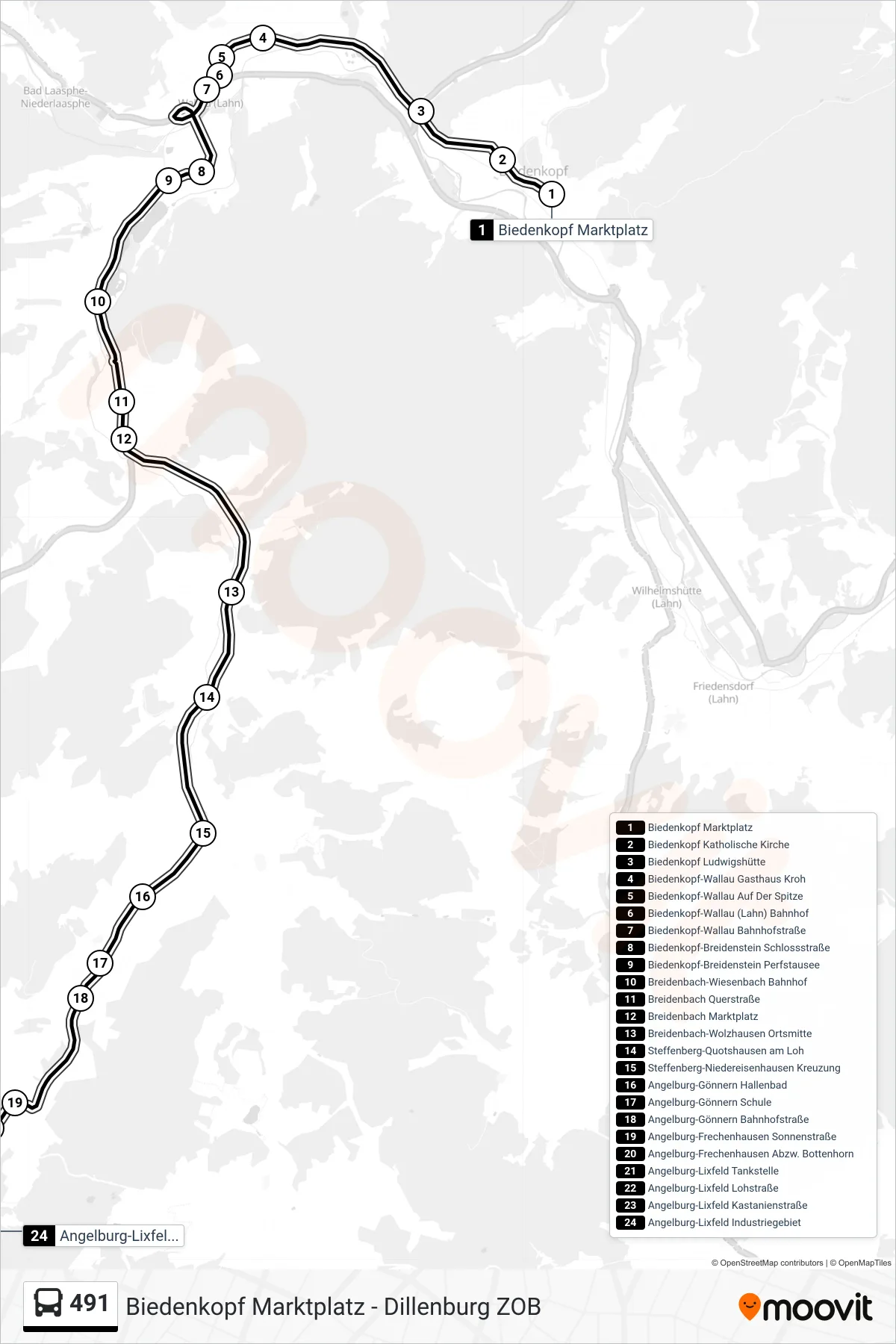
Stops list (491 - Angelburg-Lixfeld Industriegebiet)
- Biedenkopf Marktplatz
- Biedenkopf Katholische Kirche
- Biedenkopf Ludwigshütte
- Biedenkopf-Wallau Gasthaus Kroh
- Biedenkopf-Wallau Auf Der Spitze
- Biedenkopf-Wallau (Lahn) Bahnhof
- Biedenkopf-Wallau Bahnhofstraße
- Biedenkopf-Breidenstein Schlossstraße
- Biedenkopf-Breidenstein Perfstausee
- Breidenbach-Wiesenbach Bahnhof
- Breidenbach Querstraße
- Breidenbach Marktplatz
- Breidenbach-Wolzhausen Ortsmitte
- Steffenberg-Quotshausen am Loh
- Steffenberg-Niedereisenhausen Kreuzung
- Angelburg-Gönnern Hallenbad
- Angelburg-Gönnern Schule
- Angelburg-Gönnern Bahnhofstraße
- Angelburg-Frechenhausen Sonnenstraße
- Angelburg-Frechenhausen Abzw. Bottenhorn
- Angelburg-Lixfeld Tankstelle
- Angelburg-Lixfeld Lohstraße
- Angelburg-Lixfeld Kastanienstraße
- Angelburg-Lixfeld Industriegebiet
Change direction
- Route Map - 491 - Dillenburg ZOB
- Route Map - 491 - Breidenbach Marktplatz
- Route Map - 491 - Angelburg-Lixfeld Kastanienstraße
- Route Map - 491 - Biedenkopf Bahnhof
- Route Map - 491 - Steffenberg-Niedereisenhausen Schule
- Route Map - 491 - Breidenbach Evangelische Kirchengemeinde
- Route Map - 491 - Dillenburg-Oberscheld Sportplatz
- Route Map - 491 - Steffenberg-Niedereisenhausen Kreuzung
- Route Map - 491 - Dillenburg Jahnstraße
- Route Map - 491 - Bad Laasphe Bf
- Route Map - 491 - Breidenbach-Wolzhausen Ortsmitte
- Route Map - 491 - Biedenkopf-Wallau Auf Der Spitze
- Route Map - 491 - Breidenbach-Wiesenbach C + P
- Route Map - 491 - Eschenburg-Hirzenhain Sammetwiesenstraße
- Route Map - 491 - Steffenberg-Niedereisenhausen Kreuzung
- Route Map - 491 - Biedenkopf Wissenscampus
- Route Map - 491 - Steffenberg-Niedereisenhausen Schule