
5 Bus Route Map
View the 5 route map and see all 5 stops along the route. The map of 5 shows where the bus travels and the location of each stop, making it easy to understand the entire route at a glance.
Explore Egged routes on the map and see where Egged bus services operate. Use the 5 map to find bus stops and see how the 5 connects different areas along its trip.
All 5 stops on the map are displayed in route order, helping you follow the 5 bus from the first stop to the last.
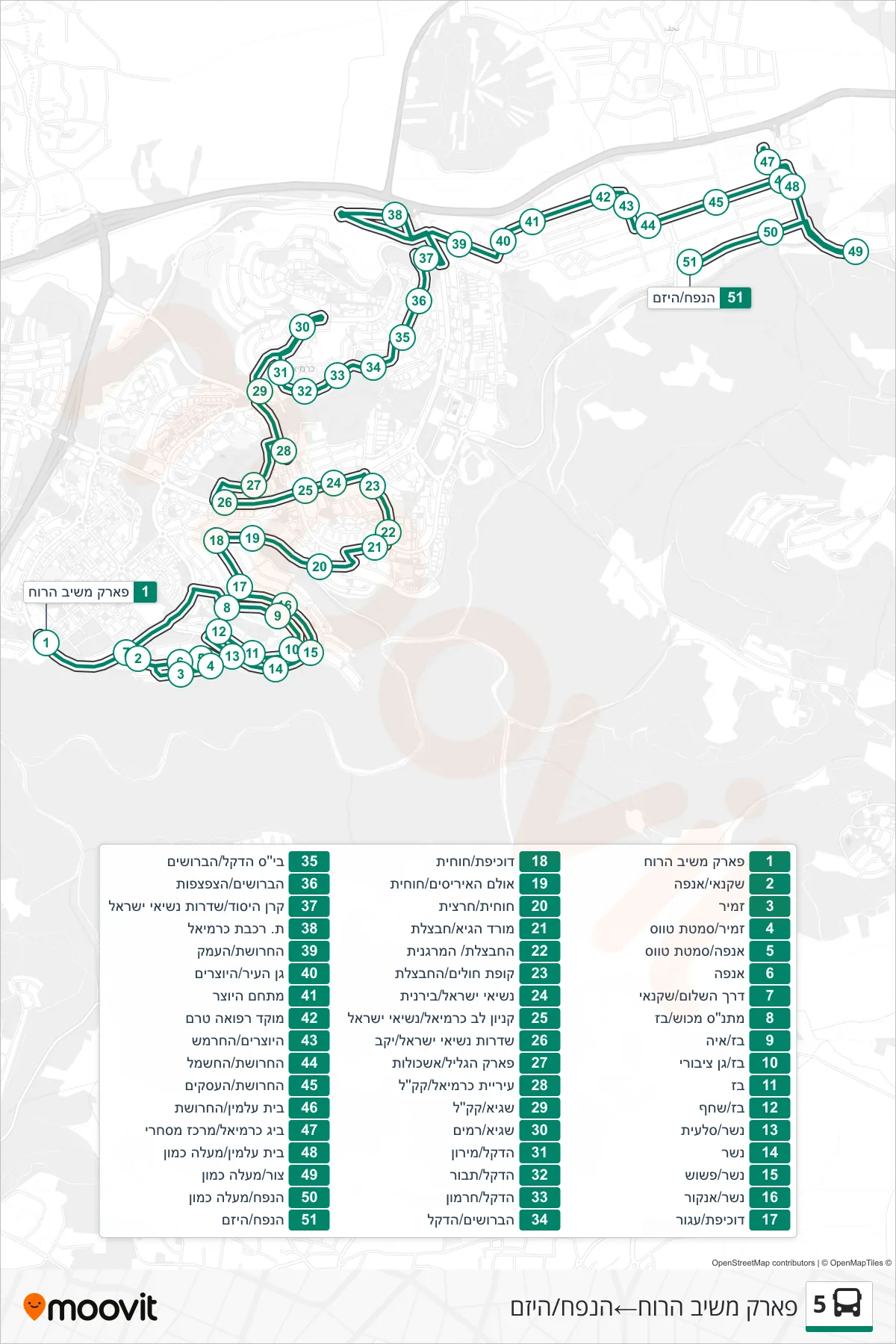
Stops list (5 - Park Meshiv HaRuach→HaNapach/HaYazam)
- Park Meshiv HaRuach
- Shachnai/Anafa
- Zamir
- Zamir/Tavas Lane
- Anafa/Tavus Lane
- Anafa
- Derech HaShalom/Shaknai
- Mekush Community Center/Paz
- Baz/Aya
- Baz/Public Garden
- Baz
- Baz/Shahaf
- Nesher/Sla'it
- Nesher
- Nesher/Pashosh
- Nesher/Ankor
- Duchifat/Agur
- Duchifat/Hochit
- Irises Hall/Hokhit
- Huhit/Hartzit
- Morad HaGai/Havatzelet
- HaHavatzelet/HaMarganit
- Health Clinic/HaHavatzelet
- Nesiei Israel/Biranit
- Carmiel Mall/Nesi'ei Israel
- Presidents of Israel Boulevard/Winery
- Park HaGalil/Eshkolot
- Karmiel Municipality/KKL
- Sagi/KKL
- Sagi/Ramim
- HaDekel/Meiron
- HaDekel/Tavor
- HaDekel/Hermon
- HaBroshim/HaDekel
- Dekel School/HaBroshim
- HaBroshim/HaTzaftzafot
- Keren HaYesod/Presidents Boulevard
- Carmiel Railway Station/Platforms
- HaCharoshet/HaEmek
- Gan HaIr/HaYotzrim
- HaYotzer Complex
- Terem Medical Center
- HaYotzrim/HaChermesh
- HaHarосhet/HaHashmal
- HaHaroshet/HaAsakim
- Cemetery/HaHarосhet
- Big Carmiel Shopping Center
- Beit Almin/Maaleh Kamon
- Tzur/Ma'ale Kamon
- HaNapach/Maaleh Kamon
- HaNapach/HaYazam