
501 Bus Route Map
View the 501 route map and see all 501 stops along the route. The map of 501 shows where the bus travels and the location of each stop, making it easy to understand the entire route at a glance.
Explore RSVG Rhein-Sieg-Verkehrsgesellschaft mbH routes on the map and see where RSVG Rhein-Sieg-Verkehrsgesellschaft mbH bus services operate. Use the 501 map to find bus stops and see how the 501 connects different areas along its trip.
All 501 stops on the map are displayed in route order, helping you follow the 501 bus from the first stop to the last.
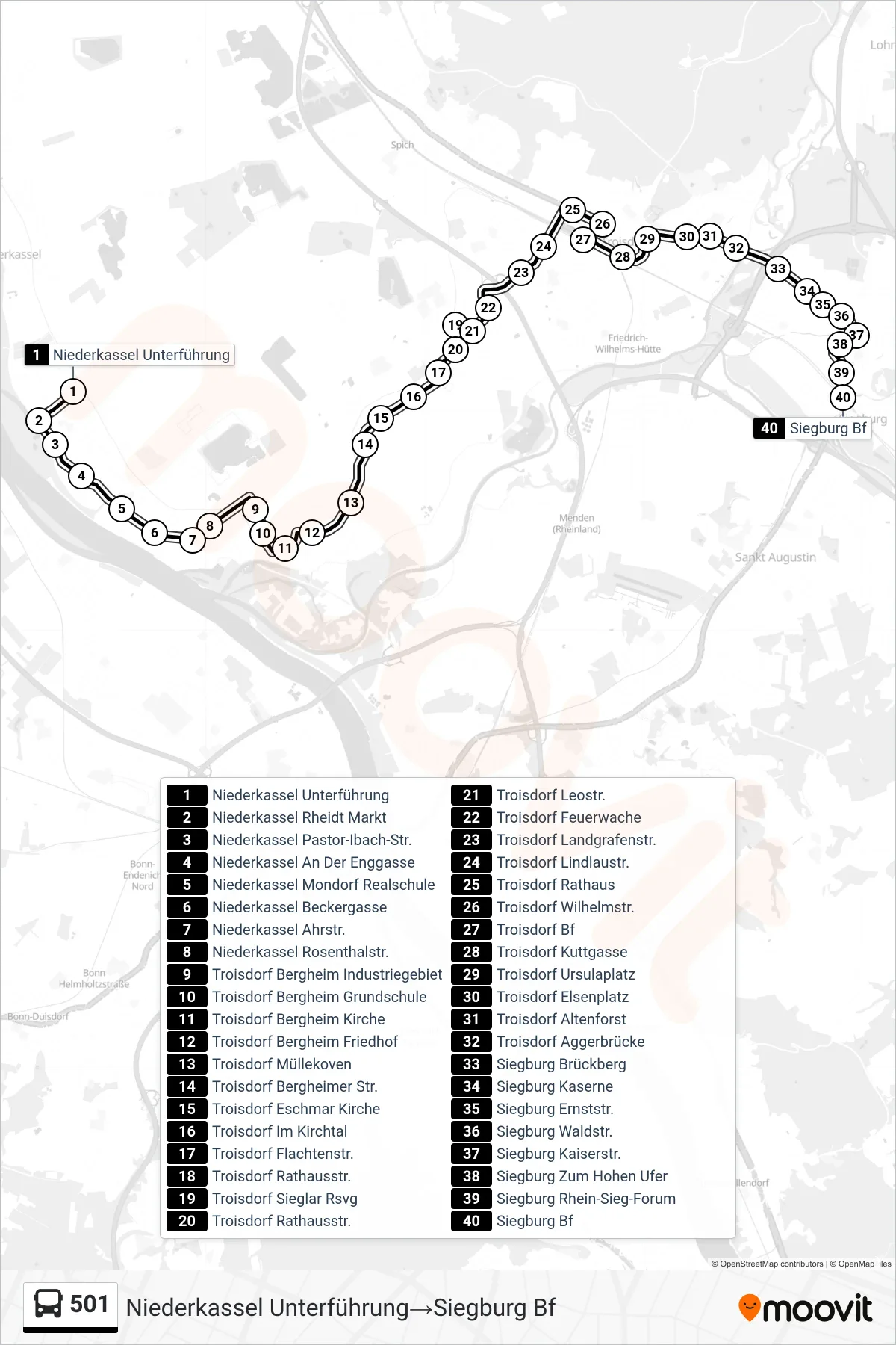
Stops list (501 - Niederkassel Unterführung→Siegburg Bf)
- Niederkassel Unterführung
- Niederkassel Rheidt Markt
- Niederkassel Pastor-Ibach-Str.
- Niederkassel An Der Enggasse
- Niederkassel Mondorf Realschule
- Niederkassel Beckergasse
- Niederkassel Ahrstr.
- Niederkassel Rosenthalstr.
- Troisdorf Bergheim Industriegebiet
- Troisdorf Bergheim Grundschule
- Troisdorf Bergheim Kirche
- Troisdorf Bergheim Friedhof
- Troisdorf Müllekoven
- Troisdorf Bergheimer Str.
- Troisdorf Eschmar Kirche
- Troisdorf Im Kirchtal
- Troisdorf Flachtenstr.
- Troisdorf Rathausstr.
- Troisdorf Sieglar Rsvg
- Troisdorf Rathausstr.
- Troisdorf Leostr.
- Troisdorf Feuerwache
- Troisdorf Landgrafenstr.
- Troisdorf Lindlaustr.
- Troisdorf Rathaus
- Troisdorf Wilhelmstr.
- Troisdorf Bf
- Troisdorf Kuttgasse
- Troisdorf Ursulaplatz
- Troisdorf Elsenplatz
- Troisdorf Altenforst
- Troisdorf Aggerbrücke
- Siegburg Brückberg
- Siegburg Kaserne
- Siegburg Ernststr.
- Siegburg Waldstr.
- Siegburg Kaiserstr.
- Siegburg Zum Hohen Ufer
- Siegburg Rhein-Sieg-Forum
- Siegburg Bf
Change direction
- Route Map - 501 - Niederkassel Lülsdorf Schulzentrum→Siegburg Bf
- Route Map - 501 - Troisdorf Sieglar Rsvg→Troisdorf Bergheim Industriegebiet
- Route Map - 501 - Siegburg Bf→Niederkassel Unterführung
- Route Map - 501 - Köln Wahn S-Bahn→Siegburg Bf
- Route Map - 501 - Siegburg Bf→Köln Wahn S-Bahn
- Route Map - 501 - Niederkassel An Der Enggasse→Siegburg Bf
- Route Map - 501 - Troisdorf Sieglar Rsvg→Köln Wahn S-Bahn
- Route Map - 501 - Troisdorf Sieglar Rsvg→Siegburg Bf
- Route Map - 501 - Troisdorf Bergheim Industriegebiet→Troisdorf Bf
- Route Map - 501 - Troisdorf Altenforst→Troisdorf Sieglar Rsvg
- Route Map - 501 - Niederkassel Unterführung→Troisdorf Bf
- Route Map - 501 - Troisdorf Sieglar Schulzentrum→Niederkassel Unterführung
- Route Map - 501 - Köln Wahn S-Bahn→Troisdorf Sieglar Rsvg
- Route Map - 501 - Niederkassel Rosenthalstr.→Köln Wahn S-Bahn
- Route Map - 501 - Troisdorf Bergeracker→Troisdorf Bergheim Industriegebiet
- Route Map - 501 - Niederkassel Lülsdorf Schulzentrum→Niederkassel Rosenthalstr.
- Route Map - 501 - Troisdorf Bergheim Industriegebiet→Troisdorf Sieglar Schulzentrum
- Route Map - 501 - Niederkassel Rosenthalstr.→Niederkassel Lülsdorf Schulzentrum