
550 Bus Route Map
View the 550 route map and see all 550 stops along the route. The map of 550 shows where the bus travels and the location of each stop, making it easy to understand the entire route at a glance.
Explore PACE routes on the map and see where PACE bus services operate. Use the 550 map to find bus stops and see how the 550 connects different areas along its trip.
All 550 stops on the map are displayed in route order, helping you follow the 550 bus from the first stop to the last.
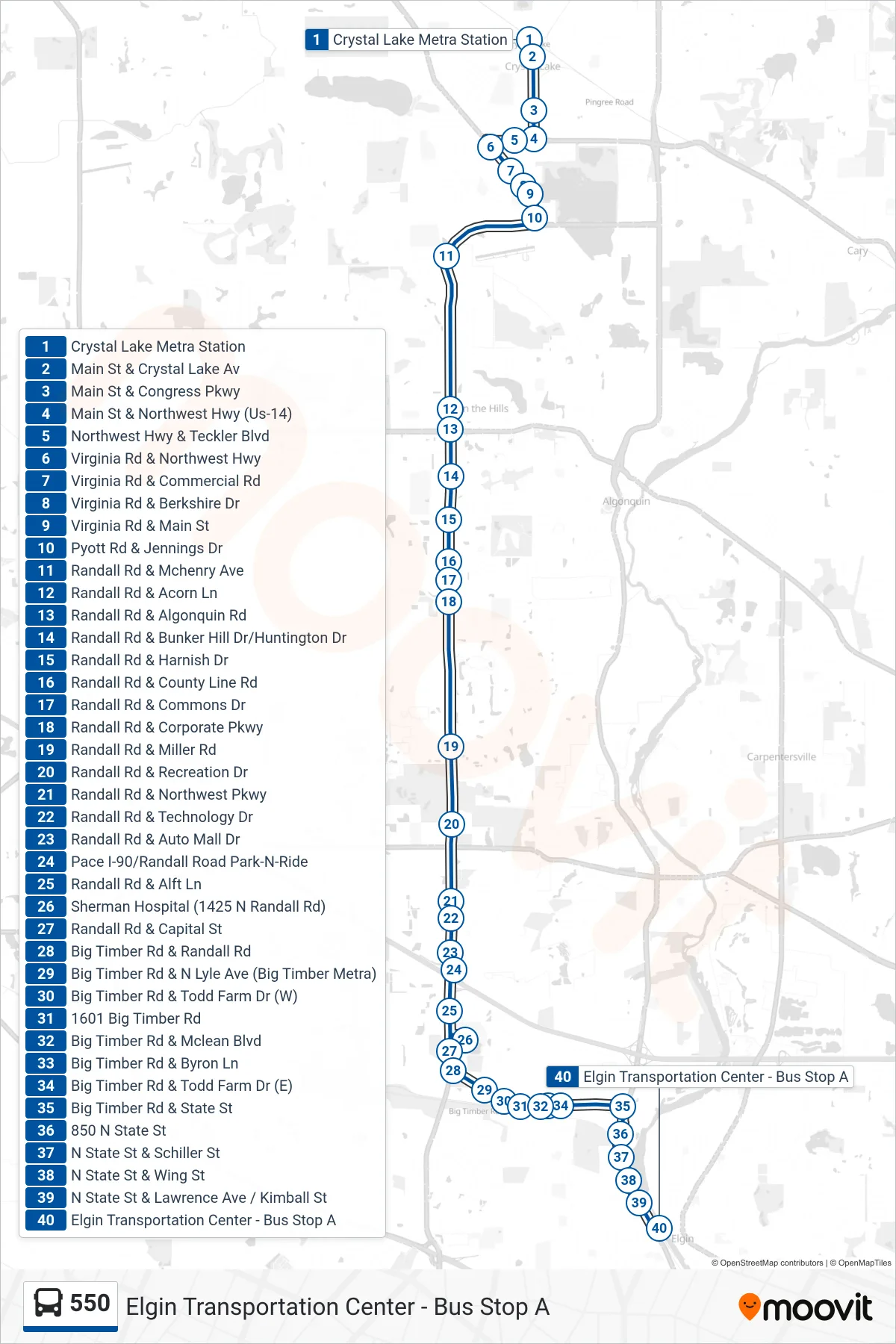
Stops list (550 - Elgin Transportation Center - Bus Stop A)
- Crystal Lake Metra Station
- Main St & Crystal Lake Av
- Main St & Congress Pkwy
- Main St & Northwest Hwy (Us-14)
- Northwest Hwy & Teckler Blvd
- Virginia Rd & Northwest Hwy
- Virginia Rd & Commercial Rd
- Virginia Rd & Berkshire Dr
- Virginia Rd & Main St
- Pyott Rd & Jennings Dr
- Randall Rd & Mchenry Ave
- Randall Rd & Acorn Ln
- Randall Rd & Algonquin Rd
- Randall Rd & Bunker Hill Dr/Huntington Dr
- Randall Rd & Harnish Dr
- Randall Rd & County Line Rd
- Randall Rd & Commons Dr
- Randall Rd & Corporate Pkwy
- Randall Rd & Miller Rd
- Randall Rd & Recreation Dr
- Randall Rd & Northwest Pkwy
- Randall Rd & Technology Dr
- Randall Rd & Auto Mall Dr
- Pace I-90/Randall Road Park-N-Ride
- Randall Rd & Alft Ln
- Sherman Hospital (1425 N Randall Rd)
- Randall Rd & Capital St
- Big Timber Rd & Randall Rd
- Big Timber Rd & N Lyle Ave (Big Timber Metra)
- Big Timber Rd & Todd Farm Dr (W)
- 1601 Big Timber Rd
- Big Timber Rd & Mclean Blvd
- Big Timber Rd & Byron Ln
- Big Timber Rd & Todd Farm Dr (E)
- Big Timber Rd & State St
- 850 N State St
- N State St & Schiller St
- N State St & Wing St
- N State St & Lawrence Ave / Kimball St
- Elgin Transportation Center - Bus Stop A