
57 Bus Route Map
View the 57 route map and see all 57 stops along the route. The map of 57 shows where the bus travels and the location of each stop, making it easy to understand the entire route at a glance.
Explore NT routes on the map and see where NT bus services operate. Use the 57 map to find bus stops and see how the 57 connects different areas along its trip.
All 57 stops on the map are displayed in route order, helping you follow the 57 bus from the first stop to the last.
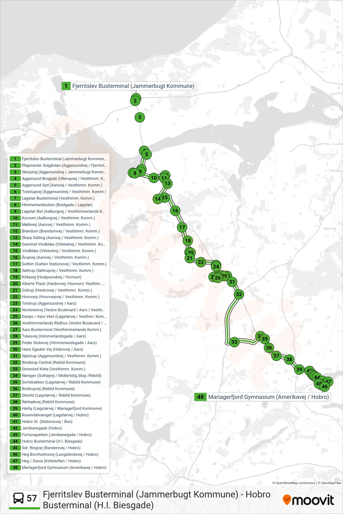
Stops list (57 - Hobro)
- Fjerritslev Busterminal (Jammerbugt Kommune)
- Plejecenter Solgården (Aggersundvej / Fjerritslev)
- Skerping (Aggersundvej / Jammerbugt Kommune)
- Aggersund Brogade (Ullerupvej / Vesthimm. Komm.)
- Aggersund Syd (Aarsvej / Vesthimm. Komm.)
- Tolstrupvej (Aggersundvej / Vesthimm. Komm.)
- Løgstør Busterminal (Vesthimm. Komm.)
- Himmerlandsstien (Bredgade / Løgstør)
- Løgstør Øst (Aalborgvej / Vesthimmerlands Komm.)
- Kornum (Aalborgvej / Vesthimm. Komm.)
- Møllevej (Aarsvej / Vesthimm. Komm.)
- Brøndum (Brøndumvej / Vesthimm. Komm.)
- Skarp Salling (Aarsvej / Vesthimm. Komm.)
- Gammel Vindblæs (Vilstedvej / Vesthimm. Komm)
- Vindblæs (Vilstedvej / Vesthimm. Komm.)
- Årupvej (Aarsvej / Vesthimm. Komm.)
- Gatten (Gatten Stationsvej / Vesthimm. Komm.)
- Søttrup (Søttrupvej / Vesthimm. Komm.)
- Kirkevej (Hvalpsundvej / Hornum)
- Alberts Plads (Havbrovej /Hornum/ Vesthim. Komm)
- Grårup (Havbrovej / Vesthimm. Komm.)
- Hvorvarp (Hvorvarpvej / Vesthimm. Komm.)
- Tolstrup (Aggersundvej / Aars)
- Nordvestvej (Vestre Boulevard / Aars / Vesthim. K)
- Danpo / Aars Vest (Løgstørvej / Vesthim. Komm)
- Vesthimmerlands Rådhus (Vestre Boulevard / Aars)
- Aars Busterminal (Vesthimmerlands Komm.)
- Tokesvej (Himmerlandsgade / Aars)
- Peder Stubsvej (Himmerlandsgade / Aars)
- Hans Egedes Vej (Hobrovej / Aars)
- Sjøstrup (Aggersundvej / Vesthimm. Komm.)
- Binderup Central (Rebild Kommune)
- Simested Kirke (Vesthimm. Komm.)
- Nørager (Solhøjvej / Midlertidig Stop /Rebild)
- Sortebakken (Løgstørvej / Rebild Kommune)
- Boldrupvej (Rebild Kommune)
- Stenild (Løgstørvej / Rebild Kommune)
- Rørbækvej (Rebild Kommune)
- Hørby (Løgstørvej / Mariagerfjord Kommune)
- Rosendalvænget (Løgstørvej / Hobro)
- Hobro St. (Stationsvej / Bus)
- Jernbanegade (Hobro)
- Fortunaparken (Jernbanegade / Hobro)
- Hobro Busterminal (H.I. Biesgade)
- Sdr. Ringvej (Randersvej / Hobro)
- Heg Bornholmsvej (Langelandsvej / Hobro)
- Heg / Dania (Kirketoften / Hobro)
- Mariagerfjord Gymnasium (Amerikavej / Hobro)
Change direction
- Route Map - 57 - Løgstør
- Route Map - 57 - Aars
- Route Map - 57 - Aars Ekstra
- Route Map - 57 - Løgstør Busterm. (Skift I Aars)
- Route Map - 57 - Aars
- Route Map - 57 - Aars Uddannelse
- Route Map - 57 - Hobro Busterm. (Skift I Aars)
- Route Map - 57 - Løgstør
- Route Map - 57 - Fjerritslev
- Route Map - 57 - Løgstør Ekspres