
6 Tram Route Map
View the 6 route map and see all 6 stops along the route. The map of 6 shows where the tram travels and the location of each stop, making it easy to understand the entire route at a glance.
Explore routes on the map and see where tram services operate. Use the 6 map to find tram stations and see how the 6 connects different areas along its trip.
All 6 stops on the map are displayed in route order, helping you follow the 6 tram from the first station to the last.
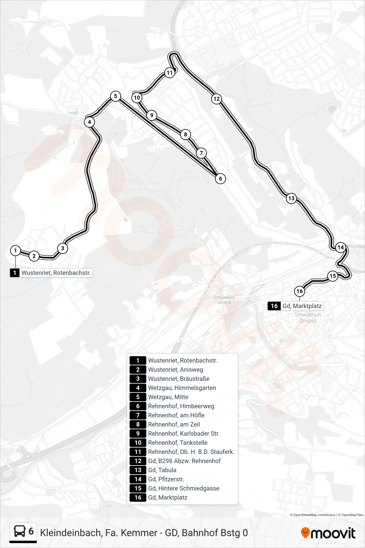
Stops list (6 - Gd, Marktplatz)
- Wustenriet, Rotenbachstr.
- Wustenriet, Anisweg
- Wustenriet, Bräustraße
- Wetzgau, Himmelsgarten
- Wetzgau, Mitte
- Rehnenhof, Himbeerweg
- Rehnenhof, am Höfle
- Rehnenhof, am Zeil
- Rehnenhof, Karlsbader Str.
- Rehnenhof, Tankstelle
- Rehnenhof, Ob. H. B.D. Stauferk.
- Gd, B298 Abzw. Rehnenhof
- Gd, Tabula
- Gd, Pfitzerstr.
- Gd, Hintere Schmiedgasse
- Gd, Marktplatz
Change direction
- Route Map - 6 - Gd, Schulzentr. Strümpfelbach
- Route Map - 6 - Kleindeinbach, Fa. Kemmer
- Route Map - 6 - Rehnenhof, Himbeerweg
- Route Map - 6 - Gd, Laichle Maiacker
- Route Map - 6 - Wustenriet, Rotenbachstr.
- Route Map - 6 - Wustenriet, Birkenäckerstr.
- Route Map - 6 - Wustenriet, Bräustraße
- Route Map - 6 - Hangendeinbach, Kreisstraße
- Route Map - 6 - Kleindeinbach, Ortsmitte
- Route Map - 6 - Hangendeinbach, Zum Remstal
- Route Map - 6 - Gd, Bahnhof
- Route Map - 6 - Gd, Bahnhof
- Route Map - 6 - Großdeinbach, Ev. Kirche
- Route Map - 6 - Rehnenhof, An Der Ob. Halde 62