
60 Bus Route Map
View the 60 route map and see all 60 stops along the route. The map of 60 shows where the bus travels and the location of each stop, making it easy to understand the entire route at a glance.
Explore MetroLINK routes on the map and see where MetroLINK bus services operate. Use the 60 map to find bus stops and see how the 60 connects different areas along its trip.
All 60 stops on the map are displayed in route order, helping you follow the 60 bus from the first stop to the last.
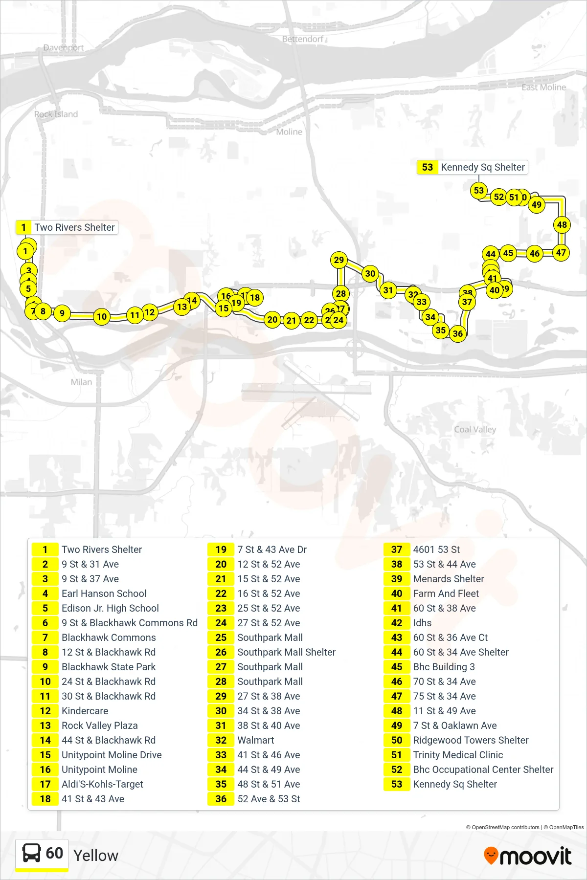
Stops list (60 - 60 East, Yellow, Kennedy Sq)
- Two Rivers Shelter
- 9 St & 31 Ave
- 9 St & 37 Ave
- Earl Hanson School
- Edison Jr. High School
- 9 St & Blackhawk Commons Rd
- Blackhawk Commons
- 12 St & Blackhawk Rd
- Blackhawk State Park
- 24 St & Blackhawk Rd
- 30 St & Blackhawk Rd
- Kindercare
- Rock Valley Plaza
- 44 St & Blackhawk Rd
- Unitypoint Moline Drive
- Unitypoint Moline
- Aldi'S-Kohls-Target
- 41 St & 43 Ave
- 7 St & 43 Ave Dr
- 12 St & 52 Ave
- 15 St & 52 Ave
- 16 St & 52 Ave
- 25 St & 52 Ave
- 27 St & 52 Ave
- Southpark Mall
- Southpark Mall Shelter
- Southpark Mall
- Southpark Mall
- 27 St & 38 Ave
- 34 St & 38 Ave
- 38 St & 40 Ave
- Walmart
- 41 St & 46 Ave
- 44 St & 49 Ave
- 48 St & 51 Ave
- 52 Ave & 53 St
- 4601 53 St
- 53 St & 44 Ave
- Menards Shelter
- Farm And Fleet
- 60 St & 38 Ave
- Idhs
- 60 St & 36 Ave Ct
- 60 St & 34 Ave Shelter
- Bhc Building 3
- 70 St & 34 Ave
- 75 St & 34 Ave
- 11 St & 49 Ave
- 7 St & Oaklawn Ave
- Ridgewood Towers Shelter
- Trinity Medical Clinic
- Bhc Occupational Center Shelter
- Kennedy Sq Shelter
Change direction
- Route Map - 60 - 60 East, Yellow, Black Hawk College
- Route Map - 60 - 60 East, Yellow, Two Rivers
- Route Map - 60 - 60 East, Yellow, Butterworth, Black Hawk College
- Route Map - 60 - 60lb, Yellow, Last Bus ->, Two Rivers
- Route Map - 60 - 60 West, Yellow, District Station, Rock Island
- Route Map - 60 - 60lb, Yellow, Last Bus ->, District Station
- Route Map - 60 - 60lt, Yellow, Last Trip ->, Black Hawk College
- Route Map - 60 - 60 West, Yellow, Two Rivers
- Route Map - 60 - 60lb, Yellow, Last Bus ->, Kennedy Sq
- Route Map - 60 - 60lb, Yellow, Last Bus ->, Two Rivers
- Route Map - 60 - 60lb, Yellow, Last Bus ->, Southpark
- Route Map - 60 - 60lb, Yellow, Last Bus ->, Rock Valley