
65 - 66 Bus Route Map
View the 65 - 66 route map and see all 65 - 66 stops along the route. The map of 65 - 66 shows where the bus travels and the location of each stop, making it easy to understand the entire route at a glance.
Explore Autobuses routes on the map and see where Autobuses bus services operate. Use the 65 - 66 map to find bus stops and see how the 65 - 66 connects different areas along its trip.
All 65 - 66 stops on the map are displayed in route order, helping you follow the 65 - 66 bus from the first stop to the last.
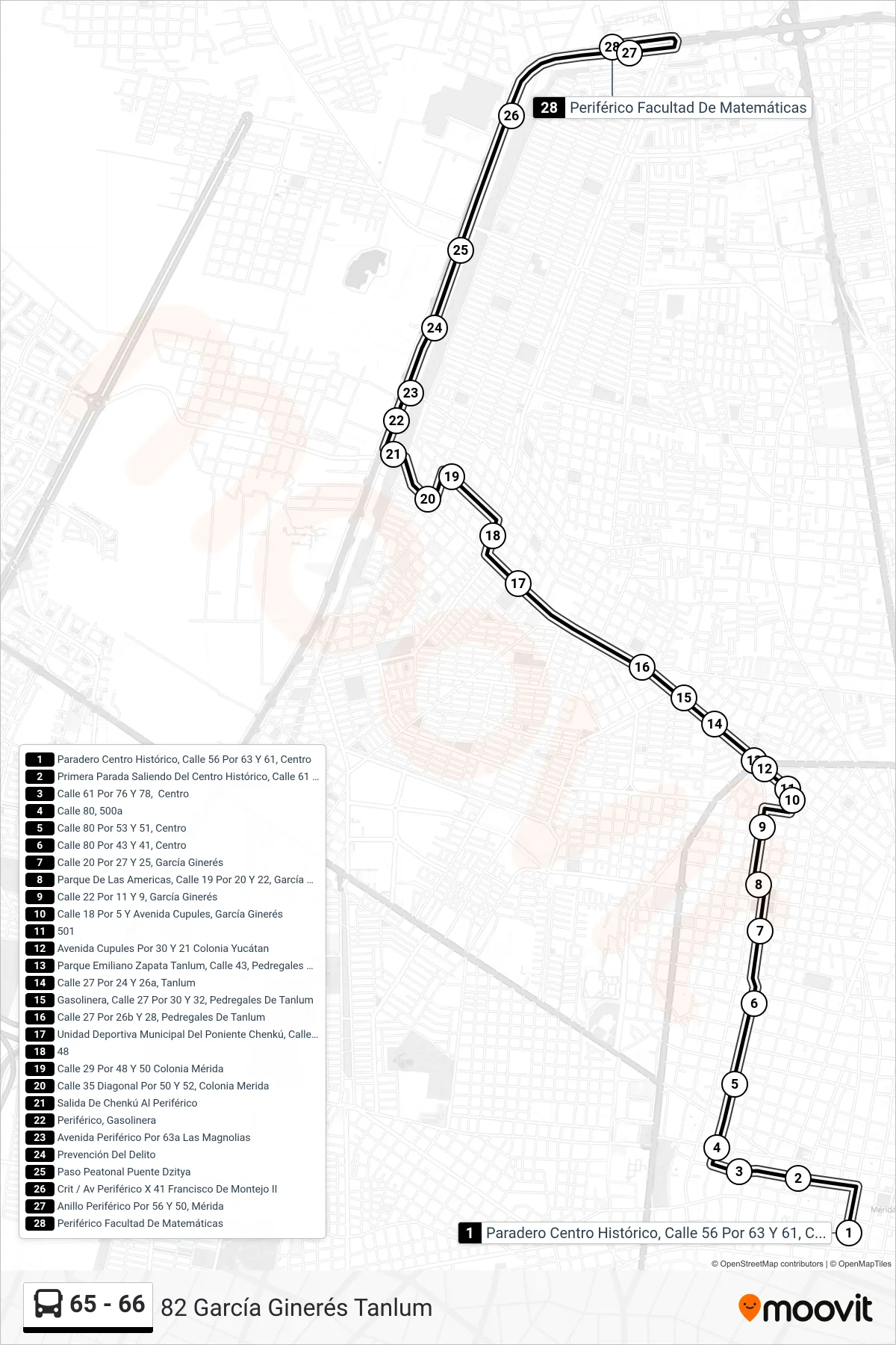
Stops list (65 - 66 - 82 García Ginerés Tanlum)
- Paradero Centro Histórico, Calle 56 Por 63 Y 61, Centro
- Primera Parada Saliendo Del Centro Histórico, Calle 61 Por 70 Y 72, Centro
- Calle 61 Por 76 Y 78, Centro
- Calle 80, 500a
- Calle 80 Por 53 Y 51, Centro
- Calle 80 Por 43 Y 41, Centro
- Calle 20 Por 27 Y 25, García Ginerés
- Parque De Las Americas, Calle 19 Por 20 Y 22, García Ginerés
- Calle 22 Por 11 Y 9, García Ginerés
- Calle 18 Por 5 Y Avenida Cupules, García Ginerés
- 501
- Avenida Cupules Por 30 Y 21 Colonia Yucátan
- Parque Emiliano Zapata Tanlum, Calle 43, Pedregales De Tanlum
- Calle 27 Por 24 Y 26a, Tanlum
- Gasolinera, Calle 27 Por 30 Y 32, Pedregales De Tanlum
- Calle 27 Por 26b Y 28, Pedregales De Tanlum
- Unidad Deportiva Municipal Del Poniente Chenkú, Calle 19 Por 34 Y 36 San Luis Chuburná
- 48
- Calle 29 Por 48 Y 50 Colonia Mérida
- Calle 35 Diagonal Por 50 Y 52, Colonia Merida
- Salida De Chenkú Al Periférico
- Periférico, Gasolinera
- Avenida Periférico Por 63a Las Magnolias
- Prevención Del Delito
- Paso Peatonal Puente Dzitya
- Crit / Av Periférico X 41 Francisco De Montejo II
- Anillo Periférico Por 56 Y 50, Mérida
- Periférico Facultad De Matemáticas