
680 Bus Route Map
View the 680 route map and see all 680 stops along the route. The map of 680 shows where the bus travels and the location of each stop, making it easy to understand the entire route at a glance.
Explore NVBW routes on the map and see where NVBW bus services operate. Use the 680 map to find bus stops and see how the 680 connects different areas along its trip.
All 680 stops on the map are displayed in route order, helping you follow the 680 bus from the first stop to the last.
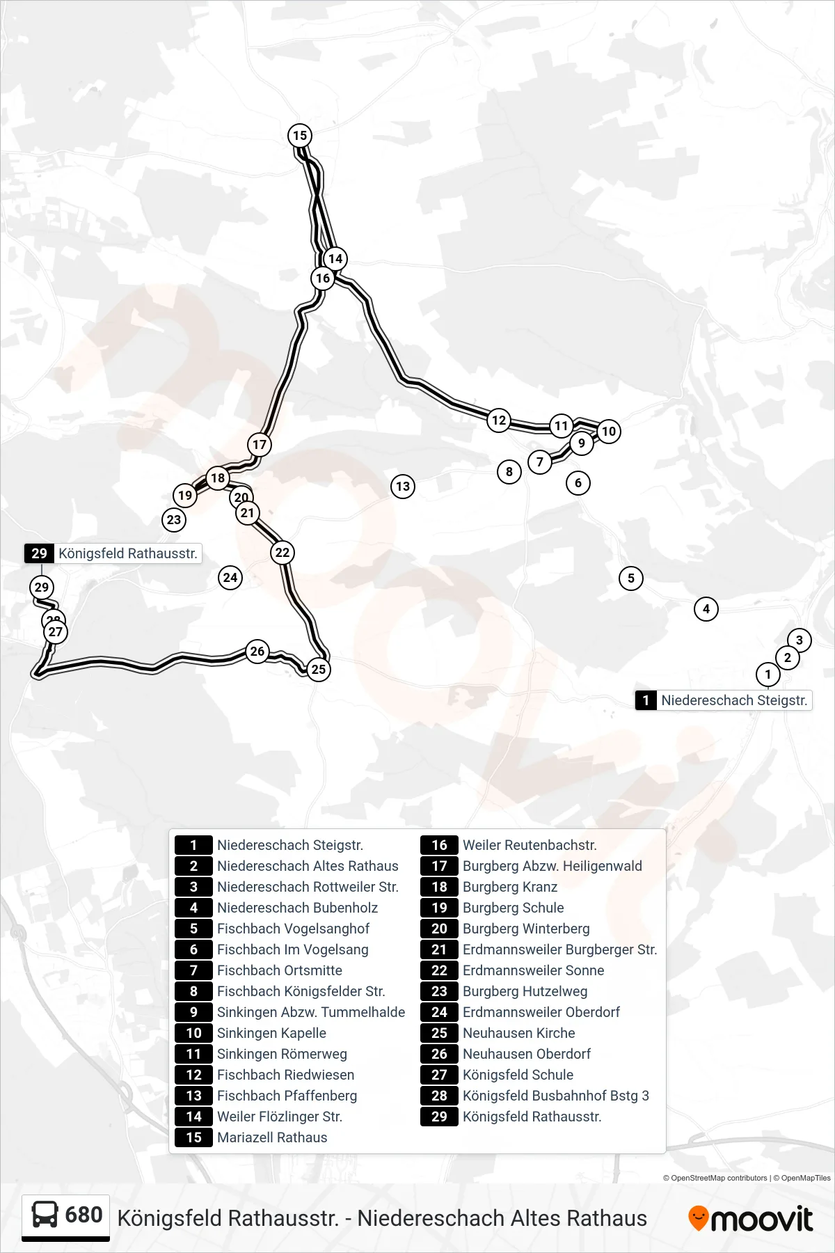
Stops list (680 - Königsfeld Rathausstr.)
- Niedereschach Steigstr.
- Niedereschach Altes Rathaus
- Niedereschach Rottweiler Str.
- Niedereschach Bubenholz
- Fischbach Vogelsanghof
- Fischbach Im Vogelsang
- Fischbach Ortsmitte
- Fischbach Königsfelder Str.
- Sinkingen Abzw. Tummelhalde
- Sinkingen Kapelle
- Sinkingen Römerweg
- Fischbach Riedwiesen
- Fischbach Pfaffenberg
- Weiler Flözlinger Str.
- Mariazell Rathaus
- Weiler Reutenbachstr.
- Burgberg Abzw. Heiligenwald
- Burgberg Kranz
- Burgberg Schule
- Burgberg Winterberg
- Erdmannsweiler Burgberger Str.
- Erdmannsweiler Sonne
- Burgberg Hutzelweg
- Erdmannsweiler Oberdorf
- Neuhausen Kirche
- Neuhausen Oberdorf
- Königsfeld Schule
- Königsfeld Busbahnhof Bstg 3
- Königsfeld Rathausstr.
Change direction
- Route Map - 680 - Königsfeld Busbahnhof
- Route Map - 680 - Fischbach Ortsmitte
- Route Map - 680 - Erdmannsweiler Oberdorf
- Route Map - 680 - Niedereschach Öschlestr
- Route Map - 680 - Neuhausen Kirche
- Route Map - 680 - Fischbach Ortsmitte
- Route Map - 680 - Mönchweiler am Weiherdamm
- Route Map - 680 - Niedereschach Altes Rathaus
- Route Map - 680 - Mariazell Rathaus
- Route Map - 680 - Weiler Reutenbachstr.