
7 Bus Route Map
View the 7 route map and see all 7 stops along the route. The map of 7 shows where the bus travels and the location of each stop, making it easy to understand the entire route at a glance.
Explore ATM Messina routes on the map and see where ATM Messina bus services operate. Use the 7 map to find bus stops and see how the 7 connects different areas along its trip.
All 7 stops on the map are displayed in route order, helping you follow the 7 bus from the first stop to the last.
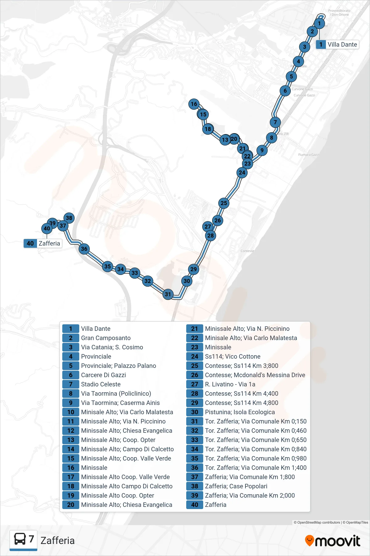
Stops list (7 - Zafferia)
- Dante Villa
- Great Cemetery
- Catania Street; St. Cosimo
- Provincial
- Provincial - Palano Palace
- Gazzi Prison
- Celeste Stadium
- Via Taormina (Hospital)
- Via Taormina; Ainis Barracks
- Upper Minisale, Via Carlo Malatesta
- Upper Minissale; N. Piccinino Street
- Upper Minissale, Evangelical Church
- Upper Minissale, Opter Cooperative
- Upper Minissale Soccer Field
- Upper Minissale; Valle Verde Cooperative
- Minissale
- Upper Minissale Valle Verde Cooperative
- Upper Minissale Soccer Field
- Upper Minissale Opter Cooperative
- Upper Minissale, Evangelical Church
- Upper Minissale; N. Piccinino Street
- Upper Minisale, Via Carlo Malatesta
- Minissale
- State Road 114; Vico Cottone
- Contesse - State Road 114 Km 3.800
- Contesse; McDonald's Messina Drive
- R. Livatino - Street 1a
- Contesse, State Road 114 Km 4.400
- Contesse, SS114 Km 4.800
- Pistunina Recycling Center
- Tor. Zafferia; Via Comunale Km 0;150
- Zafferia Stream; Municipal Road Km 0;460
- Zafferia Stream, Municipal Road Km 0.650
- Tor. Zafferia, Municipal Road Km 0.840
- Tor. Zafferia; Municipal Road Km 0.980
- Zafferia Stream, Municipal Road Km 1.400
- Zafferia; Municipal Road Km 1.800
- Zafferia; Public Housing
- Zafferia; Municipal Road Km 2.000
- Zafferia