
7 Light Rail Route Map
View the 7 route map and see all 7 stops along the route. The map of 7 shows where the light rail travels and the location of each stop, making it easy to understand the entire route at a glance.
Explore KVB Kölner Verkehrs-Betriebe AG routes on the map and see where KVB Kölner Verkehrs-Betriebe AG light rail services operate. Use the 7 map to find light rail stations and see how the 7 connects different areas along its trip.
All 7 stops on the map are displayed in route order, helping you follow the 7 light rail from the first station to the last.
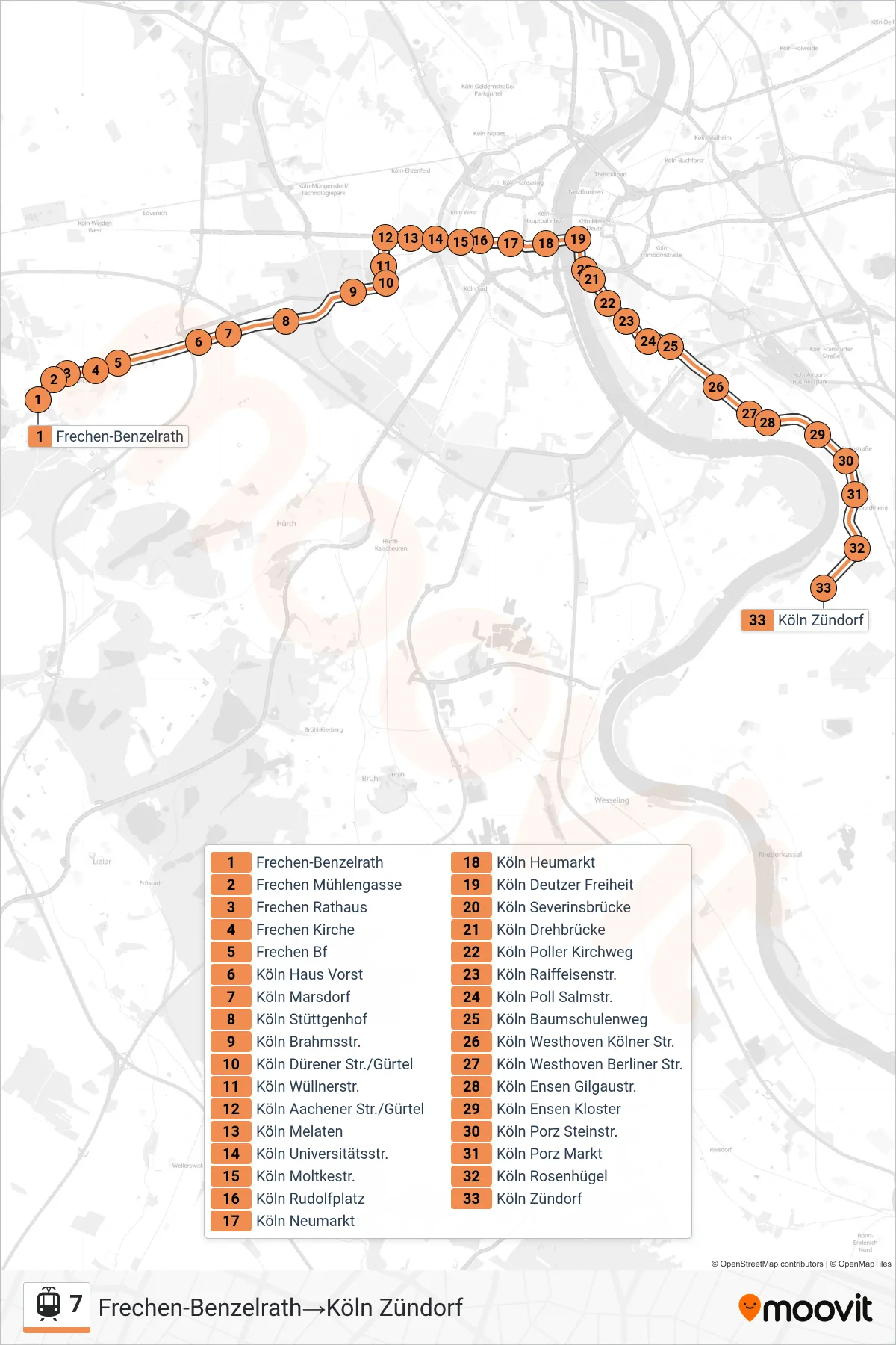
Stops list (7 - Frechen-Benzelrath→Köln Zündorf)
- Frechen-Benzelrath
- Frechen Mühlengasse
- Frechen Rathaus
- Frechen Kirche
- Frechen Bf
- Köln Haus Vorst
- Köln Marsdorf
- Köln Stüttgenhof
- Köln Brahmsstr.
- Köln Dürener Str./Gürtel
- Köln Wüllnerstr.
- Köln Aachener Str./Gürtel
- Köln Melaten
- Köln Universitätsstr.
- Köln Moltkestr.
- Köln Rudolfplatz
- Köln Neumarkt
- Köln Heumarkt
- Köln Deutzer Freiheit
- Köln Severinsbrücke
- Köln Drehbrücke
- Köln Poller Kirchweg
- Köln Raiffeisenstr.
- Köln Poll Salmstr.
- Köln Baumschulenweg
- Köln Westhoven Kölner Str.
- Köln Westhoven Berliner Str.
- Köln Ensen Gilgaustr.
- Köln Ensen Kloster
- Köln Porz Steinstr.
- Köln Porz Markt
- Köln Rosenhügel
- Köln Zündorf
Change direction
- Route Map - 7 - Frechen Bf→Frechen-Benzelrath
- Route Map - 7 - Köln Zündorf→Köln Aachener Str./Gürtel
- Route Map - 7 - Köln Zündorf→Frechen Bf
- Route Map - 7 - Köln Zündorf→Frechen-Benzelrath
- Route Map - 7 - Köln Rudolfplatz→Köln Aachener Str./Gürtel
- Route Map - 7 - Köln Deutzer Freiheit→Köln Zündorf
- Route Map - 7 - Köln Rudolfplatz→Frechen Bf
- Route Map - 7 - Köln Zündorf→Köln Moltkestr.
- Route Map - 7 - Köln Zündorf→Köln Deutzer Freiheit
- Route Map - 7 - Frechen-Benzelrath→Köln Aachener Str./Gürtel
- Route Map - 7 - Frechen Bf→Köln Rudolfplatz
- Route Map - 7 - Frechen-Benzelrath→Köln Rudolfplatz
- Route Map - 7 - Frechen-Benzelrath→Frechen Bf
- Route Map - 7 - Frechen-Benzelrath→Köln Neumarkt
- Route Map - 7 - Frechen Bf→Köln Aachener Str./Gürtel
- Route Map - 7 - Köln Aachener Str./Gürtel→Köln Porz Markt
- Route Map - 7 - Köln Moltkestr.→Köln Zündorf
- Route Map - 7 - Köln Aachener Str./Gürtel→Köln Zündorf
- Route Map - 7 - Frechen Bf→Köln Zündorf
- Route Map - 7 - Köln Neumarkt→Frechen-Benzelrath
- Route Map - 7 - Köln Aachener Str./Gürtel→Frechen-Benzelrath
- Route Map - 7 - Frechen-Benzelrath→Köln Alter Militärring
- Route Map - 7 - Köln Rudolfplatz→Frechen-Benzelrath
- Route Map - 7 - Köln Alter Militärring→Frechen-Benzelrath
- Route Map - 7 - Köln Aachener Str./Gürtel→Köln Rudolfplatz