
71 Bus Route Map
View the 71 route map and see all 71 stops along the route. The map of 71 shows where the bus travels and the location of each stop, making it easy to understand the entire route at a glance.
Explore RÖHLER Touristik GmbH routes on the map and see where RÖHLER Touristik GmbH bus services operate. Use the 71 map to find bus stops and see how the 71 connects different areas along its trip.
All 71 stops on the map are displayed in route order, helping you follow the 71 bus from the first stop to the last.
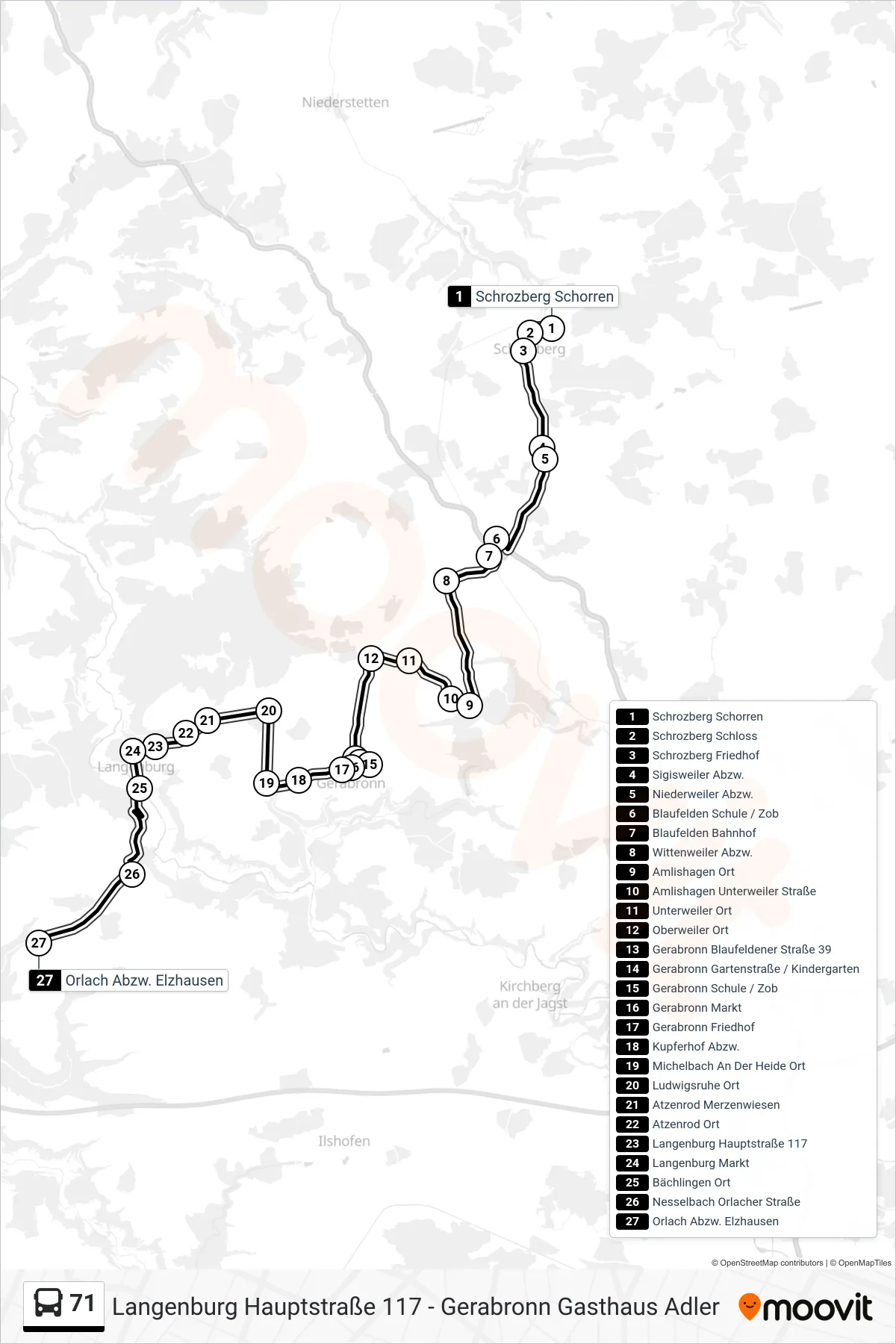
Stops list (71 - Orlach Abzw. Elzhausen)
- Schrozberg Schorren
- Schrozberg Schloss
- Schrozberg Friedhof
- Sigisweiler Abzw.
- Niederweiler Abzw.
- Blaufelden Schule / Zob
- Blaufelden Bahnhof
- Wittenweiler Abzw.
- Amlishagen Ort
- Amlishagen Unterweiler Straße
- Unterweiler Ort
- Oberweiler Ort
- Gerabronn Blaufeldener Straße 39
- Gerabronn Gartenstraße / Kindergarten
- Gerabronn Schule / Zob
- Gerabronn Markt
- Gerabronn Friedhof
- Kupferhof Abzw.
- Michelbach An Der Heide Ort
- Ludwigsruhe Ort
- Atzenrod Merzenwiesen
- Atzenrod Ort
- Langenburg Hauptstraße 117
- Langenburg Markt
- Bächlingen Ort
- Nesselbach Orlacher Straße
- Orlach Abzw. Elzhausen
Change direction
- Route Map - 71 - Obersteinach Ort
- Route Map - 71 - Gerabronn Schule / Zob
- Route Map - 71 - Schwäbisch Hall Zob
- Route Map - 71 - Dünsbach Obersteinacher Straße
- Route Map - 71 - Unterregenbach Ort
- Route Map - 71 - Langenburg Hauptstraße 117
- Route Map - 71 - Schrozberg Zob
- Route Map - 71 - Braunsbach Rabbinat
- Route Map - 71 - Bächlingen Ort
- Route Map - 71 - Nesselbach Steinacher Straße
- Route Map - 71 - Obersteinach Ort
- Route Map - 71 - Schwäbisch Hall Waldorfschule
- Route Map - 71 - Gerabronn Gasthaus Adler
- Route Map - 71 - Langenburg Neue Schule
- Route Map - 71 - Gerabronn Bahnhof
- Route Map - 71 - Gerabronn Schule / Zob
- Route Map - 71 - Jungholzhausen Ort
- Route Map - 71 - Langenburg Kriegerdenkmal
- Route Map - 71 - Amlishagen Ort
- Route Map - 71 - Langenburg Markt
- Route Map - 71 - Langenburg Neue Schule
- Route Map - 71 - Schwäbisch Hall Schenkensee
- Route Map - 71 - Blaufelden Bahnhof
- Route Map - 71 - Blaufelden Schule / Zob
- Route Map - 71 - Schrozberg Schorren