
71C Bus Route Map
View the 71C route map and see all 71C stops along the route. The map of 71C shows where the bus travels and the location of each stop, making it easy to understand the entire route at a glance.
Explore Pittsburgh Regional Transit routes on the map and see where Pittsburgh Regional Transit bus services operate. Use the 71C map to find bus stops and see how the 71C connects different areas along its trip.
All 71C stops on the map are displayed in route order, helping you follow the 71C bus from the first stop to the last.
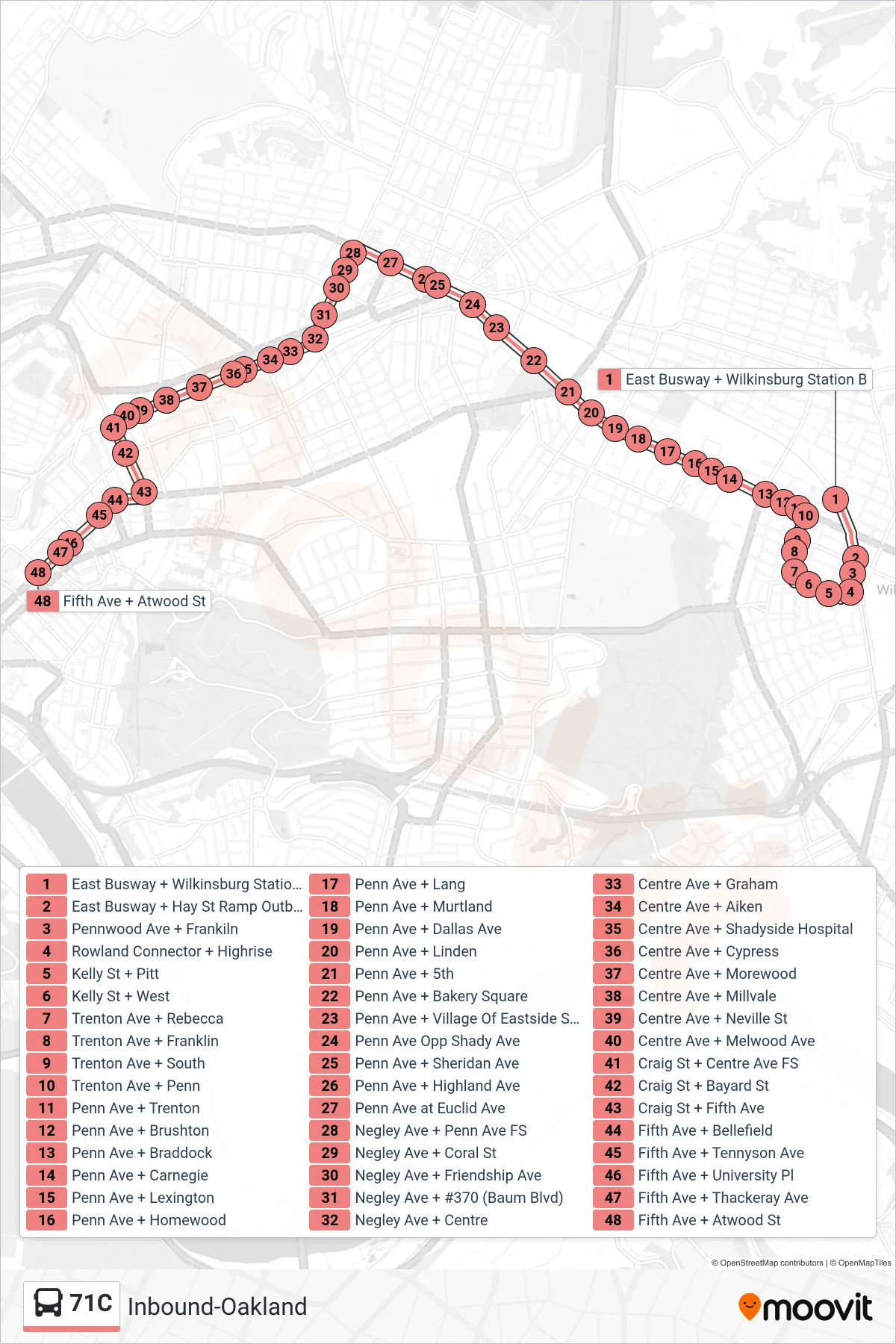
Stops list (71C - Inbound-Oakland)
- East Busway + Wilkinsburg Station B
- East Busway + Hay St Ramp Outbound Shelter
- Pennwood Ave + Frankiln
- Rowland Connector + Highrise
- Kelly St + Pitt
- Kelly St + West
- Trenton Ave + Rebecca
- Trenton Ave + Franklin
- Trenton Ave + South
- Trenton Ave + Penn
- Penn Ave + Trenton
- Penn Ave + Brushton
- Penn Ave + Braddock
- Penn Ave + Carnegie
- Penn Ave + Lexington
- Penn Ave + Homewood
- Penn Ave + Lang
- Penn Ave + Murtland
- Penn Ave + Dallas Ave
- Penn Ave + Linden
- Penn Ave + 5th
- Penn Ave + Bakery Square
- Penn Ave + Village Of Eastside Shopping Center
- Penn Ave Opp Shady Ave
- Penn Ave + Sheridan Ave
- Penn Ave + Highland Ave
- Penn Ave at Euclid Ave
- Negley Ave + Penn Ave FS
- Negley Ave + Coral St
- Negley Ave + Friendship Ave
- Negley Ave + #370 (Baum Blvd)
- Negley Ave + Centre
- Centre Ave + Graham
- Centre Ave + Aiken
- Centre Ave + Shadyside Hospital
- Centre Ave + Cypress
- Centre Ave + Morewood
- Centre Ave + Millvale
- Centre Ave + Neville St
- Centre Ave + Melwood Ave
- Craig St + Centre Ave FS
- Craig St + Bayard St
- Craig St + Fifth Ave
- Fifth Ave + Bellefield
- Fifth Ave + Tennyson Ave
- Fifth Ave + University Pl
- Fifth Ave + Thackeray Ave
- Fifth Ave + Atwood St