
72A Bus Route Map
View the 72A route map and see all 72A stops along the route. The map of 72A shows where the bus travels and the location of each stop, making it easy to understand the entire route at a glance.
Explore Egged routes on the map and see where Egged bus services operate. Use the 72A map to find bus stops and see how the 72A connects different areas along its trip.
All 72A stops on the map are displayed in route order, helping you follow the 72A bus from the first stop to the last.
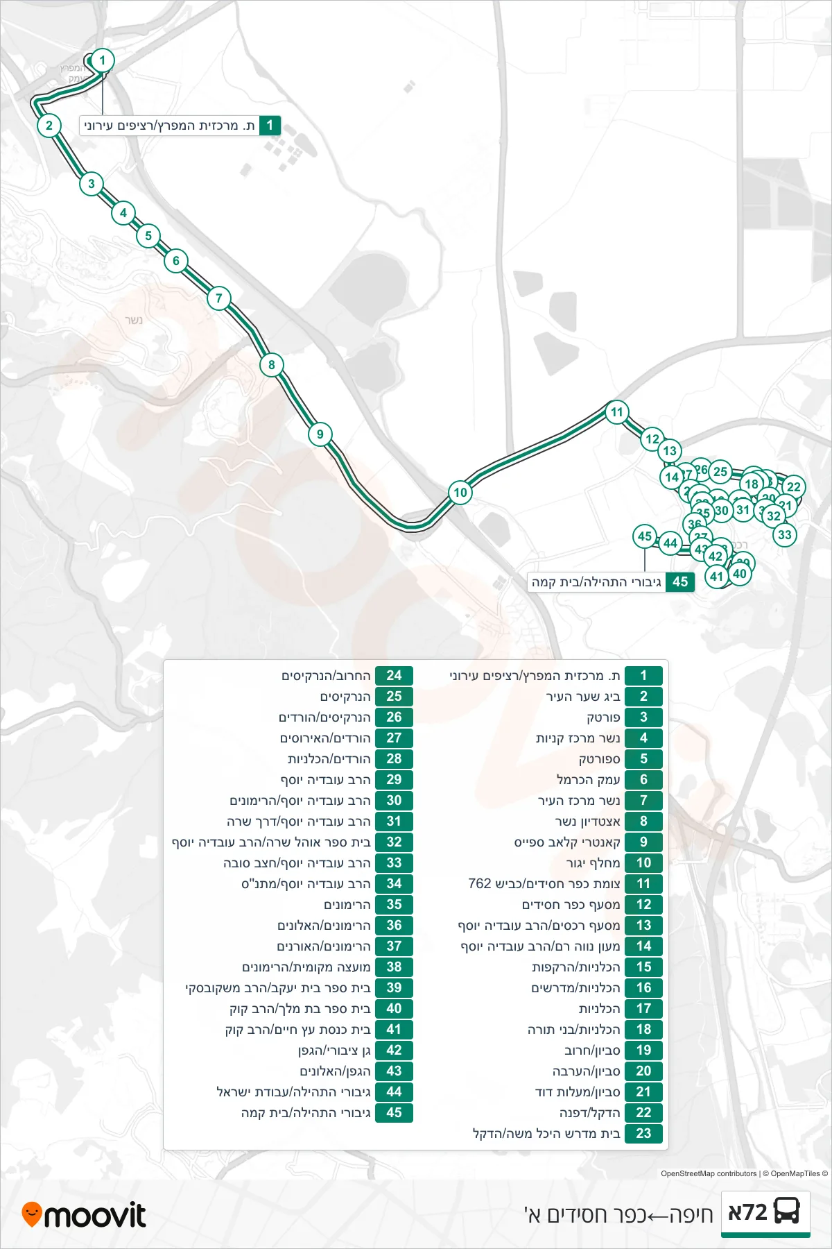
Stops list (72A - Haifa→Kfar Hasidim Alef)
- HaMifratz Central Station/City Platforms
- Big Sha'ar Ha'ir
- Portek
- Nesher Shopping Center
- Sportek
- Carmel Valley
- Nesher City Center
- Nesher Stadium
- Country Club Space
- Yagur Interchange
- Kfar Hasidim Junction/Road 762
- Kfar Hasidim Junction
- Rechasim Junction/Rav Ovadia Yosef
- Neve Ram Center/Rabbi Ovadia Yosef
- HaKalaniot/HaRakafoot
- HaKalaniot/Midrashim
- HaKalaniyot
- HaKalaniyot/Bnei Torah
- Savyon/Haruv
- Savyon/HaArava
- Savyon/Maalot David
- HaDekel/Dafna
- Heichal Moshe Study Hall/HaDekel
- HaHaruv/HaNarkisim
- HaNarkisim
- HaNarkisim/HaVradim
- HaVradim/HaIrisim
- HaVradim/HaKalaniyot
- Rabbi Ovadia Yosef
- Rabbi Ovadia Yosef/HaRimonim
- Rabbi Ovadia Yosef/Derech Sara
- Ohel Sarah School/Rabbi Ovadia Yosef
- Rabbi Ovadia Yosef/Hatzav Loop
- Rav Ovadia Yosef/Community Center
- HaRimonim
- HaRimonim/HaAlonim
- HaRimonim/HaOranim
- Local Council/HaRimonim
- Beit Yaakov School/Rav Mashkovsky
- Beit Melech School/HaRav Kook
- Etz Chaim Synagogue/HaRav Kook
- Public Garden/HaGefen
- HaGefen/HaAlonim
- Giborei HaTehila/Avodat Israel
- Giborei HaTehila/Beit Kama