
7E Bus Route Map
View the 7E route map and see all 7E stops along the route. The map of 7E shows where the bus travels and the location of each stop, making it easy to understand the entire route at a glance.
Explore Bus Átha Cliath – Dublin Bus routes on the map and see where Bus Átha Cliath – Dublin Bus bus services operate. Use the 7E map to find bus stops and see how the 7E connects different areas along its trip.
All 7E stops on the map are displayed in route order, helping you follow the 7E bus from the first stop to the last.
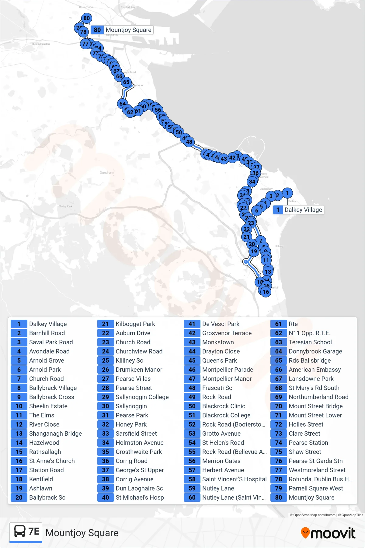
Stops list (7E - Mountjoy Square)
- Dalkey Village
- Barnhill Road
- Saval Park Road
- Avondale Road
- Arnold Grove
- Arnold Park
- Church Road
- Ballybrack Village
- Ballybrack Cross
- Sheelin Estate
- The Elms
- River Close
- Shanganagh Bridge
- Hazelwood
- Rathsallagh
- St Anne's Church
- Station Road
- Kentfield
- Ashlawn
- Ballybrack Sc
- Kilbogget Park
- Auburn Drive
- Church Road
- Churchview Road
- Killiney Sc
- Drumkeen Manor
- Pearse Villas
- Pearse Street
- Sallynoggin College
- Sallynoggin
- Pearse Park
- Honey Park
- Sarsfield Street
- Holmston Avenue
- Crosthwaite Park
- Corrig Road
- George's St Upper
- Corrig Avenue
- Dun Laoghaire Sc
- St Michael's Hosp
- De Vesci Park
- Grosvenor Terrace
- Monkstown
- Drayton Close
- Queen's Park
- Montpellier Parade
- Montpellier Manor
- Frascati Sc
- Rock Road
- Blackrock Clinic
- Blackrock College
- Rock Road (Booterstown Avenue)
- Grotto Avenue
- St Helen's Road
- Rock Road (Bellevue Avenue)
- Merrion Gates
- Herbert Avenue
- Saint Vincent'S Hospital
- Nutley Lane
- Nutley Lane (Saint Vincent'S Hospital)
- Rte
- N11 Opp. R.T.E.
- Teresian School
- Donnybrook Garage
- Rds Ballsbridge
- American Embassy
- Lansdowne Park
- St Mary's Rd South
- Northumberland Road
- Mount Street Bridge
- Mount Street Lower
- Holles Street
- Clare Street
- Pearse Station
- Shaw Street
- Pearse St Garda Stn
- Westmoreland Street
- Rotunda, Dublin Bus Head Office
- Parnell Square West
- Mountjoy Square