
8 Bus Route Map
View the 8 route map and see all 8 stops along the route. The map of 8 shows where the bus travels and the location of each stop, making it easy to understand the entire route at a glance.
Explore KYMA MOBILITY routes on the map and see where KYMA MOBILITY bus services operate. Use the 8 map to find bus stops and see how the 8 connects different areas along its trip.
All 8 stops on the map are displayed in route order, helping you follow the 8 bus from the first stop to the last.
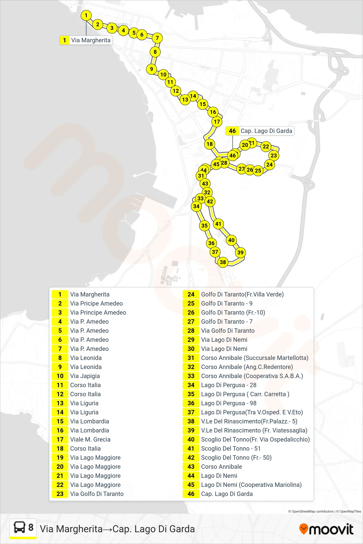
Stops list (8 - Margherita Street→Lake Garda Terminal)
- Margherita Street
- Prince Amedeo Street
- Principe Amedeo Street
- P. Amedeo Street
- P. Amedeo Street
- P. Amedeo Street
- P. Amedeo Street
- Leonida Street
- Leonida Street
- Via Japigia
- Italy Course
- Italy Course
- Liguria Street
- Liguria Street
- Lombardia Street
- Lombardia Street
- Viale M. Grecia
- Italy Course
- Lago Maggiore Street
- Lago Maggiore Street
- Lago Maggiore Street
- Lago Maggiore Street
- Gulf of Taranto Street
- Gulf of Taranto (Villa Verde)
- Gulf of Taranto - 9
- Gulf of Taranto (No. 10)
- Gulf of Taranto - 7
- Gulf of Taranto Street
- Lake Nemi Street
- Lake Nemi Street
- Annibale Course (Martellotta Branch)
- Corso Annibale (Corner of Redentore)
- Annibale Course (S.A.B.A. Cooperative)
- Pergusa Lake - 28
- Pergusa Lake (Carretta Junction)
- Pergusa Lake - 98
- Lake Pergusa (Between Hospital and Eto)
- Renaissance Avenue (Palace - 5)
- Renaissance Avenue (Near Viatessaglia)
- Tuna Rock (Opposite Ospedalicchio Street)
- Tuna Rock - 51
- Scoglio Del Tonno (Fr.- 50)
- Corso Annibale
- Lake Nemi
- Lake Nemi (Mariolina Cooperative)
- Lake Garda Terminal
Change direction
- Route Map - 8 - Cemetery→Lake Garda Terminal
- Route Map - 8 - PC - Cimino Park→West Complex SS.7 Appia
- Route Map - 8 - Lake Garda Terminal→PM - Merchant Port Captain
- Route Map - 8 - East Service Road SS.7 Appia→Cimino Park
- Route Map - 8 - PM - Merchant Port Captain→Lake Garda Terminal
- Route Map - 8 - Lake Garda Terminal→Cemetery
- Route Map - 8 - Lake Garda Terminal→Umberto I Avenue
- Route Map - 8 - Annibale Course (Martellotta Branch)→West Complex SS.7 Appia
- Route Map - 8 - Lake Garda Terminal→Ss.106