
80S Bus Route Map
View the 80S route map and see all 80S stops along the route. The map of 80S shows where the bus travels and the location of each stop, making it easy to understand the entire route at a glance.
Explore KSRTC Ordinary Bus Services routes on the map and see where KSRTC Ordinary Bus Services bus services operate. Use the 80S map to find bus stops and see how the 80S connects different areas along its trip.
All 80S stops on the map are displayed in route order, helping you follow the 80S bus from the first stop to the last.
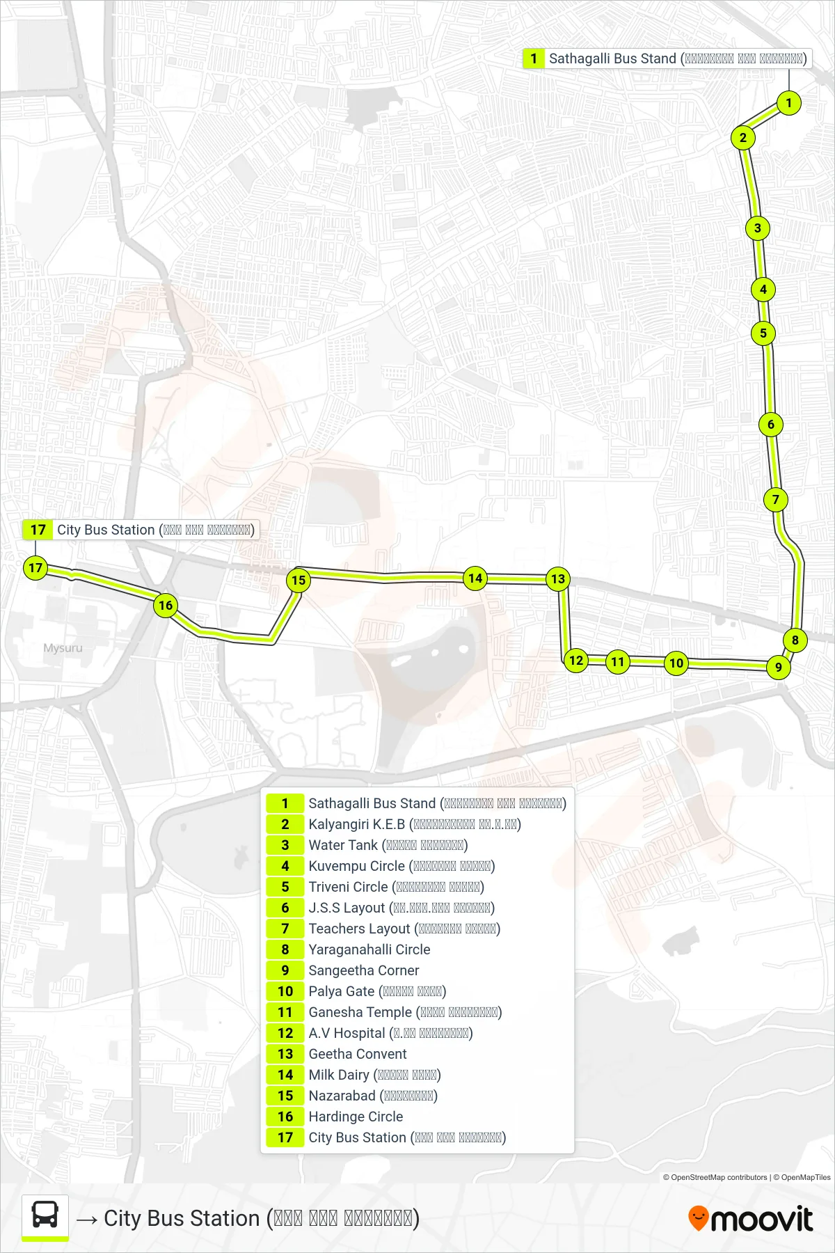
Stops list (80S - → City Bus Station (ನಗರ ಬಸ್ ನಿಲ್ದಾಣ))
- Sathagalli Bus Stand (ಸಾತಗಳ್ಳಿ ಬಸ್ ನಿಲ್ದಾಣ)
- Kalyangiri K.E.B (ಕಲ್ಯಾಣಗಿರಿ ಕೆ.ಇ.ಬಿ)
- Water Tank (ವಾಟರ್ ಟ್ಯಾಂಕ್)
- Kuvempu Circle (ಕುವೆಂಪು ವೃತ್ತ)
- Triveni Circle (ತ್ರಿವೇಣಿ ವೃತ್ತ)
- J.S.S Layout (ಜೆ.ಎಸ್.ಎಸ್ ಬಡಾವಣೆ)
- Teachers Layout (ಟೀಚರ್ಸ್ ಲೇಔಟ್)
- Yaraganahalli Circle
- Sangeetha Corner
- Palya Gate (ಪಾಳ್ಯ ಗೇಟ್)
- Ganesha Temple (ಗಣೇಶ ದೇವಸ್ಥಾನ)
- A.V Hospital (ಎ.ವಿ ಆಸ್ಪತ್ರೆ)
- Geetha Convent
- Milk Dairy (ಹಾಲಿನ ಡೈರಿ)
- Nazarabad (ನಜರಾಬಾದ್)
- Hardinge Circle
- City Bus Station (ನಗರ ಬಸ್ ನಿಲ್ದಾಣ)