
8-9 Bus Route Map
View the 8-9 route map and see all 8-9 stops along the route. The map of 8-9 shows where the bus travels and the location of each stop, making it easy to understand the entire route at a glance.
Explore ATM Messina routes on the map and see where ATM Messina bus services operate. Use the 8-9 map to find bus stops and see how the 8-9 connects different areas along its trip.
All 8-9 stops on the map are displayed in route order, helping you follow the 8-9 bus from the first stop to the last.
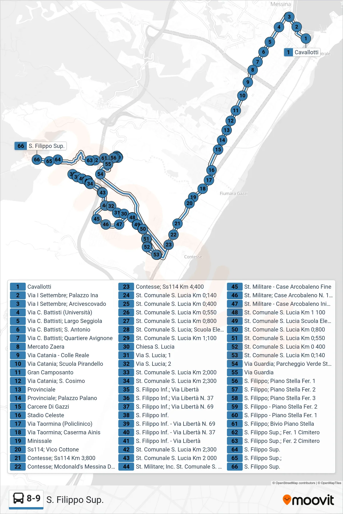
Stops list (8-9 - Upper St. Filippo)
- Cavallotti
- Via I Settembre, INA Building
- September I Street; Archbishop's Palace
- C. Battisti Street (University)
- Via C. Battisti, Seggiola Square
- Via C. Battisti; St. Antonio
- C. Battisti Street; Avignone District
- Zaera Market
- Catania Street - Royal Hill
- Catania Street, Pirandello School
- Great Cemetery
- Catania Street; St. Cosimo
- Provincial
- Provincial - Palano Palace
- Gazzi Prison
- Celeste Stadium
- Via Taormina (Hospital)
- Via Taormina; Ainis Barracks
- Minissale
- State Road 114; Vico Cottone
- Contesse - State Road 114 Km 3.800
- Contesse; McDonald's Messina Drive
- Contesse, State Road 114 Km 4.400
- Municipal Street S. Lucia Km 0.140
- Municipal Road Santa Lucia Km 0.400
- Municipal Road St Lucia Km 0.550
- Municipal St. S. Lucia Km 0.800
- St. Lucia Municipal Road - Elementary School
- Municipal Road St. Lucia Km 1.100
- Saint Lucia Church
- St. Lucia Street; 1
- St. Lucia Street; 2
- Municipal Road Santa Lucia Km 2.000
- Municipal Road S. Lucia Km 2;300
- Lower S. Filippo; Via Libertà
- S. Filippo Lower; Liberty Street No. 37
- S. Filippo Lower; Liberty Street No. 69
- Lower S. Filippo
- St. Filippo Lower - Liberty Street No. 69
- Lower S. Filippo - 37 Liberty Street
- Lower San Filippo - Liberty Street
- Municipal Road S. Lucia Km 2;300
- Municipal Road S. Lucia Km 2 000
- Military Street, Municipal Road S. Lucia Junction
- Military Road - Rainbow Houses End
- Military St.; Rainbow Houses No. 173
- Military St. - Rainbow Houses Start
- Municipal Road S. Lucia Km 1 100
- St. Lucia Municipal School
- Municipal St. S. Lucia Km 0.800
- Municipal Road St Lucia Km 0.550
- Municipal Road S. Lucia Km 0 400
- Municipal Street S. Lucia Km 0.140
- Via Guardia; Stadium Green Parking
- Guard Street
- S. Filippo; Piano Stella Stop 1
- S. Filippo; Piano Stella Stop 2
- S. Filippo; Piano Stella Stop 3
- S. Filippo - Piano Stella Stop 2
- S. Filippo - Piano Stella Stop 1
- S. Filippo; Piano Stella Junction
- S. Filippo Upper; Stop 1 Cemetery
- S. Filippo Upper, Cemetery Stop 2
- Upper St. Filippo
- Upper St. Filippo
- Upper St. Filippo