
901 Light Rail Route Map
View the 901 route map and see all 901 stops along the route. The map of 901 shows where the light rail travels and the location of each stop, making it easy to understand the entire route at a glance.
Explore DVG AG routes on the map and see where DVG AG light rail services operate. Use the 901 map to find light rail stations and see how the 901 connects different areas along its trip.
All 901 stops on the map are displayed in route order, helping you follow the 901 light rail from the first station to the last.
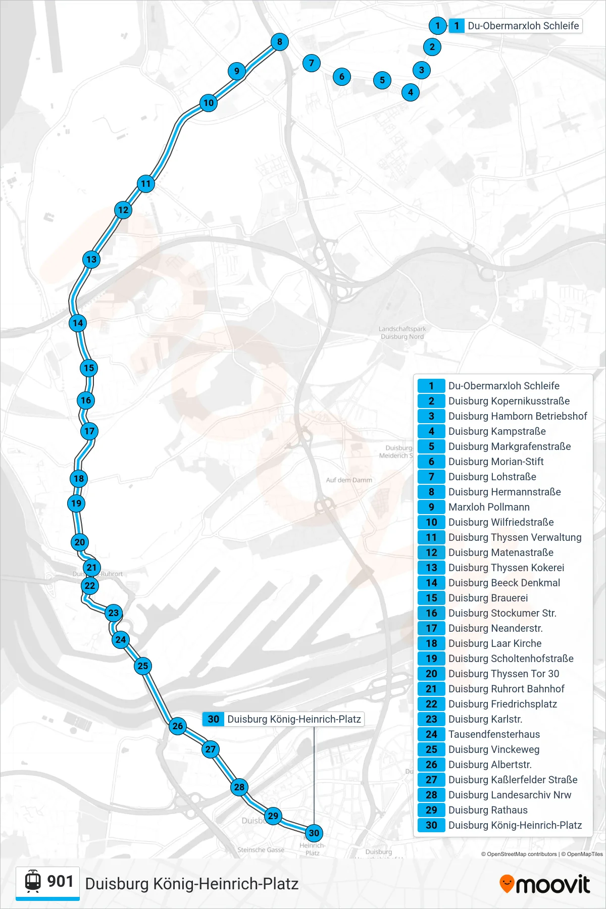
Stops list (901 - Duisburg König-Heinrich-Platz)
- Du-Obermarxloh Schleife
- Duisburg Kopernikusstraße
- Duisburg Hamborn Betriebshof
- Duisburg Kampstraße
- Duisburg Markgrafenstraße
- Duisburg Morian-Stift
- Duisburg Lohstraße
- Duisburg Hermannstraße
- Marxloh Pollmann
- Duisburg Wilfriedstraße
- Duisburg Thyssen Verwaltung
- Duisburg Matenastraße
- Duisburg Thyssen Kokerei
- Duisburg Beeck Denkmal
- Duisburg Brauerei
- Duisburg Stockumer Str.
- Duisburg Neanderstr.
- Duisburg Laar Kirche
- Duisburg Scholtenhofstraße
- Duisburg Thyssen Tor 30
- Duisburg Ruhrort Bahnhof
- Duisburg Friedrichsplatz
- Duisburg Karlstr.
- Tausendfensterhaus
- Duisburg Vinckeweg
- Duisburg Albertstr.
- Duisburg Kaßlerfelder Straße
- Duisburg Landesarchiv Nrw
- Duisburg Rathaus
- Duisburg König-Heinrich-Platz
Change direction
- Route Map - 901 - Marxloh Pollmann
- Route Map - 901 - Marxloh Pollmann
- Route Map - 901 - Du-Obermarxloh Schleife
- Route Map - 901 - Duisburg Hbf
- Route Map - 901 - Duisburg König-Heinrich-Platz
- Route Map - 901 - Duisburg Hermannstraße
- Route Map - 901 - Mülheim Hauptbahnhof
- Route Map - 901 - Duisburg Zoo/Uni
- Route Map - 901 - Duisburg Hermannstraße
- Route Map - 901 - Duisburg Scholtenhofstraße