
913 Bus Route Map
View the 913 route map and see all 913 stops along the route. The map of 913 shows where the bus travels and the location of each stop, making it easy to understand the entire route at a glance.
Explore Niederrheinische VKB routes on the map and see where Niederrheinische VKB bus services operate. Use the 913 map to find bus stops and see how the 913 connects different areas along its trip.
All 913 stops on the map are displayed in route order, helping you follow the 913 bus from the first stop to the last.
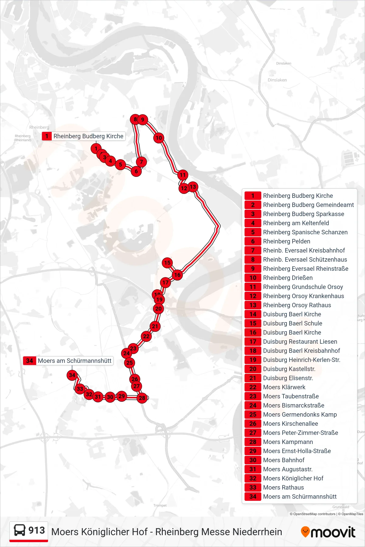
Stops list (913 - Moers am Schürmannshütt)
- Rheinberg Budberg Kirche
- Rheinberg Budberg Gemeindeamt
- Rheinberg Budberg Sparkasse
- Rheinberg am Keltenfeld
- Rheinberg Spanische Schanzen
- Rheinberg Pelden
- Rheinb. Eversael Kreisbahnhof
- Rheinb. Eversael Schützenhaus
- Rheinberg Eversael Rheinstraße
- Rheinberg Drießen
- Rheinberg Grundschule Orsoy
- Rheinberg Orsoy Krankenhaus
- Rheinberg Orsoy Rathaus
- Duisburg Baerl Kirche
- Duisburg Baerl Schule
- Duisburg Baerl Kirche
- Duisburg Restaurant Liesen
- Duisburg Baerl Kreisbahnhof
- Duisburg Heinrich-Kerlen-Str.
- Duisburg Kastellstr.
- Duisburg Elisenstr.
- Moers Klärwerk
- Moers Taubenstraße
- Moers Bismarckstraße
- Moers Germendonks Kamp
- Moers Kirschenallee
- Moers Peter-Zimmer-Straße
- Moers Kampmann
- Moers Ernst-Holla-Straße
- Moers Bahnhof
- Moers Augustastr.
- Moers Königlicher Hof
- Moers Rathaus
- Moers am Schürmannshütt
Change direction
- Route Map - 913 - Rheinberg Schulzentrum
- Route Map - 913 - Rheinberg Grundschule Orsoy
- Route Map - 913 - Moers Campus Moers
- Route Map - 913 - Rheinberg Orsoy Rathaus
- Route Map - 913 - Rheinberg Budberg Kirche
- Route Map - 913 - Rheinberg Clevische Straße
- Route Map - 913 - Rheinberg Clevische Straße
- Route Map - 913 - Rheinberg Grundschule Orsoy
- Route Map - 913 - Rheinberg Orsoyerberg
- Route Map - 913 - Moers Königlicher Hof
- Route Map - 913 - Rheinberg Orsoy Rathaus
- Route Map - 913 - Rheinberg Auf Dem Berg
- Route Map - 913 - Rheinb. Grundschule Lutherstr.
- Route Map - 913 - Duisburg Binsheim Bosch
- Route Map - 913 - Rheinberg Messe Niederrhein
- Route Map - 913 - Moers Hülsdonk Nord
- Route Map - 913 - Rheinberg Auf Dem Berg