
B+ Tram Route Map
View the B+ route map and see all B+ stops along the route. The map of B+ shows where the tram travels and the location of each stop, making it easy to understand the entire route at a glance.
Explore routes on the map and see where tram services operate. Use the B+ map to find tram stations and see how the B+ connects different areas along its trip.
All B+ stops on the map are displayed in route order, helping you follow the B+ tram from the first station to the last.
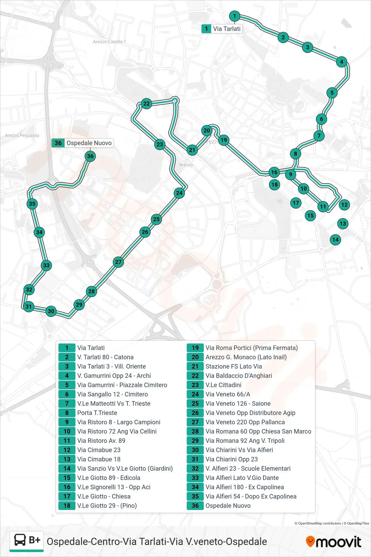
Stops list (B+ - New Hospital)
- Via Tarlati
- Via Tarlati 80 - Catona
- Via Tarlati 3 - Oriental Village
- Gamurrini Street Opposite 24 - Arches
- Gamurrini Street - Cemetery Square
- Via Sangallo 12 - Cemetery
- Matteotti Avenue towards Trieste
- Trieste Gate
- Via Ristoro 8 - Campioni Square
- 72 Ristoro Street Corner Cellini Street
- Via Ristoro No. 89
- Via Cimabue 23
- Cimabue Street 18
- Sanzio Street at Giotto Ave (Gardens)
- V.Le Giotto 89 - Newsstand
- Signorelli Avenue 13 - Opposite ACI
- Giotto Avenue - Church
- Giotto Avenue 29 - (Pino)
- Roma Street Porticos (First Stop)
- Arezzo G. Monaco (INAIL Side)
- Railway Station Via Side
- Baldaccio D'Anghiari Street
- Citizens Avenue
- Via Veneto 66/A
- Via Veneto 126 - Saione
- Via Veneto Opposite Agip Gas Station
- Via Veneto 220 Opposite Pallanca
- Via Romana 60 Opposite San Marco Church
- Via Romana 92 Corner Tripoli St
- Via Chiarini at Via Alfieri
- Opposite 23 Chiarini Street
- Alfieri Street 23 - Elementary School
- Alfieri Street by Gio Dante
- Via Alfieri 180 - Former Terminal
- Via Alfieri 54 - Dopo Ex Capolinea
- New Hospital