
BKR Bus Route Map
View the BKR route map and see all BKR stops along the route. The map of BKR shows where the bus travels and the location of each stop, making it easy to understand the entire route at a glance.
Explore Niederrheinische VKB routes on the map and see where Niederrheinische VKB bus services operate. Use the BKR map to find bus stops and see how the BKR connects different areas along its trip.
All BKR stops on the map are displayed in route order, helping you follow the BKR bus from the first stop to the last.
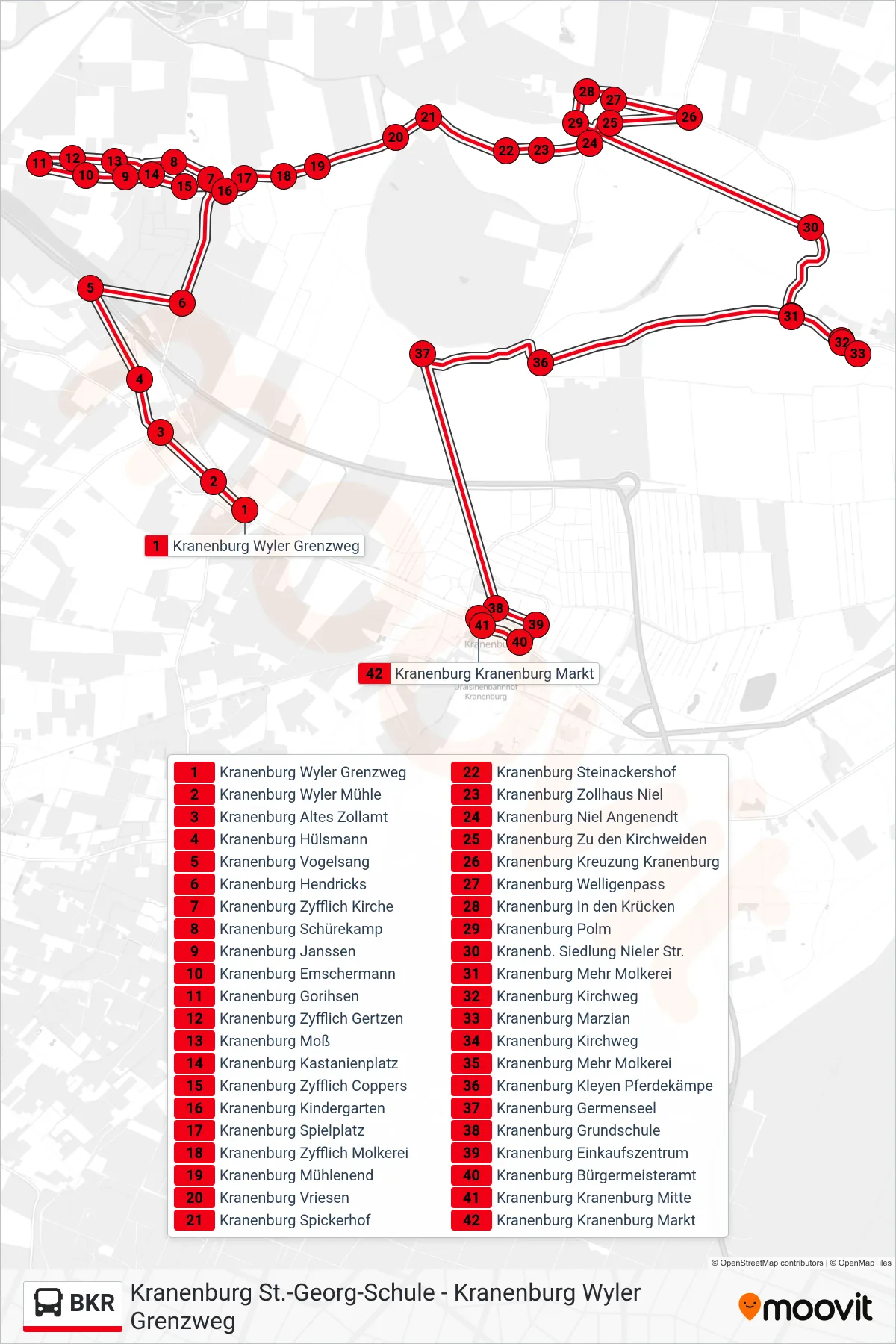
Stops list (BKR - Kranenburg Kranenburg Markt)
- Kranenburg Wyler Grenzweg
- Kranenburg Wyler Mühle
- Kranenburg Altes Zollamt
- Kranenburg Hülsmann
- Kranenburg Vogelsang
- Kranenburg Hendricks
- Kranenburg Zyfflich Kirche
- Kranenburg Schürekamp
- Kranenburg Janssen
- Kranenburg Emschermann
- Kranenburg Gorihsen
- Kranenburg Zyfflich Gertzen
- Kranenburg Moß
- Kranenburg Kastanienplatz
- Kranenburg Zyfflich Coppers
- Kranenburg Kindergarten
- Kranenburg Spielplatz
- Kranenburg Zyfflich Molkerei
- Kranenburg Mühlenend
- Kranenburg Vriesen
- Kranenburg Spickerhof
- Kranenburg Steinackershof
- Kranenburg Zollhaus Niel
- Kranenburg Niel Angenendt
- Kranenburg Zu den Kirchweiden
- Kranenburg Kreuzung Kranenburg
- Kranenburg Welligenpass
- Kranenburg In den Krücken
- Kranenburg Polm
- Kranenb. Siedlung Nieler Str.
- Kranenburg Mehr Molkerei
- Kranenburg Kirchweg
- Kranenburg Marzian
- Kranenburg Kirchweg
- Kranenburg Mehr Molkerei
- Kranenburg Kleyen Pferdekämpe
- Kranenburg Germenseel
- Kranenburg Grundschule
- Kranenburg Einkaufszentrum
- Kranenburg Bürgermeisteramt
- Kranenburg Kranenburg Mitte
- Kranenburg Kranenburg Markt
Change direction
- Route Map - BKR - Kranenburg Wyler Grenzweg
- Route Map - BKR - Kranenburg Nütterden Kirche
- Route Map - BKR - Kranenburg Euregio Realschule
- Route Map - BKR - Kranenburg Einkaufszentrum
- Route Map - BKR - Kranenburg St.-Georg-Schule
- Route Map - BKR - Kranenburg Wyler Mühle
- Route Map - BKR - Kranenburg Germenseel
- Route Map - BKR - Kranenburg Grundschule
- Route Map - BKR - Kranenburg Euregio Realschule
- Route Map - BKR - Kranenburg Grafwegen
- Route Map - BKR - Kranenburg Kreuzung Kranenburg
- Route Map - BKR - Kranenburg Marzian
- Route Map - BKR - Kranenburg Postweg
- Route Map - BKR - Kranenburg Zyfflich Coppers
- Route Map - BKR - Kranenburg Feuerwehr
- Route Map - BKR - Kranenburg Zyfflich Kirche