
Bus Bus Route Map
View the Bus route map and see all Bus stops along the route. The map of Bus shows where the bus travels and the location of each stop, making it easy to understand the entire route at a glance.
Explore Ferrotramviaria General Transport Division routes on the map and see where Ferrotramviaria General Transport Division bus services operate. Use the Bus map to find bus stops and see how the Bus connects different areas along its trip.
All Bus stops on the map are displayed in route order, helping you follow the Bus bus from the first stop to the last.
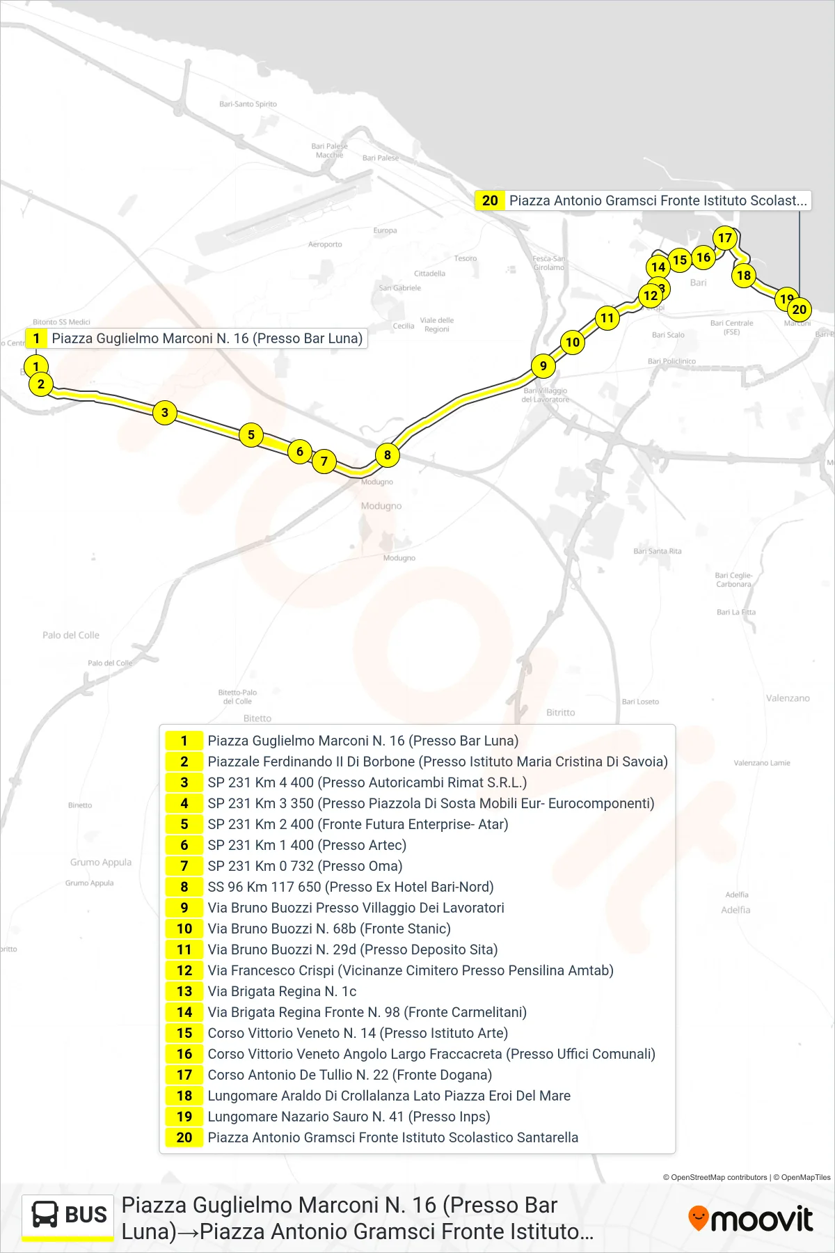
Stops list (Bus - Guglielmo Marconi Square No. 16 (Near Bar Luna)→Antonio Gramsci Square Opposite Santarella School)
- Guglielmo Marconi Square No. 16 (Near Bar Luna)
- Ferdinand II of Bourbon Square (Near Maria Cristina Di Savoia Institute)
- SP 231 Km 4 400 (Near Rimat Auto Parts S.R.L.)
- SP 231 Km 3 350 (Near Mobili Eur-Eurocomponenti Rest Area)
- SP 231 Km 2 400 (Opposite Futura Enterprise- Atar)
- SP 231 Km 1 400 (Near Artec)
- Provincial Road 231 Km 0.732 (Near Oma)
- SS 96 Km 117 650 (Near Former Hotel Bari-North)
- Bruno Buozzi Street Near Workers Village
- Bruno Buozzi Street No. 68b (Opposite Stanic)
- Bruno Buozzi Street No. 29d (Near Sita Depot)
- Francesco Crispi Street (Near Cemetery At Amtab Shelter)
- Queen Brigade Street 1c
- Via Brigata Regina Opposite No. 98 (Opposite Carmelites)
- Corso Vittorio Veneto No. 14 (At Art Institute)
- Corso Vittorio Veneto Corner Largo Fraccacreta (Near Municipal Offices)
- Antonio De Tullio Avenue No. 22 (Customs Front)
- Araldo Di Crollalanza Waterfront Sea Heroes Square Side
- Nazario Sauro Waterfront No. 41 (Near INPS)
- Antonio Gramsci Square Opposite Santarella School
Change direction
- Route Map - BUS - Hippocrates Avenue Near Public Parking Monsignor Dimiccoli Hospital→Antonio Gramsci Square Opposite Santarella School
- Route Map - BUS - Giuseppe Di Vagno Square Near Giovanni Bovio School→Antonio Gramsci Square Opposite Santarella School
- Route Map - BUS - 117 Venezia Giulia Avenue (Opposite FNB Station)→Raffaele Paolucci Street (Near FNB Station)
- Route Map - BUS - Hippocrates Avenue Near Public Parking Monsignor Dimiccoli Hospital→Giuseppe Garibaldi Avenue No. 27
- Route Map - BUS - Giuseppe Di Vagno Square Near Giovanni Bovio School→Guglielmo Marconi Square No. 16 (Near Bar Luna)
- Route Map - BUS - 117 Venezia Giulia Avenue (Opposite FNB Station)→Guglielmo Marconi Square No. 16 (Near Bar Luna)
- Route Map - BUS - Raffaele Paolucci Street (Near FNB Station)→Via Caldarola Near Multipurpose School Institute
- Route Map - BUS - Raffaele Paolucci Street (Near FNB Station)→Antonio Gramsci Square Opposite Santarella School
- Route Map - BUS - Guglielmo Marconi Street No. 51 (Near FNB Station)→Antonio Gramsci Square Opposite Santarella School
- Route Map - BUS - 117 Venezia Giulia Avenue (Opposite FNB Station)→Antonio Gramsci Square Opposite Santarella School
- Route Map - BUS - Ferdinand of Aragon Square Near FNB Station→Antonio Gramsci Square Opposite Santarella School