
CANBY LOOP Bus Route Map
View the CANBY LOOP route map and see all CANBY LOOP stops along the route. The map of CANBY LOOP shows where the bus travels and the location of each stop, making it easy to understand the entire route at a glance.
Explore Canby Area Transit routes on the map and see where Canby Area Transit bus services operate. Use the CANBY LOOP map to find bus stops and see how the CANBY LOOP connects different areas along its trip.
All CANBY LOOP stops on the map are displayed in route order, helping you follow the CANBY LOOP bus from the first stop to the last.
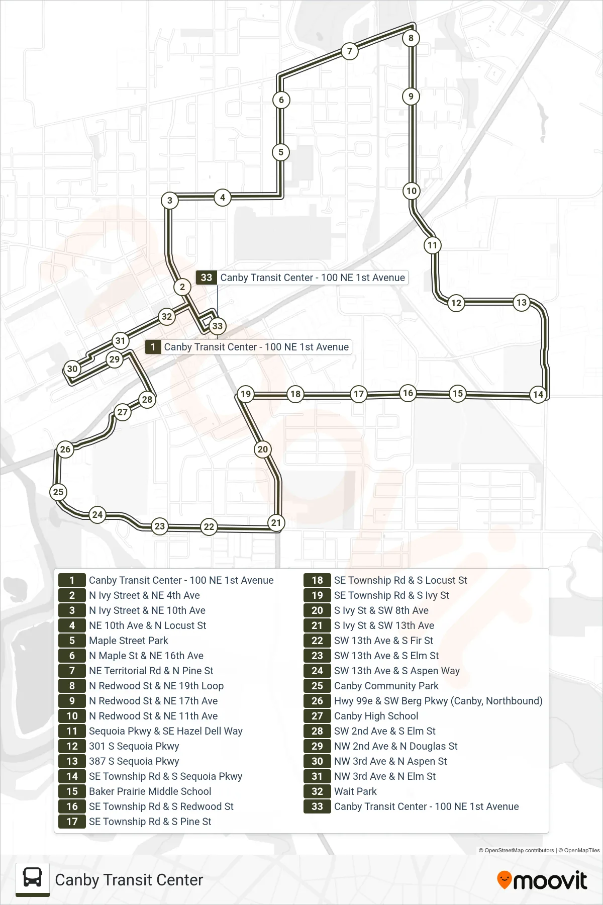
Stops list (CANBY LOOP - Canby Transit Center)
- Canby Transit Center - 100 NE 1st Avenue
- N Ivy Street & NE 4th Ave
- N Ivy Street & NE 10th Ave
- NE 10th Ave & N Locust St
- Maple Street Park
- N Maple St & NE 16th Ave
- NE Territorial Rd & N Pine St
- N Redwood St & NE 19th Loop
- N Redwood St & NE 17th Ave
- N Redwood St & NE 11th Ave
- Sequoia Pkwy & SE Hazel Dell Way
- 301 S Sequoia Pkwy
- 387 S Sequoia Pkwy
- SE Township Rd & S Sequoia Pkwy
- Baker Prairie Middle School
- SE Township Rd & S Redwood St
- SE Township Rd & S Pine St
- SE Township Rd & S Locust St
- SE Township Rd & S Ivy St
- S Ivy St & SW 8th Ave
- S Ivy St & SW 13th Ave
- SW 13th Ave & S Fir St
- SW 13th Ave & S Elm St
- SW 13th Ave & S Aspen Way
- Canby Community Park
- Hwy 99e & SW Berg Pkwy (Canby, Northbound)
- Canby High School
- SW 2nd Ave & S Elm St
- NW 2nd Ave & N Douglas St
- NW 3rd Ave & N Aspen St
- NW 3rd Ave & N Elm St
- Wait Park
- Canby Transit Center - 100 NE 1st Avenue