
E Bus Route Map
View the E route map and see all E stops along the route. The map of E shows where the bus travels and the location of each stop, making it easy to understand the entire route at a glance.
Explore SWB Stadtwerke Bonn Verkehrs GmbH routes on the map and see where SWB Stadtwerke Bonn Verkehrs GmbH bus services operate. Use the E map to find bus stops and see how the E connects different areas along its trip.
All E stops on the map are displayed in route order, helping you follow the E bus from the first stop to the last.
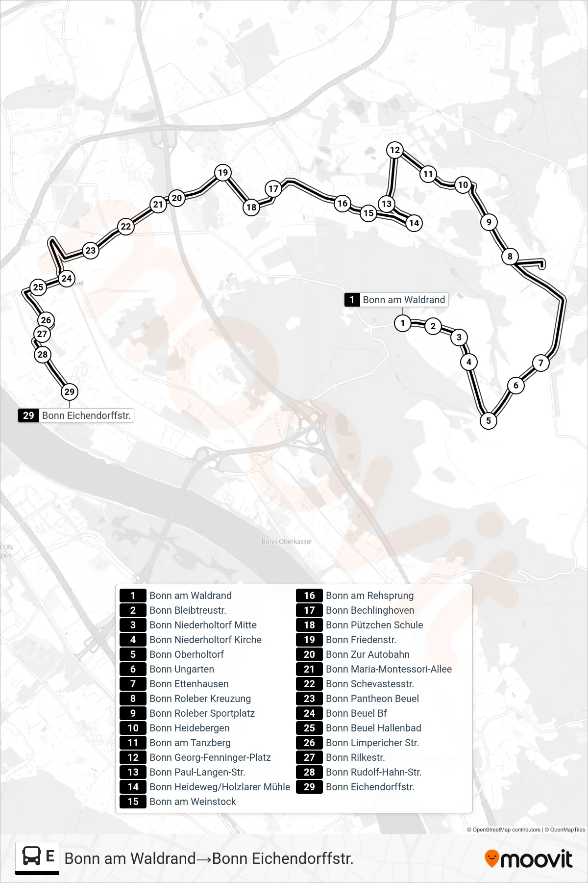
Stops list (E - Bonn am Waldrand→Bonn Eichendorffstr.)
- Bonn am Waldrand
- Bonn Bleibtreustr.
- Bonn Niederholtorf Mitte
- Bonn Niederholtorf Kirche
- Bonn Oberholtorf
- Bonn Ungarten
- Bonn Ettenhausen
- Bonn Roleber Kreuzung
- Bonn Roleber Sportplatz
- Bonn Heidebergen
- Bonn am Tanzberg
- Bonn Georg-Fenninger-Platz
- Bonn Paul-Langen-Str.
- Bonn Heideweg/Holzlarer Mühle
- Bonn am Weinstock
- Bonn am Rehsprung
- Bonn Bechlinghoven
- Bonn Pützchen Schule
- Bonn Friedenstr.
- Bonn Zur Autobahn
- Bonn Maria-Montessori-Allee
- Bonn Schevastesstr.
- Bonn Pantheon Beuel
- Bonn Beuel Bf
- Bonn Beuel Hallenbad
- Bonn Limpericher Str.
- Bonn Rilkestr.
- Bonn Rudolf-Hahn-Str.
- Bonn Eichendorffstr.
Change direction
- Route Map - E - Bonn Georg-Fenninger-Platz→Bonn Tannenbusch Mitte
- Route Map - E - Bonn Adelheidisschule→Bonn Gartenstr.
- Route Map - E - Bonn Hedwigschule→Bonn Tannenbusch Mitte
- Route Map - E - Bonn Kleinfeldstr.→Bonn Beuel Bf
- Route Map - E - Bonn Baunscheidtstr.→Bonn Buchholzstr.
- Route Map - E - Bonn Gielgen→Bonn Friedenstr.
- Route Map - E - Bonn Bad Godesberg Bf / Rheinallee→Bonn Nicolaus-Cusanus-Gymnasium
- Route Map - E - Bonn Agnetendorfer Str.→Bonn Bernhardkirche
- Route Map - E - Bonn Riesengebirgsstr.→Bonn Duisdorf Bf
- Route Map - E - Bonn Kardinal-Frings-Gymnasium→Bonn Bertha-Von-Suttner-Pl./Beethovenhaus
- Route Map - E - Bonn Rochusstr./Bundesministerien→Bonn Bernhardkirche
- Route Map - E - Bonn Rathaus Hardtberg→Bonn Hedwigschule
- Route Map - E - Bonn Josephinum→Bonn Hbf
- Route Map - E - Bonn Pappelweg→Bonn Eduard-Otto-Str.
- Route Map - E - Bonn Im Rosenberg→Bonn Aloisiuskolleg
- Route Map - E - Bonn Pappelweg→Bonn Hochkreuz/Deutsches Museum Bonn
- Route Map - E - Bonn Ückesdorf Gymnasium→Bonn Schneidemühler Str.
- Route Map - E - Bonn Mondorfer Fähre→Bonn Auf Dem Hügel
- Route Map - E - Bonn Josephinum→Bornheim Hersel
- Route Map - E - Bonn Kardinal-Frings-Gymnasium→Bonn Kleinfeldstr.
- Route Map - E - Bonn Ückesdorf Gymnasium→Bonn Duisdorf Bf
- Route Map - E - Bonn Beuel Bf→Bonn Georg-Fenninger-Platz
- Route Map - E - Bonn Konrad-Adenauer-Gymnasium→Bonn Gielgen
- Route Map - E - Bonn Waldschule→Bonn Poppelsdorfer Platz
- Route Map - E - Bonn Röttgen Schleife→Bonn Josephinum
- Route Map - E - Bonn Duisdorf Bf→Bonn Ückesdorf Gymnasium
- Route Map - E - Bonn Herseler Str.→Bonn Magdalenenplatz
- Route Map - E - Bonn Im Rosenberg→Bonn Loki-Schmidt-Platz
- Route Map - E - Bonn Nicolaus-Cusanus-Gymnasium→Bonn Bad Godesberg Bf / Rheinallee
- Route Map - E - Bonn Konrad-Adenauer-Gymnasium→Bonn Bad Godesberg Bf / Ria-Maternus-Platz
- Route Map - E - Bonn Gartenstr.→Bonn Adelheidisschule
- Route Map - E - Bonn Provinzialstr.→Bonn Robert-Schuman-Platz
- Route Map - E - Bonn Uniklinikum Süd→Bonn Rochusstr./Bundesministerien
- Route Map - E - Bonn Adelheidisschule→Bonn Bertha-Von-Suttner-Pl./Beethovenhaus
- Route Map - E - Bonn Kleinfeldstr.→Bonn Eichendorffstr.
- Route Map - E - Bonn Marienforster Steinweg→Bonn Hochkreuz/Deutsches Museum Bonn
- Route Map - E - Bonn Hbf→Bonn Ramersdorf
- Route Map - E - Bonn Gartenstr.→Bonn Heideweg/Holzlarer Mühle
- Route Map - E - Bonn Loki-Schmidt-Platz→Bonn Bad Godesberg Bf / Rheinallee
- Route Map - E - Bonn Otto-Kühne-Schule→Bonn Bad Godesberg Bf / Rheinallee
- Route Map - E - Bonn Schneidemühler Str.→Bonn Ückesdorf Gymnasium
- Route Map - E - Bonn Loki-Schmidt-Platz→Bonn Ellesdorfer Str.
- Route Map - E - Bonn Lessenich Sportplatz→Bonn Uniklinikum Süd
- Route Map - E - Bonn Mondorfer Fähre→Bonn Uniklinikum Süd
- Route Map - E - Bonn Gielgen→Bonn Konrad-Adenauer-Gymnasium