
E Bus Route Map
View the E route map and see all E stops along the route. The map of E shows where the bus travels and the location of each stop, making it easy to understand the entire route at a glance.
Explore Rheinbahn routes on the map and see where Rheinbahn bus services operate. Use the E map to find bus stops and see how the E connects different areas along its trip.
All E stops on the map are displayed in route order, helping you follow the E bus from the first stop to the last.
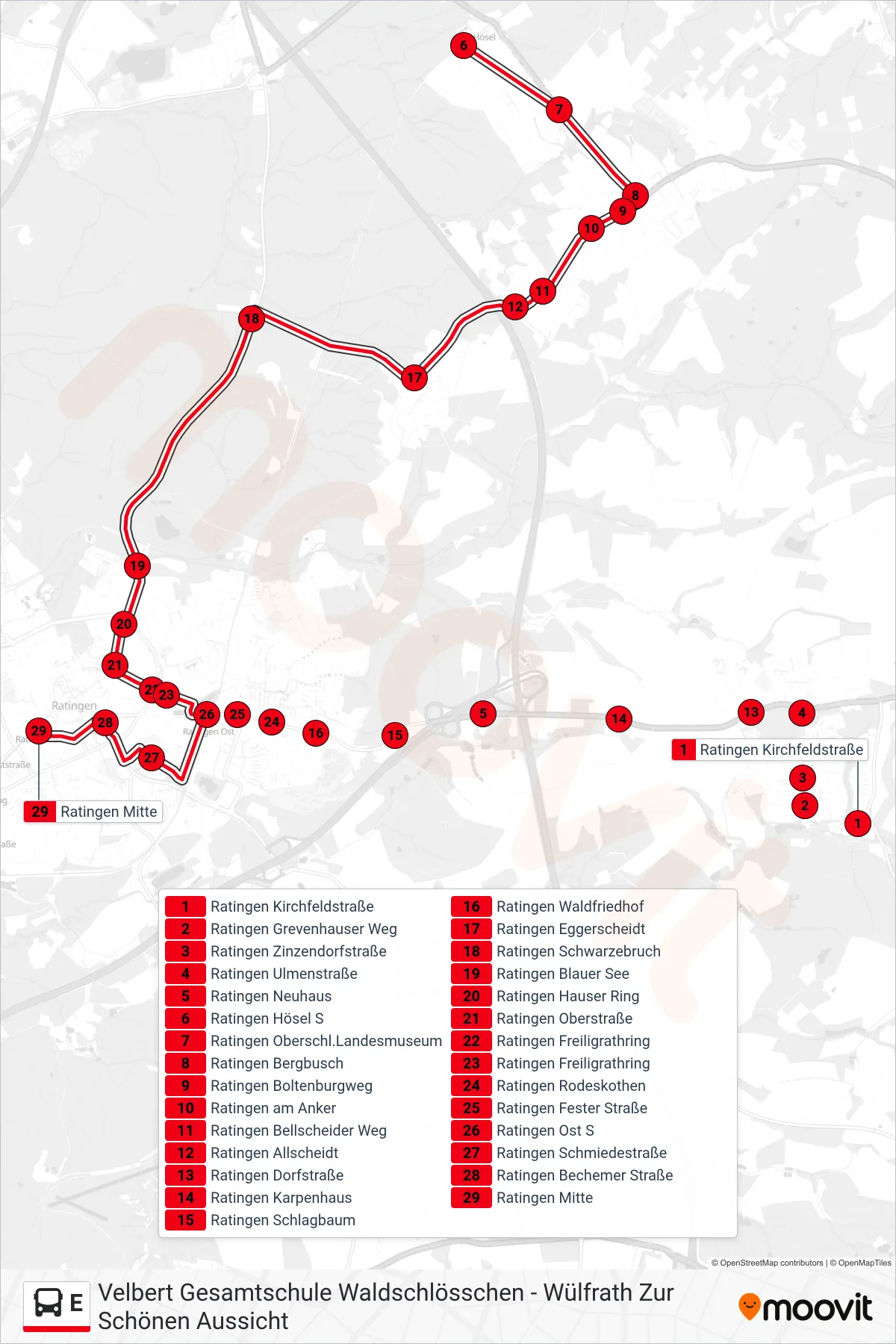
Stops list (E - Ratingen Mitte)
- Ratingen Kirchfeldstraße
- Ratingen Grevenhauser Weg
- Ratingen Zinzendorfstraße
- Ratingen Ulmenstraße
- Ratingen Neuhaus
- Ratingen Hösel S
- Ratingen Oberschl.Landesmuseum
- Ratingen Bergbusch
- Ratingen Boltenburgweg
- Ratingen am Anker
- Ratingen Bellscheider Weg
- Ratingen Allscheidt
- Ratingen Dorfstraße
- Ratingen Karpenhaus
- Ratingen Schlagbaum
- Ratingen Waldfriedhof
- Ratingen Eggerscheidt
- Ratingen Schwarzebruch
- Ratingen Blauer See
- Ratingen Hauser Ring
- Ratingen Oberstraße
- Ratingen Freiligrathring
- Ratingen Freiligrathring
- Ratingen Rodeskothen
- Ratingen Fester Straße
- Ratingen Ost S
- Ratingen Schmiedestraße
- Ratingen Bechemer Straße
- Ratingen Mitte
Change direction
- Route Map - E - Mettmann Ratinger Straße
- Route Map - E - Erkrath Haus Brück
- Route Map - E - Heiligenhaus Realschule
- Route Map - E - D-Kaiserpfalz
- Route Map - E - Mettmann Florastraße
- Route Map - E - Erkrath Erkrath S
- Route Map - E - Velbert Zob
- Route Map - E - Ratingen Dorfstraße
- Route Map - E - Hilden Süd S
- Route Map - E - Mettmann Seibelstraße
- Route Map - E - D-Morper Straße
- Route Map - E - Me-Stadtwald S
- Route Map - E - Erkrath Kemperdick
- Route Map - E - Mettmann Käthe-Kollwitz-Ring
- Route Map - E - Haan, Markt
- Route Map - E - Me-Jubiläumsplatz
- Route Map - E - Haan Dieker Straße
- Route Map - E - Mettmann T.-Turek-A./Naturfrei
- Route Map - E - Heiligenhaus Höseler Platz
- Route Map - E - Me-Stadtwald S
- Route Map - E - Mettmann Seibelstraße
- Route Map - E - Ratingen Hösel S
- Route Map - E - Haan-Gruiten
- Route Map - E - Velbert Gesamtschule Waldschlösschen
- Route Map - E - Heiligenhaus Ehemannshof
- Route Map - E - Me-Zentrum S
- Route Map - E - D-Am Zault
- Route Map - E - H'Haus In Der Blume/Stadtmitte
- Route Map - E - Haan Gruiten,Dorf
- Route Map - E - Erkrath Hochdahler Markt
- Route Map - E - Ratingen Dorfstraße
- Route Map - E - Wülfrath Zur Schönen Aussicht
- Route Map - E - Ratingen Ulmenstraße
- Route Map - E - Me-Jubiläumsplatz
- Route Map - E - Ratingen Mitte
- Route Map - E - Mettmann Benninghof
- Route Map - E - Heiligenhaus Unterilp
- Route Map - E - Heiligenhaus Realschule
- Route Map - E - Ratingen Kirchfeldstraße
- Route Map - E - H'Haus Tersteegen-Schule
- Route Map - E - Heiligenhaus Unterstadt
- Route Map - E - Heiligenhaus Haus Karrenberg
- Route Map - E - Ratingen Im Bruch
- Route Map - E - Heiligenhaus Abtskücher Straße