
E Light Rail Route Map
View the E route map and see all E stops along the route. The map of E shows where the light rail travels and the location of each stop, making it easy to understand the entire route at a glance.
Explore Karlsruher Verkehrsverbund routes on the map and see where Karlsruher Verkehrsverbund light rail services operate. Use the E map to find light rail stations and see how the E connects different areas along its trip.
All E stops on the map are displayed in route order, helping you follow the E light rail from the first station to the last.
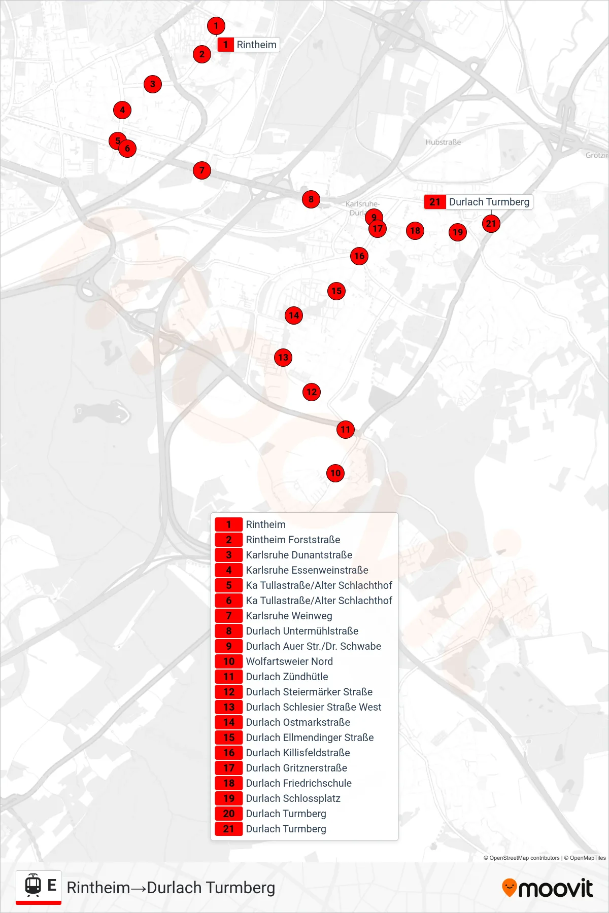
Stops list (E - Durlach Turmberg)
- Rintheim
- Rintheim Forststraße
- Karlsruhe Dunantstraße
- Karlsruhe Essenweinstraße
- Ka Tullastraße/Alter Schlachthof
- Ka Tullastraße/Alter Schlachthof
- Karlsruhe Weinweg
- Durlach Untermühlstraße
- Durlach Auer Str./Dr. Schwabe
- Wolfartsweier Nord
- Durlach Zündhütle
- Durlach Steiermärker Straße
- Durlach Schlesier Straße West
- Durlach Ostmarkstraße
- Durlach Ellmendinger Straße
- Durlach Killisfeldstraße
- Durlach Gritznerstraße
- Durlach Friedrichschule
- Durlach Schlossplatz
- Durlach Turmberg
- Durlach Turmberg
Change direction
- Route Map - E - Karlsruhe Rheinhafen
- Route Map - E - Ka Tullastraße/Alter Schlachthof
- Route Map - E - Rintheim
- Route Map - E - Karlsruhe Albtalbahnhof
- Route Map - E - Waldstadt Europäische Schule
- Route Map - E - Spöck Richard-Hecht-Schule
- Route Map - E - Oberreut Badeniaplatz
- Route Map - E - Ka Karlstor/Bundesgerichtshof
- Route Map - E - Wolfartsweier Nord
- Route Map - E - Durlach Bahnhof
- Route Map - E - Ka Hirtenweg/Technologiepark
- Route Map - E - Ka Marktplatz (Pyramide U)
- Route Map - E - Karlsruhe Rheinhafen
- Route Map - E - Blankenloch Nord
- Route Map - E - Karlsruhe Schillerstraße
- Route Map - E - Neureut-Heide
- Route Map - E - Daxlanden Dornröschenweg
- Route Map - E - Karlsruhe Yorckstraße
- Route Map - E - Mörsch Bach-West
- Route Map - E - Ka Europahalle/Europabad
- Route Map - E - Durlach Turmberg
- Route Map - E - Ka Tullastraße/Alter Schlachthof
- Route Map - E - Hagsfeld Reitschulschlag
- Route Map - E - Karlsruhe Einfahrt Über Gl. 21
- Route Map - E - Karlsruhe Einfahrt Über Gl. 21
- Route Map - E - Daxlanden Waidweg
- Route Map - E - Neureut Kirchfeld
- Route Map - E - Knielingen Nord