
E Rail Route Map
View the E route map and see all E stops along the route. The map of E shows where the rail travels and the location of each stop, making it easy to understand the entire route at a glance.
Explore Karlsruher Verkehrsverbund routes on the map and see where Karlsruher Verkehrsverbund rail services operate. Use the E map to find rail stations and see how the E connects different areas along its trip.
All E stops on the map are displayed in route order, helping you follow the E rail from the first station to the last.
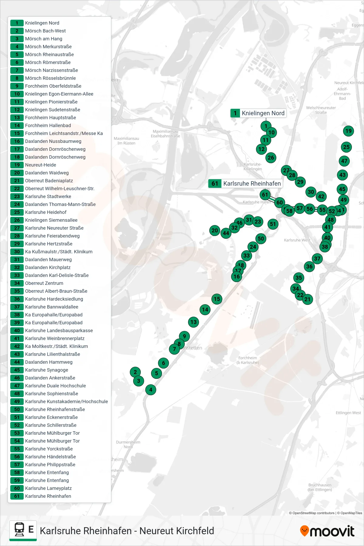
Stops list (E - Karlsruhe Rheinhafen)
- Knielingen Nord
- Mörsch Bach-West
- Mörsch am Hang
- Mörsch Merkurstraße
- Mörsch Rheinaustraße
- Mörsch Römerstraße
- Mörsch Narzissenstraße
- Mörsch Rösselsbrünnle
- Forchheim Oberfeldstraße
- Knielingen Egon-Eiermann-Allee
- Knielingen Pionierstraße
- Knielingen Sudetenstraße
- Forchheim Hauptstraße
- Forchheim Hallenbad
- Forchheim Leichtsandstr./Messe Ka
- Daxlanden Nussbaumweg
- Daxlanden Dornröschenweg
- Daxlanden Dornröschenweg
- Neureut-Heide
- Daxlanden Waidweg
- Oberreut Badeniaplatz
- Oberreut Wilhelm-Leuschner-Str.
- Karlsruhe Stadtwerke
- Daxlanden Thomas-Mann-Straße
- Karlsruhe Heidehof
- Knielingen Siemensallee
- Karlsruhe Neureuter Straße
- Karlsruhe Feierabendweg
- Karlsruhe Hertzstraße
- Ka Kußmaulstr./Städt. Klinikum
- Daxlanden Mauerweg
- Daxlanden Kirchplatz
- Daxlanden Karl-Delisle-Straße
- Oberreut Zentrum
- Oberreut Albert-Braun-Straße
- Karlsruhe Hardecksiedlung
- Karlsruhe Bannwaldallee
- Ka Europahalle/Europabad
- Ka Europahalle/Europabad
- Karlsruhe Landesbausparkasse
- Karlsruhe Weinbrennerplatz
- Ka Moltkestr./Städt. Klinikum
- Karlsruhe Lilienthalstraße
- Daxlanden Hammweg
- Karlsruhe Synagoge
- Daxlanden Ankerstraße
- Karlsruhe Duale Hochschule
- Karlsruhe Sophienstraße
- Karlsruhe Kunstakademie/Hochschule
- Karlsruhe Rheinhafenstraße
- Karlsruhe Eckenerstraße
- Karlsruhe Schillerstraße
- Karlsruhe Mühlburger Tor
- Karlsruhe Mühlburger Tor
- Karlsruhe Yorckstraße
- Karlsruhe Händelstraße
- Karlsruhe Philippstraße
- Karlsruhe Entenfang
- Karlsruhe Entenfang
- Karlsruhe Lameyplatz
- Karlsruhe Rheinhafen
Change direction
- Route Map - E - Blankenloch Nord
- Route Map - E - Mörsch Bach-West
- Route Map - E - Durlach Bahnhof
- Route Map - E - Ka Hirtenweg/Technologiepark
- Route Map - E - Karlsruhe Albtalbahnhof
- Route Map - E - Neureut Kirchfeld
- Route Map - E - Karlsruhe Tullastraße (E21)
- Route Map - E - Daxlanden Waidweg
- Route Map - E - Ka Marktplatz (Pyramide U)
- Route Map - E - Neureut-Heide
- Route Map - E - Karlsruhe Tivoli
- Route Map - E - Knielingen Nord
- Route Map - E - Karlsruhe Tullastraße (E21)
- Route Map - E - Ka Hirtenweg/Technologiepark
- Route Map - E - Rintheim
- Route Map - E - Spöck Richard-Hecht-Schule
- Route Map - E - Oberreut Badeniaplatz
- Route Map - E - Karlsruhe Rheinhafen
- Route Map - E - Hagsfeld Reitschulschlag
- Route Map - E - Ka Tullastraße/Alter Schlachthof
- Route Map - E - Daxlanden Dornröschenweg
- Route Map - E - Karlsruhe Tivoli
- Route Map - E - Ka Europahalle/Europabad