
E AM Bus Route Map
View the E AM route map and see all E AM stops along the route. The map of E AM shows where the bus travels and the location of each stop, making it easy to understand the entire route at a glance.
Explore TRACER Bus Service routes on the map and see where TRACER Bus Service bus services operate. Use the E AM map to find bus stops and see how the E AM connects different areas along its trip.
All E AM stops on the map are displayed in route order, helping you follow the E AM bus from the first stop to the last.
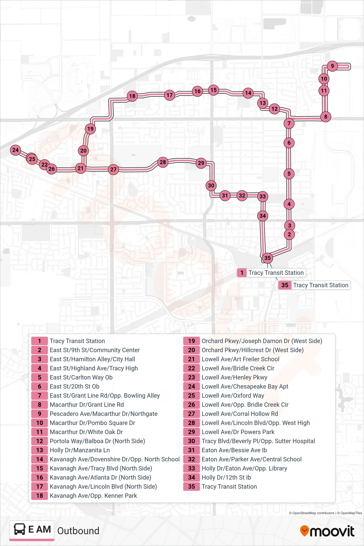
Stops list (E AM - Outbound)
- Tracy Transit Station
- East St/9th St/Community Center
- East St/Hamilton Alley/City Hall
- East St/Highland Ave/Tracy High
- East St/Carlton Way Ob
- East St/20th St Ob
- East St/Grant Line Rd/Opp. Bowling Alley
- Macarthur Dr/Grant Line Rd
- Pescadero Ave/Macarthur Dr/Northgate
- Macarthur Dr/Pombo Square Dr
- Macarthur Dr/White Oak Dr
- Portola Way/Balboa Dr (North Side)
- Holly Dr/Manzanita Ln
- Kavanagh Ave/Dovenshire Dr/Opp. North School
- Kavanagh Ave/Tracy Blvd (North Side)
- Kavanagh Ave/Atlanta Dr (North Side)
- Kavanagh Ave/Lincoln Blvd (North Side)
- Kavanagh Ave/Opp. Kenner Park
- Orchard Pkwy/Joseph Damon Dr (West Side)
- Orchard Pkwy/Hillcrest Dr (West Side)
- Lowell Ave/Art Freiler School
- Lowell Ave/Bridle Creek Cir
- Lowell Ave/Henley Pkwy
- Lowell Ave/Chesapeake Bay Apt
- Lowell Ave/Oxford Way
- Lowell Ave/Opp. Bridle Creek Cir
- Lowell Ave/Corral Hollow Rd
- Lowell Ave/Lincoln Blvd/Opp. West High
- Lowell Ave/Dr Powers Park
- Tracy Blvd/Beverly Pl/Opp. Sutter Hospital
- Eaton Ave/Bessie Ave Ib
- Eaton Ave/Parker Ave/Central School
- Holly Dr/Eaton Ave/Opp. Library
- Holly Dr/12th St Ib
- Tracy Transit Station