
F18 Bus Route Map
View the F18 route map and see all F18 stops along the route. The map of F18 shows where the bus travels and the location of each stop, making it easy to understand the entire route at a glance.
Explore Autobuses routes on the map and see where Autobuses bus services operate. Use the F18 map to find bus stops and see how the F18 connects different areas along its trip.
All F18 stops on the map are displayed in route order, helping you follow the F18 bus from the first stop to the last.
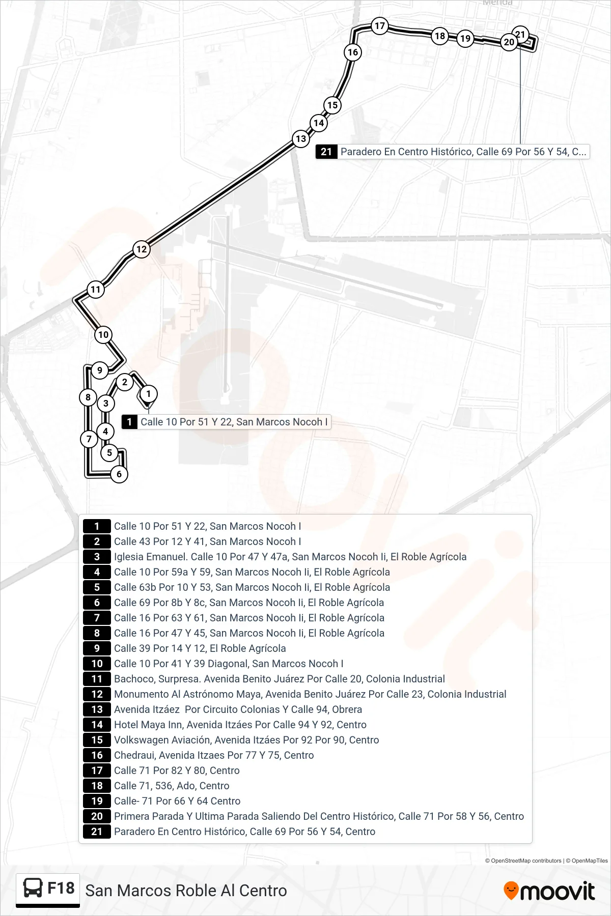
Stops list (F18 - San Marcos Roble Al Centro)
- Calle 10 Por 51 Y 22, San Marcos Nocoh I
- Calle 43 Por 12 Y 41, San Marcos Nocoh I
- Iglesia Emanuel. Calle 10 Por 47 Y 47a, San Marcos Nocoh Ii, El Roble Agrícola
- Calle 10 Por 59a Y 59, San Marcos Nocoh Ii, El Roble Agrícola
- Calle 63b Por 10 Y 53, San Marcos Nocoh Ii, El Roble Agrícola
- Calle 69 Por 8b Y 8c, San Marcos Nocoh Ii, El Roble Agrícola
- Calle 16 Por 63 Y 61, San Marcos Nocoh Ii, El Roble Agrícola
- Calle 16 Por 47 Y 45, San Marcos Nocoh Ii, El Roble Agrícola
- Calle 39 Por 14 Y 12, El Roble Agrícola
- Calle 10 Por 41 Y 39 Diagonal, San Marcos Nocoh I
- Bachoco, Surpresa. Avenida Benito Juárez Por Calle 20, Colonia Industrial
- Monumento Al Astrónomo Maya, Avenida Benito Juárez Por Calle 23, Colonia Industrial
- Avenida Itzáez Por Circuito Colonias Y Calle 94, Obrera
- Hotel Maya Inn, Avenida Itzáes Por Calle 94 Y 92, Centro
- Volkswagen Aviación, Avenida Itzáes Por 92 Por 90, Centro
- Chedraui, Avenida Itzaes Por 77 Y 75, Centro
- Calle 71 Por 82 Y 80, Centro
- Calle 71, 536, Ado, Centro
- Calle- 71 Por 66 Y 64 Centro
- Primera Parada Y Ultima Parada Saliendo Del Centro Histórico, Calle 71 Por 58 Y 56, Centro
- Paradero En Centro Histórico, Calle 69 Por 56 Y 54, Centro